
The Hindu Kush is an 800-kilometre-long (500 mi) mountain range in Central and South Asia to the west of the Himalayas. It stretches from central and western Afghanistan into northwestern Pakistan and far southeastern Tajikistan. The range forms the western section of the Hindu Kush Himalayan Region (HKH); to the north, near its northeastern end, the Hindu Kush buttresses the Pamir Mountains near the point where the borders of China, Pakistan and Afghanistan meet, after which it runs southwest through Pakistan and into Afghanistan near their border. The eastern end of the Hindu Kush in the north merges with the Karakoram Range. Towards its southern end, it connects with the Spin Ghar Range near the Kabul River. It divides the valley of the Amu Darya to the north from the Indus River valley to the south. The range has numerous high snow-capped peaks, with the highest point being Tirich Mir or Terichmir at 7,708 metres (25,289 ft) in the Chitral District of Khyber Pakhtunkhwa, Pakistan.

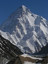
The Karakoram is a mountain range in Kashmir spanning the borders of Pakistan, China, and India, with the northwest extremity of the range extending to Afghanistan and Tajikistan. Most of the Karakoram mountain range falls under the jurisdiction of Gilgit-Baltistan which is controlled by Pakistan. Its highest peak, K2, is located in Gilgit-Baltistan. It begins in the Wakhan Corridor (Afghanistan) in the west, encompasses the majority of Gilgit-Baltistan, and extends into Ladakh and Aksai Chin. It is the second highest mountain range in the world and part of the complex of ranges including the Pamir Mountains, the Hindu Kush and the Himalayan Mountains. The Karakoram has eighteen summits over 7,500 m (24,600 ft) in height, with four exceeding 8,000 m (26,000 ft): K2, the second highest peak in the world at 8,611 m (28,251 ft), Gasherbrum I, Broad Peak and Gasherbrum II.

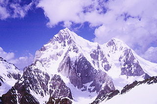
Muztagh Tower, also: Mustagh Tower; Muztagh: ice tower), is a mountain in the Baltoro Muztagh, part of the Karakoram range in Baltistan on the border of the Gilgit–Baltistan region of Pakistan and the Xinjiang Uyghur Autonomous Region of China. It stands between the basins of the Baltoro and Sarpo Laggo glaciers.

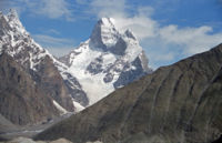
Rakaposhi is a mountain in the Karakoram mountain range of the Gilgit-Baltistan territory of pakistan

Kanjut Sar, or Kunjudh Sar as pronounced in Wakhi, is a mountain located in the Shimshal Valley, part of the Karakoram mountain range. The name Kunjudh Sar in Wakhi means "that which overlooks Kunjudh", or "above Kunjudh", while Khujudh is the Wakhi name for Central Hunza. It is the 28th-highest mountain on Earth and the 11th-highest in Pakistan. According to many residents of Shimshal, Kanjut Sar is the name of the adjacent peak Yukshin Gardan Sar, and vice versa. In Shimshal village, the original namings are widely accepted and used, as opposed to what is recognised internationally.

Chogolisa is a trapezoidal mountain in the Karakoram range in the Gilgit-Baltistan region of Pakistan. It lies near the Baltoro Glacier in the Concordia region, which is home to some of the highest peaks in the world. Chogolisa has several peaks: the highest, on the southwest face, rises to 7,668 metres (25,157 ft); the second-highest at 7,654 metres on the northeast side was named Bride Peak by Martin Conway in 1892.

Tirich Mir is the highest mountain of the Hindu Kush range, and the highest mountain in the world outside of the Himalayas–Karakoram range. It is located in the Chitral District of Khyber Pakhtunkhwa, Pakistan. The first recorded ascent of the mountain was on 21 July 1950 by a Norwegian expedition consisting of Arne Næss, P. Kvernberg, H. Berg, and Tony Streather. Tirich Mir overlooks the town of Chitral, and can be easily seen from the main bazaar. It is the closest mountain to Aconcagua which is higher than Aconcagua, and thus determines Aconcagua's topographic isolation.

Baintha Brakk or The Ogre is a steep, craggy mountain, 7,285 metres (23,901 ft) high, in the Panmah Muztagh, a subrange of the Karakoram mountain range. It is located in Gilgit-Baltistan, Pakistan. It is famous for being one of the hardest peaks in the world to climb: twenty-four years elapsed between the first ascent in 1977 and the second in 2001.
The Buni Zom group is a prominent mountain area of Chitral, in the Hindu Raj range of Pakistan. Buni Zom (main) is the highest peak of the group with an elevation of 6,542 m (21,463 ft). It is located about 50 km (30 mi) northeast of the town of Chitral, and about 50 km (30 mi) east of Tirich Mir, the highest peak in the Hindu Kush.

Falak Sar is the highest mountain peak in Ushu Valley of Swat, Pakistan at an elevation of 5,957 metres (19,544 ft), it is considered the highest peak of the Swat district in the Hindu Kush mountains range, followed by Mankial mountain peak.

Batura Sar, also referred to as Batura I, is the 25th-highest mountain on Earth and the 10th-highest in Pakistan. It is the highest peak of the Batura Muztagh, which is the westernmost subrange of the Karakoram range. It forms the apex of the Batura Wall, a continuously high part of the backbone of the Batura Muztagh.

Mount Sikaram is a mountain on the Afghanistan–Pakistan border, south of the Kabul River and Khyber Pass. At 4,755 m (15,600 ft), it is the highest peak of the Spīn Ghar, or Safēd Kōh, mountain range.
Mamostong Kangri or Mamostang Kangri, surveyed as K35, is the highest peak in the remote Rimo Muztagh, a subrange of the Karakoram range in Ladakh union territory of India. It is located about 30 km east-southeast of the snout of the Siachen Glacier. It is the 48th-highest independent peak in the world.

Gilgit-Baltistan has been under Pakistan administration since 1947 and was given self-governing status on August 29, 2009. Gilgit-Baltistan comprises 10 districts within three divisions. The four districts of Skardu Kharmang Shigar and Ghanche are in the Baltistan Division, four districts of Gilgit Ghizer Hunza and Nagar districts which were carved out of Gilgit District are in the Gilgit Division and the third division is Diamir, comprising Chilas and Astore. The main political centres are the towns of Gilgit and Skardu.

Koyo Zom is the highest peak in the Hindu Raj mountain range in Pakistan at 6,872 metres (22,546 ft). The Hindu Raj mountain range sits between the Hindu Kush in the west and the Karakoram in the east.

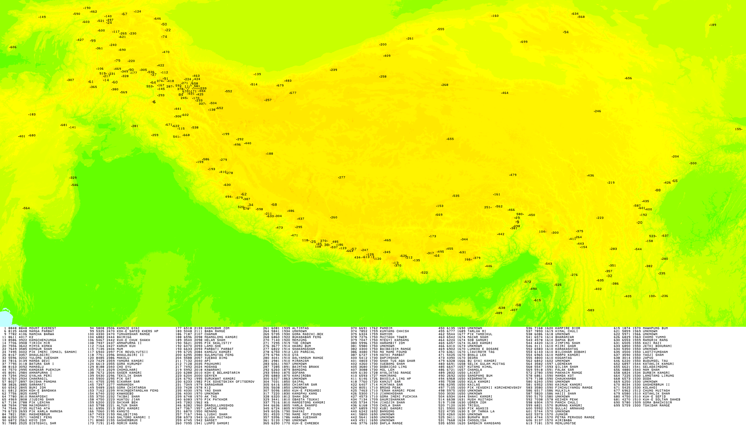
An ultra-prominent peak, or Ultra for short, is a mountain summit with a topographic prominence of 1,500 metres (4,900 ft) or more; it is also called a P1500. The prominence of a peak is the minimum height of climb to the summit on any route from a higher peak, or from sea level if there is no higher peak. There are approximately 1,524 such peaks on Earth. Some well-known peaks, such as the Matterhorn and Eiger, are not Ultras because they are connected to higher mountains by high cols and therefore do not achieve enough topographic prominence.
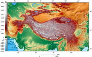
High-Mountain Asia (HMA) is a high-elevation geographic region in Asia that includes numerous cordillera and highland systems around the Tibetan Plateau, encompassing regions of East, Southeast, Central and South Asia. The region was orogenically formed by the continental collision of the Indian Plate into the Eurasian Plate.

