
Uttaradit is one of Thailand's seventy-six provinces (changwat). It lies in upper northern Thailand. Neighboring provinces are Phitsanulok, Sukhothai, Phrae and Nan. To the east it borders Xaignabouli of Laos. Uttaradit is 488 km north of Bangkok, and 238 km southeast of Chiang Mai.

The Phu Phan mountains are a range of hills dividing the Khorat Plateau of the Isan region of Thailand into two basins: the northern Sakhon Nakhon Basin, and the southern Khorat Basin.
Phu Hin Rong Kla National Park is a national park located in the Loei and Phitsanulok Provinces of Thailand. The protected area is located in the forested mountains of the Luang Prabang Range close to the border with Laos and is part of the Luang Prabang montane rain forests ecoregion. The park was the base of operations of the long fight of Thai combatant in communist war of Thailand.
Doi Phu Kha National Park covers parts of 8 districts in the Luang Prabang Range, Nan Province, Northern Thailand and has rich natural resources. It is Northern Thailand's largest National park and rivers such as Nan River and Pua River, have their sources within the area of the range under the protection of the park limits. Khun Nan National Park is located north of the park area.
Phou Khe is a mountain in Southeast Asia, part of the Luang Prabang Range (ทิวเขาหลวงพระบาง).
Utricularia phusoidaoensis is a terrestrial lithophytic carnivorous plant that belongs to the genus Utricularia. It is endemic to the northern Thailand province of Phitsanulok on Phu Soi Dao, where it is only known from the type locality. It grows on wet cliffs at altitudes around 2,000 m (6,562 ft). It is related to U. garrettii, another species endemic to Thailand that shares a similar seed morphology. Utricularia phusoidaoensis is easily distinguished by its purple 4-6-lobed corolla, reniform leaves, and the staghorn-like trap appendages. It has been found growing in the presence of U. spinomarginata. It was first formally described by Piyakaset Suksathan and John Adrian Naicker Parnell in 2010 from collections made by Suksathan in 2007.
Utricularia spinomarginata is a terrestrial lithophytic carnivorous plant that belongs to the genus Utricularia. It is endemic to the northern Thailand province of Phitsanulok on Phu Soi Dao, where it is only known from the type locality. It grows on wet cliffs at altitudes around 2,000 m (6,562 ft). Utricularia spinomarginata is easily distinguished from other members of section Phyllaria by its deeply dissected yellow-white to pink-white 5-lobed corollas and the marginal spine-like hairs on the obovoid seeds. It has been found growing in the presence of U. phusoidaoensis. It was first formally described by Piyakaset Suksathan and John Adrian Naicker Parnell in 2010 from collections made by Suksathan in 2007.
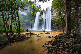
Phu Chong–Na Yoi National Park is a protected area at the eastern end of the Dângrêk Mountains, northeastern Thailand. It is in Buntharik, Na Chaluai, and Nam Yuen districts of Ubon Ratchathani Province. Established in 1987, it is an IUCN Category II protected area, measuring 428,750 rai ~ 686 square kilometres (265 sq mi). In a mountainous area, the park borders Laos and Cambodia. Natural features include the cliffs at Pha Phueng, and the 40 metres (130 ft) Bak Teo Yai Waterfall. In 2004, a specimen of a new frog species, Fejervarya triora, was discovered in the park.

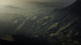
The Luang Prabang Range, named after Luang Prabang, is a mountain range straddling northwestern Laos and Northern Thailand. Most of the range is located in Sainyabuli Province (Laos), as well as Nan and Uttaradit Provinces (Thailand), with small parts in Phitsanulok and Loei Provinces. Several rivers such as the Nan, Pua and Wa rivers, have their sources in this range. Phu Fa waterfall, the biggest and the tallest waterfall in Nan Province, is also located in these mountains. This range is part of the Luang Prabang montane rain forests ecoregion.
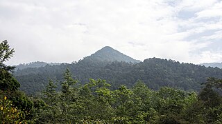
Phu Soi Dao National Park named after 2,120 metres (6,960 ft) high Phu Soi Dao mountain, is a protected area at the southern end of the Luang Prabang Range in the Thai/Lao border area, on the Thai side of the range. It is located in Ban Khok and Nam Pat Districts of Uttaradit Province and Chat Trakan District of Phitsanulok Province. The park was established as Thailand's 109th national park in 2008.
Doi Phu Kha is a mountain that is part of the Luang Prabang Range (ทิวเขาหลวงพระบาง) in Southeast Asia.

Phu Sang National Park is a national park in Northern Thailand.
Phu Chi Fa, also Phu Chee Fah, is a mountain area and national forest park in Thailand. It is located at the northeastern end of the Phi Pan Nam Range, 12 km to the southwest of Doi Pha Tang at the eastern edge of Tap Tao in Thoeng District, Chiang Rai Province.

The Phu Langka Forest Park, or Phu Lang Ka Forest Park, is a protected area of the Phi Pan Nam Range located in Chiang Kham District and Pong District, Phayao Province, Thailand. The park was established on May 8, 2002, and covers an area of 12.48 km2 (4.82 sq mi).

Phu Kao–Phu Phan Kham National Park is a national park in Thailand's Khon Kaen and Nong Bua Lamphu provinces. This mountainous park, in two separate sections, encompasses part of the Ubol Ratana Dam reservoir and also features rock formations and waterfalls. The park is named for the Phu Kao and Phu Phan Kham mountain ranges of the Khorat Plateau.
Phu Khi Suk, known in Khmer as Phnom Dângrêk is a 753-metre-high (2,470 ft) mountain in Ubon Ratchathani Province, Thailand.

The Luang Prabang montane rain forests ecoregion covers elevations over 800 meters in the Luang Prabang mountains that straddle the border between northern Thailand and north-central Laos, and the highlands that stretch eastward across north-central Laos. While much of the forest cover has been degraded, there are still large areas of relatively untouched forest.
Phu Miang—Phu Thong Wildlife Sanctuary is a wildlife sanctuary in Chat Trakan District of Phitsanulok Province and Nam Pat District of Uttaradit Province of Thailand. The sanctuary covers an area of 696 square kilometres (269 sq mi) and was established in 1977.

