Phu Xai Lai Leng

Last updated
Phu Xai Lai Leng
Laos relief map.svg
Red triangle with thick white border.svg
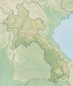
Phu Xai Lai Leng
Location in Laos, on the Vietnam border
Highest point
Elevation 2,720 m (8,920 ft)
Prominence 1,623 m (5,325 ft)
Listing Ultra
Coordinates 19°12′N104°11′E / 19.200°N 104.183°E / 19.200; 104.183
Geography
Location LaosVietnam border
Parent range Annamite Range
Climbing
First ascent Unknown

Phu Xai Lai Leng is a mountain of the Annamite Range in Southeast Asia. It is 2,720 metres tall and sits on the international border between Laos and Vietnam. It is one of the ultra prominent peaks of Southeast Asia. [1]

See also

Related Research Articles

<span class="mw-page-title-main">Phnom Aural</span>

Phnom Aural, also spelled Phnom Aoral, is the tallest peak in Cambodia. It is 1,813 meters tall. It is in the eastern part of the Cardamom Mountains.

Daxue Mountain is a high mountain in Yongde County, Yunnan, China. It is located west of China National Highway 323, about 50 km to the northwest of Lincang.

Bumhpa Bum is one of the highest mountains in Myanmar and is located in the Kachin Hills.

<span class="mw-page-title-main">Ultra-prominent peak</span> Mountain with prominence of 1,500 metres

An ultra-prominent peak, or ultra for short, is a mountain summit with a topographic prominence of 1,500 metres (4,900 ft) or more; it is also called a P1500. The prominence of a peak is the minimum height of climb to the summit on any route from a higher peak, or from sea level if there is no higher peak. There are approximately 1,524 such peaks on Earth. Some well-known peaks, such as the Matterhorn and Eiger, are not ultras because they are connected to higher mountains by high cols and therefore do not achieve enough topographic prominence.

Ayribobo is a mountain in Central Asia. At 3,138 metres (10,295 ft) Ayribobo is the highest mountain in Turkmenistan. It is located in the Köýtendag Range of the Pamir-Alay chain in the southeast of Turkmenistan on the Uzbekistan border.

Mol Len is a mountain in Southeast Asia. Rising to 3,088 metres (10,131 ft), it is located at the mountainous border of Nagaland state of India and the Sagaing Region of Burma. Mol Len is considered to be one the ultra prominent peaks in Southeast Asia.

Phou Khe is a mountain in Southeast Asia, part of the Luang Prabang Range (ทิวเขาหลวงพระบาง).

Rào Cỏ mountain is a mountain in Southeast Asia. It is one of the ultra prominent peaks of Southeast Asia. The mountain is 2,286 metres tall and sits on the international border between Laos and Vietnam.

Loi Pangnao is the highest mountain of the Daen Lao Range, a subrange of the Shan Hills. It is located near Mong Yawng in Shan State, Burma close to the border with China.

<span class="mw-page-title-main">Loi Leng</span>

Loi Leng is the highest mountain of the Shan Hills. It is located in Shan State, Burma, 45 kilometres (28 mi) to the southeast of Lashio.

Mong Ling Shan, also known as Möng Ling Shan, is one of the highest mountains of the Shan Hills. It is located in the Namtit Special District of Wa State, Myanmar close to the border with China and 122 km to the ENE of Lashio. It is the highest peak in Myanmar Shan State.

Mela Taung is the highest mountain of the Dawna Range. It is located in Kayin State, Burma, close to the border with Thailand.

Nattaung is the highest mountain of the Karen Hills. It is located in the border area between Kayin State and Kayah State, Burma, 72 kilometres (45 mi) to the west from the border with Thailand. With a height of 2,623 metres (8,606 ft) and a prominence of 1,726 metres (5,663 ft), Nattaung is one of the ultra prominent peaks of Southeast Asia.

Myinmoletkat Taung is the highest mountain in Myanmar Tanintharyi Region. Located on the Bilauktaung, Tenasserim Hills, Burma.

Sangpang Bum is one of the highest mountains of the Northern Triangle of Burma. It is located in the Sagaing Region, Burma.

Saramati is a peak rising above the surrounding peaks at the mountainous border of the Indian state of Nagaland and the Naga Self-Administered Zone of the Sagaing Region of Myanmar. It is located near the village of Thanamir in the Kiphire District of Nagaland.

Mawhpung Bum or Mawhpungbum is a conspicuous mountain of the Sagaing Region, Burma. It is located near the border with Kachin State.

Hunhua Shan, also named Lincang Daxueshan 临沧大雪山, is a high mountain in Yunnan, China. It is located east of China National Highway 323, about 15 km to the northeast of Lincang.

Mount Benum or Mount Benom is a mountain in the state of Pahang in Malaysia. Its summit is 2,107 m (6,913 ft) above sea level. The mountain is located in a centre of a massif east of the Titiwangsa Mountains.

References