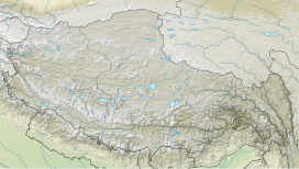
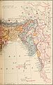
Arunachal Pradesh is a state in northeast India. It was formed from the North-East Frontier Agency (NEFA) region, and India declared it as a state on 20 February 1987. Itanagar is its capital and largest town. It borders the Indian states of Assam and Nagaland to the south. It shares international borders with Bhutan in the west, Myanmar in the east, and a disputed 1,129 km border with China's Tibet Autonomous Region in the north at the McMahon Line. Arunachal Pradesh is claimed by China as South Tibet as part of the Tibet Autonomous Region; China occupied some regions of Arunachal Pradesh in 1962 but later withdrew its forces.
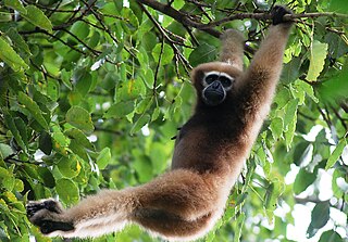
The hoolock gibbons are three primate species of genus Hoolock in the gibbon family, Hylobatidae, native to eastern Bangladesh, Northeast India, Myanmar, and Southwest China.

Dibang Valley (Pron:/dɪˈbæŋ/) is a district of Arunachal Pradesh named after the Dibang River or the Talon as the Mishmis call it. It is the least populated district in India and has an area of 9,129 square kilometres (3,525 sq mi).

Lohit is an administrative district in the state of Arunachal Pradesh in India. The district headquarters is located at Tezu. As of 2011 it is the third most populous district of Arunachal Pradesh, after Papum Pare and Changlang.

West Siang district is an administrative district in the state of Arunachal Pradesh in India.
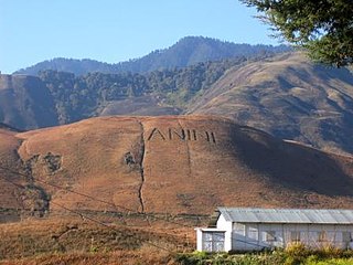
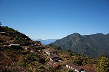
Anini is the headquarters of the Dibang Valley district in the state of Arunachal Pradesh in Northeast India. Anini was also the district headquarters of the undivided Dibang Valley district. Most of this location's population consists of the Idu Mishmi tribal people. Due to its remote location, Anini remains a small and underdeveloped town. However, it still has basic road and air links to the rest of India. The town is fully dependent on the nearest major settlement, Roing, which is in the Lower Dibang Valley District, for most commercial needs.

Walong is an administrative town and the headquarters of eponymous circle in the Anjaw district in eastern-most part of Arunachal Pradesh state in India. It also has a small cantonment of the Indian Army. Walong is on banks of Lohit River, which enters India 35 km north of Walong at India-China LAC at Kaho pass.
Sadiya is a town in Tinsukia district, Assam. It was the capital of the Chutia Kingdom and after the downfall of the kingdom it became the seat of the Sadiya-khowa-Gohain of the Ahom kingdom. Extensive remains of buildings and fortifications built during the rule of the Chutias near Sadiya still point to the importance of the region in the past. Historically Sadiya referred to the Chutiya kingdom which included at times the districts of Lakhimpur, Dhemaji and Tinsukia. It is claimed to be the center of development of the eastern Assamese dialects, the inscription here are written in a Tai script. Its stands on a grassy plain, almost surrounded by forested Himalayan mountains, on the right bank of Lohit River which is locally considered the main stream of the Brahmaputra River. The deepest point of the Brahmaputra River is located near this village. It is famous for a flower named satphul, which is much like Jasmine.

Namdapha National Park is a 1,985 km2 (766 sq mi) large protected area in Arunachal Pradesh of Northeast India. The park was established in 1983. With more than 1,000 floral and about 1,400 faunal species, it is a biodiversity hotspot in the Eastern Himalayas. The national park harbours the northernmost lowland evergreen rainforests in the world at 27°N latitude. It also harbours extensive dipterocarp forests, comprising the northwestern parts of the Mizoram-Manipur-Kachin rain forests ecoregion.

Anjaw District (Pron:/ˈændʒɔ:/) is an administrative district in the state of Arunachal Pradesh in north-east India. It was created district in 2004, by splitting off from the Lohit district under the Arunachal Pradesh Re-organization of Districts Amendment Act. The district borders China on the north. Hawai, at an altitude of 1296 m above sea level, is the district headquarters, located on the banks of the Lohit River, a tributary of the Brahmaputra River. It is the easternmost district in India. The furthest villages towards the border with China are Dong, Walong, Kibithu and Kaho.

The Lower Dibang Valley district (Pron:/dɪˈbæŋ/) is an administrative district in the state of Arunachal Pradesh in northeastern India. It is the tenth least populous district in the country.
Dihang-Dibang or Dehang-Debang is a biosphere reserve constituted in 1998. It is in the Indian state of Arunachal Pradesh. The Mouling National Park and the Dibang Wildlife Sanctuary are located fully or partly within this biosphere reserve. The reserve spreads over three districts: Dibang Valley, Upper Siang, and West Siang. It covers high mountains of Eastern Himalaya and Mishmi Hills. The elevation in the reserve ranges up to more than 5,000 metres (16,000 ft) above sea level. An important fact relating to this Biosphere reserve is that it has natural vegetation stretching in an unbroken sequence from the tropics to mountain tundra. The type of vegetation are found in this biosphere reserve can be grouped as 1. Sub-tropical broad leafed forests, 2. Sub tropical pine forest, 3. Temperate broad leafed forests, 4. Temperate conifer, 5. Sub-alpine woody shrub, 6. Alpine meadow( mountain Tundra), 7. Bamboo brakes, 8. Grassland. The habitat in Dihang-Dibang ranges from tropical wet evergreen in the river gorges to subtropical, temperate, alpine and permanent snow.
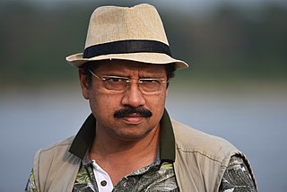
Anwaruddin Choudhury is an Indian naturalist, noted for his expertise on the fauna of North-East India.

The Dibang Wildlife Sanctuary is one of the eight wildlife sanctuaries of Arunachal Pradesh, India.

Dehing Patkai National Park is a national park in the Dibrugarh and Tinsukia districts of Assam covering an area of 231.65 km2 (89.44 sq mi) of rainforest. It was declared a wildlife sanctuary on 13 June 2004. On 13 December 2020, the Government of Assam upgraded it into a national park. On 9 June 2021, the Forest Department of Assam officially notified it as a national park. It is located in the Dehing Patkai Landscape which is a dipterocarp-dominated lowland rainforest. The rainforest stretches for more than 575 km2 (222 sq mi) in the districts of Dibrugarh, Tinsukia and Charaideo. The forest further spreads over in the Tirap and Changlang districts of Arunachal Pradesh. Dehing Patkai National Park harbours the largest stretch of lowland rainforests in India. Dehing Patkai Wildlife Sanctuary was declared as Dehing Patkai Elephant Reserve under Project Elephant. Dehing-Patkai as a potential wildlife sanctuary was identified in late 1980s during a primate survey as "Upper Dehing Wildlife Sanctuary". Subsequently during a study on white-winged wood duck in early 1990s, it was discovered as a globally important site for this duck and recommended to be upgraded to "Upper Dehing National Park".
BARAIL Wildlife Sanctuary is located in the southern part of Assam, India, in the Cachar district, and lies between 24°55΄53΄΄-25°05΄52΄΄ N latitude and 92°27΄40΄΄-93°04΄30΄΄ E longitude. The Dima Hasao part of Barail is not part of this sanctuary. The altitude ranges between 55–1500 m above mean sea level. It spreads over 326.24 km2. The annual average rainfall and temperature range from 2500–4000 mm and 9.2 °C to 36.2 °C respectively; the humidity varies from 62% to 83%. Fieldworks in the Barail area were proposed as a national park or sanctuary in the 1980s.

Arunachal Pradesh is primarily a hilly tract nestled in the foothills of the Himalayas in northeast India. It is spread over an area of 83,743 km2 (32,333 sq mi). 98% of the geographical area is land out of which 80% is forest cover; 2% is water. River systems in the region, including those from the higher Himalayas and Patkoi and Arakan Ranges, eventually drain into the Brahmaputra River.

The Kamlang Wildlife Sanctuary, established in 1989, is the 50th Tiger reserve in India. The Sanctuary is rich with floral and faunal diversity. It is situated in the Lohit District of the northeastern Indian state of Arunachal Pradesh. The park is named after the Kamlang River which flows through it. The Mishmi, Digaro Mishmi, and Miju Mishmi people tribal people who reside around the periphery of the sanctuary claim their descent from the King Rukmo of the epic Mahabharata. They believe in a myth of an invisible god known as Suto Phenkhenynon jamalu. An important body of water in the sanctuary is the Glow Lake. Located in tropical and sub-tropical climatic zones, the sanctuary is the habitat of the four big cat species of India: tiger, leopard, clouded leopard and snow leopard.
Khonoma Nature Conservation and Tragopan Sanctuary or KNCTS is a conservation reserve and a protected area in the Kohima District of the state of Nagaland in India. It is about 18 kilometres (11 mi) west of the capital of Nagaland, Kohima. The total area notified under this park is around 25 square kilometres (9.7 sq mi); some of villages and hamlets are adjacent to this park: Khonoma, Mezoma and Dzüleke. The sanctuary is home to several endangered mammal species, including the clouded leopard, Asiatic black bear, and hoolock gibbon, as well as over 300 avian species.
The Mishmi giant flying squirrel is a species of rodent in the family Sciuridae. First described in 2009 from East Himalayan forests at altitudes of 600–1,600 m (2,000–5,200 ft) in the Mishmi Hills of northeastern Arunachal Pradesh in India, the taxonomic status and position of this giant flying squirrel is not fully resolved.