Kedarnath (mountain)

Last updated

Kedarnath
Mt. Kedarnath.jpg
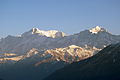
The first rays of sunlight falling on Mt. Kedarnath.
Highest point
Elevation 6,940 m (22,770 ft) [1]
Prominence 1,400 m (4,600 ft) [2]
Coordinates 30°47′42″N79°04′10″E / 30.79500°N 79.06944°E / 30.79500; 79.06944 Coordinates: 30°47′42″N79°04′10″E / 30.79500°N 79.06944°E / 30.79500; 79.06944 [1]
Geography
Location Uttarakhand, India
Parent range Gangotri Group, Garhwal Himalaya
Climbing
First ascent 1947 by André Roch et al. [3]

Kedarnath (or Kedarnath Main) and Kedarnath Dome (or Kedar Dome) are two mountains in the Gangotri Group of peaks in the western Garhwal Himalaya in Uttarakhand state, India. Kedarnath (Main) lies on the main ridge that lies south of the Gangotri Glacier, and Kedarnath Dome, a subpeak of the main peak, lies on a spur projecting towards the glacier, two kilometres northwest of Kedarnath. They are at a distance 15 kilometres (9 mi) south of the Hindu holy site of Gaumukh (the source of the Ganges River). Kedarnath is the highest peak on the south side of the Gangotri Glacier, and Kedarnath Dome is the third highest. [3]

Contents

Kedarnath peak and Kedarnath dome Kedarnath peak and Kedarnath dome.jpg
Kedarnath peak and Kedarnath dome
Kedarnath Dome
Highest point
Elevation 6,831 m (22,411 ft) [1]
Prominence 100 m (300 ft) [2]
Coordinates 30°48′31″N79°04′44″E / 30.80861°N 79.07889°E / 30.80861; 79.07889 [1]
Geography
Location Uttarakhand, India
Parent range Gangotri group, Garhwal Himalaya
Climbing
First ascent 1947 by André Roch et al. [3]
Easiest route Northwest flank (glacier/snow climb)

Ascent

Kedarnath and Kedarnath Dome were first climbed together, in 1947, by a Swiss team led by André Roch. Their route on Kedarnath Dome, the northwest flank, is still the standard route; it is straightforward and relatively low-angle, and is a popular ski ascent in the spring season. The east face of Kedarnath Dome was first climbed in 1989 by a Hungarian expedition led by Attila Ozsváth. Their climb involved "sixty pitches of very hard climbing." [3]

See also

Related Research Articles

Gangotri Group

The Gangotri Group of mountains is a subdivision of the Garhwal Himalaya in the northern Indian state of Uttarakhand. It rings the Gangotri Glacier, and contains peaks that are notable either for their religious significance to Hindus, for their difficult climbing routes, or both. Climbs on three of the peaks have resulted in the awarding of the prestigious climbing award, the Piolet d'Or.

Nilkantha (mountain)

Nilkantha is a major peak of the Garhwal division of the Himalayas, in the Uttarakhand region of the Indian state of Uttarakhand. Although substantially lower than the highest peaks of the region, it towers dramatically over the valley of the Alaknanda River and rises 3,474 metres (11,398 ft) above the Hindu pilgrimage site of Badrinath, only 9 km (6 mi) to the east. Frank Smythe described the peak as "second only to Siniolchu in Himalayan beauty."

Swargarohini Mountain massif in Uttarakhand, India

Swargarohini is a mountain massif in the Saraswati (Bandarpunch) Range of the Garhwal Himalaya. It lies in the Uttarkashi District of the northern Indian state of Uttarakhand, west of the Gangotri group of peaks. It comprises four separate peaks: Swargarohini I is the main peak, and is the subject of this article. While not particularly high by Himalayan standards, and not the highest in the Bandarpunch range, Swargarohini I is notable for its dramatic local relief. For example, its north face drops 2,000 metres (6,560 ft) in less than 2 kilometres (1.2 mi) of horizontal distance, and its south face achieves the same drop in less than 3 kilometres (1.9 mi). This makes it a steep and challenging climb. Swargarohini I has two summits, east and west. The east summit is given an elevation of 6,247 m (20,495 ft), slightly lower than the west summit. However the first ascensionists of the west summit claim that that summit is the higher of the two.

Shivling (mountain)

Shivling is a mountain at tapovan in the Gangotri Group of peaks in the western Garhwal Himalaya, near the snout of the Gangotri Glacier. It lies in the northern Indian state of Uttarakhand, 6 kilometres (4 mi) south of the Hindu holy site of Gaumukh. Its name refers to its status as a sacred symbol -Shiva Linga. It was called "Matterhorn Peak" by early European visitors because of its similarity in appearance to that Alpine peak. While not of locally great elevation, it is a dramatic rock peak, and most visually striking peak seen from Gaumukh; that and the difficulty of the climb make it a famed prize for mountaineers.

Thalay Sagar

Thalay Sagar is a mountain in the Gangotri Group of peaks in the western Garhwal Himalayas, on the main ridge that lies south of the Gangotri Glacier. It lies in the northern Indian state of Uttarakhand, 10 kilometres (6 mi) southwest of the Hindu holy site of Gaumukh. It is the second highest peak on the south side of the Gangotri Glacier, but it is more notable for being a dramatic rock peak, steep on all sides, and a famed prize for mountaineers. It is adjacent to the Jogen group of peaks, and has the lake Kedartal at its base.

Chaukhamba Mountain in India

Chaukhamba is a mountain massif in the Gangotri Group of the Garhwal Himalaya. Its main summit, Chaukhamba I, is the highest peak in the group. It lies at the head of the Gangotri Glacier and forms the eastern anchor of the group. It is located in the northern Indian state of Uttarakhand, west of the Hindu holy town of Badrinath.

Panch Kedar A group of five Shiva Temples in Uttarakhand, India.

Panch Kedar refers to five Hindu temples or holy places of the Shivaite sect dedicated to god Shiva. They are located in the Garhwal Himalayan region in Uttarakhand, India. They are the subject of many legends that directly link their creation to Pandavas, the heroes of the Hindu epic Mahabharata.

Auden's Col is a high altitude mountain pass connecting Rudugaira valley and Bhilangna valley. It is situated at 5,490 metres (18,010 ft) elevation and connects the ridge coming from Gangotri III peak on the north-west and the ridge coming from Jogin I on the east, and also binds a glacier coming from Jogin I on the north side of Rudugaira valley, and deadly Khatling glacier on the south side of Bhilangna valley.

Bhrigupanth Mountain in Uttarakhand, India

Bhrigupanth is a mountain of Garhwal Himalaya in Uttarakhand India. It stands majestically at 6772 meter 22218 feet. It is the 38th highest located entirely within the Uttrakhand India. Nanda Devi is the highest mountain in this category. Bhrigupanth is the 525th highest peak in the world. It is located northeast of Thalay Sagar 6904 meter, northwest of Meru Peak 6660 meter and south of Manda III 6529 meter.

Chandra Parbat I Mountain in Uttarakhand, India

Chandra Parbat I is a mountain of the Garhwal Himalaya in Uttarakhand, India. Chandra Parbat I standing majestically at 6,739 metres (22,110 ft). It is 42nd highest located entirely within the Uttrakhand. Nanda Devi, is the highest mountain in this category. Chandra Parbat I lies on the eastern bank of the Suralaya Glacier. It is located in between Chandra II and Chandra III (South). It is located 4.9 km NE of Satopanth 7,075 metres (23,212 ft) and 8 km west lies Vasuki South 6,702 metres (21,988 ft). On the 7.4 km SWS lies the Swachhand Peak 6,721 metres (22,051 ft) and Bhgirathi Massif on the west side.

Kharchakund Mountain in Uttarakhand, India

Kharchakund is a mountain of the Garhwal Himalaya in Uttarakhand, India. The elevation of Kharchakund is 6,612 metres (21,693 ft) and its prominence is 835 metres (2,740 ft). It is 64th highest located entirely within the Uttrakhand. Nanda Devi, is the highest mountain in this category. It is surrounded by Gangotri Glacier and Ghanoim Bamak. Its nearest higher neighbor Kedarnath Dome 6,831 metres (22,411 ft) lies 6.4 km WNW. It is located 1.2 km NNE of Sumeru Parbat 6,351 metres (20,837 ft) and 10.7 km east lies Janhukut 6,829 metres (22,405 ft).

Kirti Stambh (mountain) Mountain in Uttarakhand, India

Kirti Stambh is a mountain of the Garhwal Himalaya in Uttarakhand India.The elevation of Kirti Stambh is 6,270 metres (20,571 ft) and its prominence is 100 metres (328 ft). It is 128th highest located entirely within the Uttrakhand. Nanda Devi, is the highest mountain in this category. It lies between Thalaysagar and Bhartekunta. Its nearest higher neighbor Bhartekunta 6,578 metres (21,581 ft) lies 2.3 km SE. It is located 5.1 km SSE of Thalaysagar 6,904 metres (22,651 ft) and 12.8 km NEE lies Bhagirathi I 6,856 metres (22,493 ft).

Bharte khunta Mountain in Uttarakhand, India

Bharte khunta is a mountain of the Garhwal Himalaya in Uttarakhand India.The elevation of Bharte khunta is 6,578 metres (21,581 ft) and its prominence is 280 metres (919 ft). It is 69th highest located entirely within the Uttrakhand. Nanda Devi, is the highest mountain in this category. It lies between Kirti Stambh and Kedarnath (mountain). Its nearest higher neighbor Kedarnath (mountain) 6,940 metres (22,769 ft) lies 3 km ESE. It is located 2.3 km SE of Kirti Stambh 6,279 metres (20,600 ft) and 6.9 km north lies Meru Peak 6,660 metres (21,850 ft).

Mandani Parbat Mountain in Uttarakhand, India

Mandani Parbat is a mountain of the Garhwal Himalaya in Uttarakhand India.The elevation of Mandani Parbat is 6,193 metres (20,318 ft) and its prominence is 535 metres (1,755 ft). It is joint 140th highest located entirely within the Uttrakhand. Nanda Devi, is the highest mountain in this category. It lies between Chaukhamba IV, 6,854 metres (22,487 ft) and Sumeru Parbat, 6,351 metres (20,837 ft). Its nearest higher neighbor Chaukhamba IV lies 5.5 km east. It is located 8.4 km SE of Sumeru Parbat and 6.5 km NE lies Janhukut 6,829 metres (22,405 ft).

Satopanth south west Mountain in Uttarakhand, India

Satopanth south west also called P. 6770 is a mountain of the Garhwal Himalaya in Uttarakhand, India. The elevation of Satopanth south west is 6,770 metres (22,211 ft) and its prominence is 195 metres (640 ft). It is 40th highest located entirely within the Uttrakhand. Nanda Devi, is the highest mountain in this category. It lies in the same connecting ridge that joins Satopanth and Bhagirathi Parbat I. It lies 1.8 km SW of Satopanth. Its nearest higher neighbor Satopanth 7,075 metres (23,212 ft). It is located 3.4 km SE of Vasuki South 6,702 metres (21,988 ft) and 5.2 km NNW lies Bhagirathi I 6,856 metres (22,493 ft).

Jogin I Mountain in Uttarakhand, India

Jogin I is a mountain of the Garhwal Himalaya in Uttarakhand India.The elevation of Jogin I is 6,465 metres (21,211 ft) and its prominence is 843 metres (2,766 ft). It is 94th highest located entirely within the Uttrakhand. Nanda Devi, is the highest mountain in this category. It lies 5.4 km east of Gangotri III and 7.4 km west of Bhrigupanth 6,772 metres (22,218 ft). It lies 2.2 km South of Jogin II. Its nearest higher neighbor is Gangotri III 6,577 metres (21,578 ft). It is located 6.9 km NW of Thalaysagar 6,904 metres (22,651 ft) and 8.8 km NW lies Gangotri I 6,682 metres (21,923 ft).

Jogin III Mountain in Uttarakhand, India

Jogin III is a mountain of the Garhwal Himalaya in Uttarakhand, India. The elevation of Jogin III is 6,116 metres (20,066 ft). It is 155th highest located entirely within the Uttrakhand. Nanda Devi, is the highest mountain in this category.

Manda III Mountain in Uttarakhand, India

Manda III is a mountain of the Garhwal Himalaya in Uttarakhand India. The elevation of Manda III is 6,529 metres (21,421 ft) and its prominence is 450 metres (1,476 ft). It is joint 81st highest located entirely within the Uttrakhand. Nanda Devi, is the highest mountain in this category. It lies 2.4 km south of Manda II 6,568 metres (21,549 ft) and 2.8 km north of Bhrigupanth 6,772 metres (22,218 ft). It lies 6.6 km east of Jogin II 6,342 metres (20,807 ft). It is located 6.7 km NW of Shivling (mountain) 6,543 metres (21,467 ft) and 13.1 km east lies Bhagirathi Parbat II 6,512 metres (21,365 ft).

Vasuki Parbat South Mountain in Uttarakhand, India

Vasuki Parbat South is a mountain of the Garhwal Himalaya in Uttarakhand, India. The elevation of Vasuki Parbat South is 6,702 metres (21,988 ft) and its prominence is 280 metres (919 ft). It is 49th highest located entirely within the Uttrakhand. Nanda Devi, is the highest mountain in this category. It lies 1.6 km south of Vasuki Parbat its nearest higher neighbor 6,792 metres (22,283 ft) and 2.7 km east of Bhagirathi Parbat I 6,856 metres (22,493 ft). It is located 4.6 km SE of Bhagirathi Parbat II 6,512 metres (21,365 ft) and 4.1 km SE lies Satopanth 7,075 metres (23,212 ft).

P. 6504 Mountain in Uttarakhand, India

P. 6504 is a mountain of the Garhwal Himalaya in Uttarakhand, India. It is also known as Satopanth West. It is situated in the Gangotri National Park. The elevation of P. 6504 is 6,504 metres (21,339 ft). It is joint 88th highest located entirely within the Uttrakhand. Nanda Devi, is the highest mountain in this category. It lies 3 km SSE of Bhagirathi Parbat I 6,856 metres (22,493 ft). Satopanth 7,075 metres (23,212 ft) lies 5.8 km ENE and it is 6.7 km WNW of Swachhand 6,721 metres (22,051 ft). It lies 8.1 km ENE of Kedarnath Dome 6,831 metres (22,411 ft).

References

  1. 1 2 3 4 H. Adams Carter, "Classification of the Himalaya", American Alpine Journal , 1985, p. 140.
  2. 1 2 Corrected version of SRTM data, available at Viewfinder Panoramas
  3. 1 2 3 4 Andy Fanshawe and Stephen Venables, Himalaya Alpine-Style, Hodder and Stoughton, 1995, ISBN   0-340-64931-3, p. 106.