List of Himalayan peaks and passes

Last updated

The Karakoram and Hindu Kush are regarded as separate ranges. In the table below sorting by coordinates sorts by longitude (i.e. West to East) and "HP" = High point.

Contents

Peaks

Global RankPeaksOther names and meaningElevationProminence
(metres)
IsolationRegionCoordinatesCountry (disputed claims in italics)First
Ascent
Notes
cmin
1 Mount Everest Sagarmatha, Chomolungma8,848.8629,0328,848infinite Mahalangur 27°59′17″N86°55′31″E / 27.98806°N 86.92528°E / 27.98806; 86.92528 (1. Mount Everest / Sagarmatha / Chomolungma (8848 m)) China   Nepal 1953Highest peak in the world [1]
2 K2 Godwin Austin, Chhogori "Savage Mountain"8,61128,2514,020136Karakoram 35°52′57″N76°30′48″E / 35.88250°N 76.51333°E / 35.88250; 76.51333 (2. K2 (8611 m)) Pakistan   China [2] [dp 1] 1954Second highest peak in the world [3]
3 Kanchenjunga "Five treasures of great snow"8,58628,1693,922124.3Nepal/India 27°42′12″N88°08′51″E / 27.70333°N 88.14750°E / 27.70333; 88.14750 (3. Kangchenjunga (8586 m)) India   Nepal 1955Third highest peak in the world, Easternmost 8000m peak [4]
4 Lhotse "South Peak"8,51627,9406102.7 Mahalangur 27°57′42″N86°55′59″E / 27.96167°N 86.93306°E / 27.96167; 86.93306 (4. Lhotse (8516 m)) Nepal   China 1956Part of Everest massif
5 Makalu "The Great Black"8,48527,8382,37817.2 Mahalangur 27°53′23″N87°05′20″E / 27.88972°N 87.08889°E / 27.88972; 87.08889 (5. Makalu (8485 m)) Nepal   China 1955East of Mt. Everest
6 Cho Oyu "Turquoise Goddess"8,28127,1622,43028.5 Mahalangur 28°05′39″N86°39′39″E / 28.09417°N 86.66083°E / 28.09417; 86.66083 (6. Cho Oyu (8188 m)) Nepal   China 1954Easiest 8000m peak
7 Dhaulagiri I "White Mountain"8,17626,8253,357317.6Central 28°41′48″N83°29′35″E / 28.69667°N 83.49306°E / 28.69667; 83.49306 (7. Dhaulagiri I (8167 m)) Nepal 1960West of Gandaki River
8 Manaslu Kutang, "Mountain of the Spirit","Killer Mountain"8,16326,7813,092105.6Central 28°33′00″N84°33′35″E / 28.55000°N 84.55972°E / 28.55000; 84.55972 (8. Manaslu (8163 m)) Nepal 1956
9 Nanga Parbat Diamir, "Naked Mountain"8,12626,6604,608188.5 Gilgit-Baltistan (GB) region 35°14′14″N74°35′21″E / 35.23722°N 74.58917°E / 35.23722; 74.58917 (9. Nanga Parbat (8126 m)) India [5] [dp 2] 1953Westernmost peak of Himalayas, rises 7000m above Indus River.
10 Annapurna I "Goddess of the Harvests"8,10026,5682,98433.9Central 28°35′44″N83°49′13″E / 28.59556°N 83.82028°E / 28.59556; 83.82028 (10. Annapurna I (8091 m)) Nepal 1950North of Pokhara
14 Shishapangma "Crest above the grassy plains", Gosainthan8,06426,4502,89791.3Central 28°21′12″N85°46′43″E / 28.35333°N 85.77861°E / 28.35333; 85.77861 (14. Shishapangma (8027 m)) Nepal   China 1964About 10 km north of Nepal border.
15 Gyachung Kang Buddha's Peak7,99526,2246727.6 Mahalangur 28°05′53″N86°44′32″E / 28.09806°N 86.74222°E / 28.09806; 86.74222 (15. Gyachung Kang (7952 m)) Nepal   China 1964Highest mountain under 8,000m
16 Nuptse "West Peak" in Tibetan7,95026,0763053.4 Mahalangur 27°57′59″N86°53′24″E / 27.96639°N 86.89000°E / 27.96639; 86.89000 (16. Nuptse (7950 m)) Nepal 1961sub peak of Lhotse
23 Nanda Devi "Bliss-giving Goddess"7,81625,6433,139388.7 Garhwal 30°22′33″N79°58′15″E / 30.37583°N 79.97083°E / 30.37583; 79.97083 (23. Nanda Devi (7925 m)) India 1936HP Uttarakhand. Highest peak entirely within India.
28 Namcha Barwa 7,78225,5314,160707.8 Arunachal Pradesh 29°37′52″N95°03′19″E / 29.63111°N 95.05528°E / 29.63111; 95.05528 (28. Namcha Barwa (7782 m)) India   China 1992Eastern end of Himalaya
29 Kamet 7,75625,4462,82570.3 Garhwal 30°55′12″N79°35′30″E / 30.92000°N 79.59167°E / 30.92000; 79.59167 (29. Kamet (7756 m)) India 1931
34 Gurla Mandhata 7,74425,4002,788127.5West Tibetan 30°26′19″N81°17′48″E / 30.43861°N 81.29667°E / 30.43861; 81.29667 (34. Gurla Mandhata (7694 m)) India   China 1985
40 Gangkhar Puensum Gankar Punzum, "Three Mountain Siblings"7,70025,2563,025228.1Bhutanese 28°02′50″N90°27′19″E / 28.04722°N 90.45528°E / 28.04722; 90.45528 (40. Gangkhar Puensum (7570 m)) Bhutan unclimbedHP Bhutan. World's highest unclimbed peak. Off-limits.
45 Kula Kangri 7,60024,9281,65425.4Bhutanese 28°13′37″N90°36′59″E / 28.22694°N 90.61639°E / 28.22694; 90.61639 (45. Kula Kangri (7538 m)) China ( Bhutan ) [6] 1986
62 Yangra Ganesh I7,50024,6002,35248.1Central 28°23′29″N85°07′38″E / 28.39139°N 85.12722°E / 28.39139; 85.12722 (62. Yangra / Ganesh I (7422 m)) Nepal   China 1955
75 Labuche Kang 7,39624,2591,95738.3Central 28°18′15″N86°21′03″E / 28.30417°N 86.35083°E / 28.30417; 86.35083 (75. Labuche Kang (7367 m)) Nepal   China 1987
78 Jomolhari 7,32624,0352,065106Bhutanese 27°49′36″N89°16′04″E / 27.82667°N 89.26778°E / 27.82667; 89.26778 (78. Jomolhari (7326 m)) Bhutan   China 1937
84 Gyala Peri 7,29423,9302,94220.4 Tibet [7] 29°48′52″N94°58′07″E / 29.81444°N 94.96861°E / 29.81444; 94.96861 (84. Gyala Peri (7294 m)) China [8] 1986
98 Langtang Lirung 7,22523,6981,53424.5Central 28°15′22″N85°31′01″E / 28.25611°N 85.51694°E / 28.25611; 85.51694 (98. Langtang Lirung (7227 m)) Nepal 1978
102 Tongshanjiabu 7,20023,6161,75738.8Bhutanese 28°11′12″N89°57′27″E / 28.18667°N 89.95750°E / 28.18667; 89.95750 (102. Tongshanjiabu (7207 m)) Bhutan   China [9] unclimbed
104 Noijin Kangsang 7,19023,5832,16088.4East Tibetan 28°56′48″N90°10′42″E / 28.94667°N 90.17833°E / 28.94667; 90.17833 (104. Noijin Kangsang / Norin Kang (7206 m)) China [10] 1986
120 Nun 7,13523,4092,404166.7 Kashmir Valley 33°58′48″N76°01′18″E / 33.98000°N 76.02167°E / 33.98000; 76.02167 (Nun) India [dp 3] 1953
148 Kangto 7,06023,1632,195189.6 Arunachal Pradesh 27°51′54″N92°31′57″E / 27.86500°N 92.53250°E / 27.86500; 92.53250 (Kangto) India   China
Machapuchare "Fish Tail"6,99322,94312339.2Central 28°29′42″N83°56′57″E / 28.49500°N 83.94917°E / 28.49500; 83.94917 (Machapuchare) Nepal1957
(short of
summit)
Sacred to Shiva, off-limits.
Dorje Lakpa "Langtang Himal"6,96622,85479615.1Central 28°10′26″N85°46′45″E / 28.17389°N 85.77917°E / 28.17389; 85.77917 (Dorje Lakpa) Nepal1992NW of Kathmandu.
Kedarnath (mountain) "The Great God"6,94022,763102710.3 Himalayas 30°47′42″N79°04′10″E / 30.79500°N 79.06944°E / 30.79500; 79.06944 (Kedarnath (6940m)) India1947
Kedarnath (mountain) "Kedarnath II"6,83122,406102710.3 Himalayas 30°48′31″N79°04′44″E / 30.80861°N 79.07889°E / 30.80861; 79.07889 (Kedarnath Dome (6831m)) India1947
Ama Dablam "Mother And Her Necklace"6,81422,350 Mahalangur 27°51′40″N86°51′40″E / 27.86111°N 86.86111°E / 27.86111; 86.86111 (Ama Dablam (6814m)) Nepal1961
Kangtega "The Snow Saddle"6,78222,251 Mahalangur 27°47′00″N86°49′00″E / 27.78333°N 86.81667°E / 27.78333; 86.81667 (Kangtega (6782m)) Nepal
Mount Kailash Kang Rinpoche (Precious Snow Peak)6,63821,778131966.0West Tibetan [11] 31°4′0″N81°18′45″E / 31.06667°N 81.31250°E / 31.06667; 81.31250 (Mount Kailash) NepalUnclimbedSacred to four religions, near sources of four major rivers.
Mana Peak "Manaswini"6,56121,520 Himalayas 31°05′13″N79°27′06″E / 31.08694°N 79.45167°E / 31.08694; 79.45167 (Manasvini/Mana Peak (6561m)) India1972
Bandarpunch "Mahalangur Hanuman"6,49821,313 Mahalangur 30°47′42″N79°04′10″E / 30.79500°N 79.06944°E / 30.79500; 79.06944 (Bandarpunch (6940m)) India1947

Passes and routes

The rugged terrain makes few routes through the mountains possible. Some routes through the Himalaya include:

Notable passes and routesNotes
Pass or routeElevationCoordinates
mft
Banihal Pass 2,8329,291 33°31′N75°16′E / 33.517°N 75.267°E / 33.517; 75.267 (Banihal Pass) Connecting the hill areas of Jammu to the Kashmir Valley.

The Jawahar tunnel, Pir Panjal Railway Tunnel and Banihal Qazigund Road Tunnel pass under it.

Zoji La 3,52811,575 34°16′44″N75°28′19″E / 34.27889°N 75.47194°E / 34.27889; 75.47194 (Zoji La) Between the vale of Kashmir and the Kargil district, and is the only western entrance to the highlands of Ladakh.

The under construction Zoji-la Tunnel passes under it.

Rohtang Pass 3,97313,035 32°22′17″N77°14′47″E / 32.37139°N 77.24639°E / 32.37139; 77.24639 (Rohtang Pass) Connects the Kullu Valley to Lahaul in Himachal Pradesh and further to Ladakh.

The Atal Tunnel passes under it.

Kunzum Pass 4,59015,060 32°23′56″N77°38′8″E / 32.39889°N 77.63556°E / 32.39889; 77.63556 (Rohtang Pass) Between the Lahaul and Spiti valleys in Himachal Pradesh, India
Shipki La 4,50014,764On the road between Shimla in Himachal Pradesh, India and Tibet
Bara-lacha la 4,45014,600On the road between Lahaul, Himachal Pradesh and Leh, Ladakh
Kora La 4,59415,072 29°18′14″N83°58′7″E / 29.30389°N 83.96861°E / 29.30389; 83.96861 (Kora La) On the Nepal-Tibet border at the upper end of Mustang. The Kali Gandaki Gorge (a graben), [12] transects the main Himalaya and Transhimalayan ranges. Kora La is the lowest pass through both ranges between K2 and Everest, but some 300 metres (980 ft) higher than Nathula and Jelepla passes further east between Sikkim and Tibet
Arniko Rajmarg/Friendship Highway route5,26017,260From Kathmandu, Nepal crossing into Tibet at Kodari/Zhangmu, to Nyalam, Lalung-La pass (5,050m/16,570 ft), Tingri, Shelkar, Gyatso La pass, to Lhatse on the Yarlung Tsangpo/Brahmaputra River about 460 road km west of Lhasa
Lipulekh Pass 4,40014,436On the road between Kalapani in Kumaon, India and Lake Manasarovar near mount Kailash in Tibet
Nathu La 4,31014,140 27°20′N88°37′E / 27.33°N 88.62°E / 27.33; 88.62 (Gangtok) Connecting Sikkim, India to Lhasa, Tibet
Jelep La 4,25213,950On the road between Kupup town and Baba Hanuman Singh Mandir in Sikkim state, India
Umling La 5,79819,022Connecting Demchok and Chisumle villages, 230 km from Leh Town in Ladakh. Stretching for 86 km, the temperature ranges from -10 °C to -20 °C. Oxygen level is 50% less than normal range. [13]
Thorong La 5,41617,769 28°47′37″N83°56′14″E / 28.79361°N 83.93722°E / 28.79361; 83.93722 (Thorong La) The high point of the Annapurna Circuit, it connects the Manang District to the Mustang District in Nepal.
Mana Pass 5,63218,478 31°04′06″N79°25′00″E / 31.06833°N 79.41667°E / 31.06833; 79.41667 (Mana Pass) On the border between Tibet and Garhwal, Uttarakhand State of India.Highest motorable Road in India and in the world.
Khardung La 5,60018,373On the road between Diskit town and Galwan Valley in Ladakh, India. 3rd highest motorable road in India and in the world.
Sela Pass 4,22513,862On the road between Bomdila town and Tawang Town in Arunachal Pradesh state, India
Changla Pass 5,03616,522On the road between Pangong Tso and Leh Town in Ladakh, India.
Mohan Pass 1,8005,900 30°14′N77°58′E / 30.233°N 77.967°E / 30.233; 77.967 (Mohan Pass) The principal pass in the Siwalik Hills, the southernmost and geologically youngest foothills running parallel to the main Himalayas, between the gangetic plain and Doon valley in Uttarakhand.

Notes

  1. In Pakistan's disputed Gilgit-Baltistan region, claimed by India.
  2. In India's disputed Gilgit-Baltistan region, claimed by Pakistan.
  3. In Pakistan's disputed Jammu and Kashmir (Union territory) region, claimed by India.

Related Research Articles

<span class="mw-page-title-main">Kashmir</span> Region in South Asia

Kashmir is the northernmost geographical region of the Indian subcontinent. Until the mid-19th century, the term "Kashmir" denoted only the Kashmir Valley between the Great Himalayas and the Pir Panjal Range. Today, the term encompasses a larger area that includes the India-administered territories of Jammu and Kashmir and Ladakh, the Pakistan-administered territories of Azad Kashmir and Gilgit-Baltistan, and the Chinese-administered territories of Aksai Chin and the Trans-Karakoram Tract.

<span class="mw-page-title-main">K2</span> 2nd-highest mountain on Earth

K2, at 8,611 metres (28,251 ft) above sea level, is the second-highest mountain on Earth, after Mount Everest at 8,849 metres (29,032 ft). It lies in the Karakoram range, partially in the Gilgit-Baltistan region of Pakistan-administered Kashmir and partially in the China-administered Trans-Karakoram Tract in the Taxkorgan Tajik Autonomous County of Xinjiang.

<span class="mw-page-title-main">Karakoram</span> Major mountain range spanning the borders between Pakistan, India and China

The Karakoram is a mountain range in the Kashmir region spanning the border of Pakistan, China, and India, with the northwestern extremity of the range extending to Afghanistan and Tajikistan. Most of the Karakoram mountain range falls under the jurisdiction of Gilgit-Baltistan, which is controlled by Pakistan. Its highest peak, K2, is located in Gilgit-Baltistan, Pakistan. It begins in the Wakhan Corridor (Afghanistan) in the west, encompasses the majority of Gilgit-Baltistan, Pakistan and extends into Ladakh and Aksai Chin.

<span class="mw-page-title-main">Ladakh</span> Region administered by India

Ladakh is a region administered by India as a union territory and constitutes an eastern portion of the larger Kashmir region that has been the subject of a dispute between India and Pakistan since 1947 and India and China since 1959. Ladakh is bordered by the Tibet Autonomous Region to the east, the Indian state of Himachal Pradesh to the south, both the Indian-administered union territory of Jammu and Kashmir and the Pakistan-administered Gilgit-Baltistan to the west, and the southwest corner of Xinjiang across the Karakoram Pass in the far north. It extends from the Siachen Glacier in the Karakoram range to the north to the main Great Himalayas to the south. The eastern end, consisting of the uninhabited Aksai Chin plains, is claimed by the Indian Government as part of Ladakh, but has been under Chinese control.

<span class="mw-page-title-main">Baltistan</span> Region of Pakistani-administered Kashmir

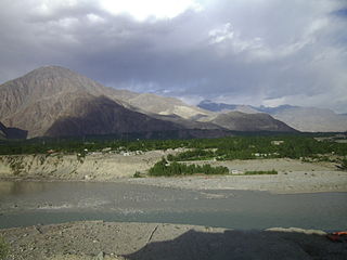
Baltistan also known as Baltiyul or Little Tibet, is a mountainous region in the Pakistani-administered territory of Gilgit-Baltistan and constitutes an northern portion of the larger Kashmir region that has been the subject of a dispute between India and Pakistan since 1947. It is located near the Karakoram and borders Gilgit to the west, China's Xinjiang to the north, Indian-administered Ladakh to the southeast, and the Indian-administered Kashmir Valley to the southwest. The average altitude of the region is over 3,350 metres (10,990 ft). Baltistan is largely administered under the Baltistan Division.

<span class="mw-page-title-main">Skardu</span> City in Gilgit-Baltistan, Pakistan

Skardu is a city located in Pakistan-administered Gilgit-Baltistan in the disputed Kashmir region. Skardu serves as the capital of Skardu District and the Baltistan Division. It is situated at an average elevation of nearly 2,500 metres above sea level in the Skardu Valley, at the confluence of the Indus and Shigar rivers. The city is an important gateway to the eight-thousanders of the nearby Karakoram mountain range. The Indus River running through the region separates the Karakoram from the Ladakh Range.

<span class="mw-page-title-main">Trans-Karakoram Tract</span> Chinese-administered area in the northern half of Kashmir near the Shaksgam River

The Trans-Karakoram Tract, also known as the Shaksgam Tract, is an area of approximately 5,200 km2 (2,000 sq mi) north of the Karakoram watershed, including the Shaksgam valley. The tract is administered by China as part of its Taxkorgan and Yecheng counties in the Xinjiang Uyghur Autonomous Region. Although the Shaksgam tract was originally under the control of India following the accession of Jammu and Kashmir to India in 1947, Pakistan took control of the region after the First India-Pakistan War and subsequently ceded it to China in 1963 through the Sino-Pakistan Agreement, and a border based on actual ground positions was recognized as the international border by China and Pakistan. The Shaksgam Tract, along with the entire Kashmir region, is claimed by India. Further, New Delhi has never accepted the China-Pakistan boundary pact, asserting that Islamabad "unlawfully" attempted to cede the area to Beijing.

<span class="mw-page-title-main">Leh district</span> District of Ladakh, administered by India

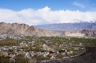
Leh district is a district in Indian-administered Ladakh in the disputed Kashmir-region. Ladakh is an Indian-administered union territory. With an area of 45,110 km2, it is the second largest district in the country, second only to Kutch. It is bounded on the north by Gilgit-Baltistan's Kharmang and Ghanche districts and Xinjiang's Kashgar Prefecture and Hotan Prefecture, to which it connects via the historic Karakoram Pass. Aksai Chin and Tibet are to the east, Kargil district to the west, and Lahul and Spiti to the south. The district headquarters is in Leh. It lies between 32 and 36 degree north latitude and 75 to 80 degree east longitude.

<span class="mw-page-title-main">Chilas</span> City administered by Pakistan in Gilgit-Baltistan

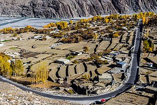
Chilas is a city in Pakistani-administered Gilgit–Baltistan in the disputed Kashmir region. It is the divisional capital of Diamer Division and is located on the Indus River. It is part of the Silk Road, connected by the Karakoram Highway and N-90 National Highway to Islamabad and Peshawar in the southwest, via Hazara and Malakand divisions of Khyber Pakhtunkhwa. To the north, Chilas connects to the cities of Tashkurgan and Kashgar in Xinjiang, China, via Gilgit, Aliabad, Sust, and the Khunjerab Pass.

<span class="mw-page-title-main">Ghanche District</span> District of Gilgit-Baltistan administered by Pakistan in Gilgit-Baltistan

Ghanche District is a district of Pakistan-administered Gilgit-Baltistan in the disputed Kashmir region. It is the eastern-most district of Gilgit-Baltistan. It is the coldest place within Pakistan as it is situated on the "third pole", with temperatures reaching below -20 °C in the winter. The Khaplu Valley and the Hushe Valley form the gateway for the great Baltoro Muztagh, the subrange of the Karakoram Mountains that includes the mighty peaks of K2, Broad Peak, the Gasherbrums and Masherbrum ,all of which are also included in the Skardu District).

<span class="mw-page-title-main">Skardu District</span> District of Gilgit-Baltistan administered by Pakistan

The Skardu District is a district of Pakistan-administered Gilgit-Baltistan in the disputed Kashmir region. Skardu District is bounded on the east by the Ghanche District, on the south by the Kharmang District, on the west by the Astore District, on the north-west by the Rondu District and on the north by the Shigar district. The district headquarters is the town of Skardu, which is also the division headquarters.

<span class="mw-page-title-main">Gilgit District</span> District of Gilgit-Baltistan in Pakistan

The Gilgit District is one of the 14 districts of Pakistan-administered territory of Gilgit-Baltistan in the disputed Kashmir region. The headquarters of the district is the town of Gilgit. At the 1998 census, the Gilgit District had a population of 243,324. The district includes Gilgit, the Bagrot Valley, Juglot, Danyore, Sultanabad, Naltar Peak, and the Nomal Valley. The highest peak in the district is Distaghil Sar 7,885 metres (25,869 ft), which is the seventh-highest peak in Pakistan and 19th highest in the world.

<span class="mw-page-title-main">Astore District</span> Administrative unit of Gilgit-Baltistan, Pakistan

Astore District is a district of Pakistan-administered Gilgit-Baltistan in the disputed Kashmir region. It is one of the 14 districts of the Pakistani-administered territory of Gilgit−Baltistan. Its administrative headquarters are located at Eidgah in the Astore Valley. Astore District is bounded by Gilgit District to the north, Roundu District to the northeast, Skardu District to the east, Kharmang District to the southeast, Diamer District to the west, the Neelum District of Azad Jammu and Kashmir to the southwest, and the Bandipore District of Indian-administered disputed Kashmir region to the south.

<span class="mw-page-title-main">Gilgit-Baltistan</span> Region administered by Pakistan

Gilgit-Baltistan, formerly known as the Northern Areas, is a region administered by Pakistan as an administrative territory and consists of the northern portion of the larger Kashmir region, which has been the subject of a dispute between India and Pakistan since 1947 and between India and China since 1959. It borders Azad Kashmir to the south, the province of Khyber Pakhtunkhwa to the west, the Wakhan Corridor of Afghanistan to the north, the Xinjiang region of China to the east and northeast, and the Indian-administered union territories of Jammu and Kashmir and Ladakh to the southeast.

Gilgit-Baltistan is an administrative territory of Pakistan that borders the province of Khyber Pakhtunkhwa to the west, Azad Kashmir to the southwest, Wakhan Corridor of Afghanistan to the northwest, the Xinjiang Uyghur Autonomous Region of China to the north, and the Indian-administered region of Jammu and Kashmir to the south and south-east.

<span class="mw-page-title-main">Shigar District</span> District of Gilgit-Baltistan administered by Pakistan

Shigar District is a district in Gilgit-Baltistan area of Pakistan in the disputed Kashmir region. It is home to the world's second highest peak, K2, also known as Chhogori and Mount Godwin-Austen. The district is bounded on the north by the Nagar District, the Hunza District, and the Kashgar Prefecture of China's Xinjiang Uyghur Autonomous Region, on the south-east by the Ghanche District, on the south-west by the Rondu and Skardu districts, and on the west by the Gilgit District. Shigar District was established in 2015, prior to which it had been part of the Skardu District.

<span class="mw-page-title-main">China–Pakistan border</span> International border

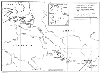
The China–Pakistan border is 596 kilometres (370 mi) and runs west–east from the tripoint with Afghanistan to the disputed tripoint with India in the vicinity of the Siachen Glacier. It traverses the Karakoram Mountains, one of the world's tallest mountain ranges. Hunza District,. Nagar District,Shigar District and Ghanche District in Gilgit-Baltistan administered by Pakistan, border Taxkorgan Tajik Autonomous County and Kargilik/Yecheng County in Kashgar Prefecture, Xinjiang Uygur Autonomous Region, China.

<span class="mw-page-title-main">Hunza District</span> District of Gilgit-Baltistan administered by Pakistan

Hunza District is a district of Pakistan-administered Gilgit-Baltistan in the disputed Kashmir region. It is one of the 14 districts of the Gilgit-Baltistan region. It was established in 2015 by the division of the Hunza–Nagar District in accordance with a government decision to establish more administrative units in Gilgit-Baltistan. The district headquarters is the town of Karimabad.

References

  1. "Mount Everest | Height, Location, Map, Facts, Climbers, & Deaths". Encyclopedia Britannica. Retrieved 2021-03-11.
  2. "K2". Encyclopedia Britannica. 18 November 2019. Retrieved 27 February 2021. Quote: "K2 is located in the Karakoram Range and lies partly in a Chinese-administered enclave of the Kashmir region within the Uygur Autonomous Region of Xinjiang, China, and partly in the Gilgit-Baltistan portion of Kashmir under the administration of Pakistan."
  3. "K2 | Geography & history". Encyclopedia Britannica. Retrieved 2021-03-11.
  4. "Kanchenjunga | mountain, Asia". Encyclopedia Britannica. Retrieved 2021-03-11.
  5. "Nanga Parbat | mountain, Jammu and Kashmir INDIA". Encyclopedia Britannica. Retrieved 2021-03-05.
  6. Wholly claimed by China as a part of its Tibet Autonomous Region; Actually Bhutan   China
  7. Strictly not in the Himalaya, but in the Nyenchen Tanglha Shan in East Tibet
  8. "Gyala Peri - Peakbagger.com". www.peakbagger.com. Retrieved 2021-03-05.
  9. Wholly claimed by Bhutan, but on the border of the Tibet Autonomous Region according to China.
  10. "Noijin Kangsang". PeakVisor. Retrieved 2021-03-05.
  11. Strictly not in the Himalaya, but in the Transhimalaya on the Tibetan plateau
  12. Godin, L.; et al. (1999). Allison MacFarlane; Rasoul B. Sorkhabi; Jay Quade (eds.). "High strain zone in the hanging wall of the Annapurna detachment". Himalaya and Tibet: Mountain Roots to Mountain Tops (328). GSA: 201.
  13. Kumar, Mayank (September 26, 2019). "Not Khardung La, This Is the World's Highest Motorable Pass. Yes, It's in India!".