Ecology of the Himalayas

Last updated

The ecology of the Himalayas varies with climate, rainfall, altitude, and soils. The climate ranges from tropical at the base of the mountains to permanent ice and snow at the highest elevations. The amount of yearly rainfall increases from west to east along the southern front of the range. This diversity of climate, altitude, rainfall and soil conditions supports a variety of distinct plant and animal species, such as the Nepal gray langur (Semnopithecus schistaceus) [1]

Contents

Lowland forests

On the Indo-Gangetic plain at the base of the mountains, an alluvial plain drained by the Indus and Ganges-Brahmaputra river systems, vegetation varies from west to east with rainfall. The xeric Northwestern thorn scrub forests occupy the plains of Pakistani and the Indian Punjab. [2] Further east lie the Upper Gangetic Plains moist deciduous forests of Uttarakhand and Uttar Pradesh [3] and the Lower Gangetic Plains moist deciduous forests of Bihar and West Bengal. [4] These are monsoon forests, with drought-deciduous trees that lose their leaves during the dry season. The moister Brahmaputra Valley semi-evergreen forests occupy the plains of Assam. [5]

The Terai belt

Indian rhinoceros in the Terai Rhinoceros unicornis chitwan national park nepal 2005 2.jpg
Indian rhinoceros in the Terai

Above the alluvial plain lies the Terai strip, a seasonally marshy zone of sand and clay soils. The Terai has higher rainfall than the plains, and the downward-rushing rivers of the Himalaya slow down and spread out in the flatter Terai zone, depositing fertile silt during the monsoon season and receding in the dry season. The Terai has a high water table due to groundwater percolating down from the adjacent zone. [6] The central part of the Terai belt is occupied by the Terai-Duar savanna and grasslands, a mosaic of grasslands, savannas, deciduous and evergreen forests that includes some of the world's tallest grasslands. [7] The grasslands of the Terai belt are home to the Indian rhinoceros (Rhinoceros unicornis).

Bhabhar belt

Above the Terai belt is an upland zone known as the Bhabhar, a zone of porous and rocky soils made up of debris washed down from the higher ranges. The belt lies at the foot of the Himalayas where the Himalayan streams descend on to the plains. [6] The Bhabhar and the lower Shiwalik ranges have a subtropical climate. The Himalayan subtropical pine forests occupy the western end of the subtropical belt, with forests dominated by Chir Pine (Pinus roxburghii). [8] The central part of the range is home to the Himalayan subtropical broadleaf forests, an ecoregion that has many different kinds of forest. One kind of forest is dominated by the sal tree (Shorea robusta). [9]

Siwalik Hills

Also called Churia or Margalla Hills, Sivalik Hills is an intermittent outermost range of foothills extending across the Himalayan region through Pakistan, India, Nepal and Bhutan. This region consists of many sub-ranges. Summits are generally 1,500 to 2,000 meters (4,900 to 6,600 ft). [10] Steeper southern slopes form along a fault zone called Himalayan Frontal Thrust (HFT); [11] northern slopes are gentler. Permeable conglomerates and other rocks allow rainwater to percolate downslope into the Bhabhar and Terai, supporting only scrubby forests upslope. The Himalayan subtropical broadleaf forests continue here. [9]

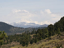
Inner Terai or Dun Valleys

The Inner Terai valleys are open valleys north of Shiwalik Hills or nestled between Shiwalik subranges. Examples include Dehra Dun in India and Chitwan in Nepal. Himalayan subtropical broadleaf forests grow here.

Lesser Himalaya

Himalayas from Kullu Valley, Himachal Pradesh. Himalayas from Kullu Valley, Himachal Pradesh.jpg
Himalayas from Kullu Valley, Himachal Pradesh.

Also called the Mahabharat Range, the Lesser Himalayas is a prominent range 2,000 to 3,000 meters (6,600 to 9,800 ft) high formed along the Main Boundary Thrust fault zone, with a steep southern face and gentler northern slopes. The range is nearly continuous except for river gorges, where groups of rivers from the north gather like candelabra in a handful of places to break through the range.

At these elevations and above, the biogeography of the Himalayas is generally divided by the Kali Gandaki Gorge in central Nepal, one of the deepest canyons in the world.

At the middle elevations of the range, the subtropical forests yield to a belt of temperate broadleaf and mixed forests growing between 1,500 and 3,000 meters (4,900 and 9,800 ft), with the western Himalayan broadleaf forests to the west of the Gandaki River, and the eastern Himalayan broadleaf forests to the east. The western broadleaf forests stretch from the Kashmir Valley, across Himachal Pradesh and Uttarakhand, and through western Nepal. The eastern broadleaf forests stretch across eastern Nepal, through Sikkim and Bhutan, and through much of Arunachal Pradesh.

Midlands

This 'hilly' region (Pahad), averaging about 1,000 meters (3,300 ft) immediately north of the Mahabharat Range, rises to about 4,000 meters (13,000 ft) over a distance of 100 kilometres (62 mi) at the Main Central Thrust fault zone, where the Greater Himalaya begin.

Subalpine forest at Cher-tang La, Bhutan GangkharPuensum3.jpg
Subalpine forest at Cher-tang La, Bhutan

Above the broadleaf forests, between 3,000 and 4,000 meters (9,800 and 13,100 ft), are temperate coniferous forests, likewise split by the Gandaki River. The western Himalayan subalpine conifer forests are found below treeline in northern Pakistan, Jammu and Kashmir, Himachal Pradesh, Uttarakhand, and western Nepal. The eastern Himalayan subalpine conifer forests are found in eastern Nepal, Sikkim, Bhutan, and Arunachal Pradesh. Along the border between Arunachal Pradesh and Tibet, the eastern subalpine conifer forests mix with the northeastern Himalayan subalpine conifer forests. East Himalayan Fir, West Himalayan Spruce, and Himalayan Hemlock are some important trees of these forests. Rhododendrons are exceptionally diverse here, with over 60 species recorded in the northeastern Himalayan subalpine conifer forests.

Greater Himalaya

North of the Main Central Thrust, the highest ranges rise abruptly as much as 4,000 meters (13,000 ft) into the realm of perpetual snow and ice. As the Himalayan system becomes wider from east to west, the number of parallel high ranges increases. For example, the Kagmara and Kanjiroba ranges both reach well over 6,000 meters (20,000 ft) north of the Dhaulagiri Himalaya in central Nepal.

Valley of the Flowers "Flowers Blossom at Valley of Flowers Chamoli, India.jpg" 08.jpg
Valley of the Flowers

Alpine tundra lies above treeline. The areas above natural treeline is chiefly composed of annuals, which is differentiated into alpine grasslands and meadows. The steep slopes are mainly predominated by grasses whereas the meadows are dominated by herbaceous species. [12] The northwestern Himalayan alpine shrub and meadows are found in the high elevations of northern Pakistan, Jammu and Kashmir, and Himachal Pradesh. To the east, the western Himalayan alpine shrub and meadows cover extensive areas along the Tibetan border with Uttarakhand and western Nepal. The eastern Himalayan alpine shrub and meadows grow above the eastern and northeastern subalpine conifer forests, along the Tibetan border with eastern Nepal, Sikkim, Bhutan, and Arunachal Pradesh. The shrublands are composed of junipers as well as a wide variety of rhododendrons. They also possess a remarkable variety of wildflowers: Valley of Flowers National Park in the western Himalayan alpine shrub and meadows contains over 520 species of plants, of these 498 are flowering plants. [13] The upper limit of the grasslands increases from west to east, rising from 3,500 meters (11,500 ft) to 5,500 meters (18,000 ft). The grasslands are the summer habitat of the endangered snow leopard (Panthera uncia).

Trans-Himalaya

The watershed between rivers flowing south into the Ganges or Indus and rivers flowing north into the Brahmaputra or mainstem Indus that flow around the ends of the entire range often follows somewhat lower, less rugged mountains tens of kilometers north of the highest ranges. South-flowing rivers form valleys in this region, often semi-arid due to rainshadow effects. These valleys hold some of the highest permanent villages on earth on the slopes.

Related Research Articles

<span class="mw-page-title-main">Geography of Nepal</span>

Nepal measures about 880 kilometers (547 mi) along its Himalayan axis by 150 to 250 kilometers across. It has an area of 147,516 km2 (56,956 sq mi).

<span class="mw-page-title-main">Terai–Duar savanna and grasslands</span>

The Terai–Duar savanna and grasslands is a narrow lowland ecoregion at the base of the Himalayas, about 25 km (16 mi) wide, and a continuation of the Indo-Gangetic Plain in India, Nepal and Bhutan. It is colloquially called Terai in the Ganges Basin east to Nepal, then Dooars in West Bengal, Bhutan and Assam east to the Brahmaputra River. It harbours the world's tallest grasslands, which are the most threatened and rare worldwide.

<span class="mw-page-title-main">Upper Gangetic Plains moist deciduous forests</span> Ecoregion in northern India

The Upper Gangetic Plains moist deciduous forests is a tropical and subtropical moist broadleaf forests ecoregion of northern India.

<span class="mw-page-title-main">Lower Gangetic Plains moist deciduous forests</span> Ecoregion of India and Bangladesh

The Lower Gangetic Plains moist deciduous forests is a tropical and subtropical moist broadleaf forests ecoregion of Bangladesh and India. The ecoregion covers an area of 254,100 square kilometres (98,100 sq mi), comprising most of Bangladesh and the Indian states of West Bengal, Bihar and Tripura, and extending into adjacent states of Odisha, Uttar Pradesh and a tiny part of Assam, as well as adjacent western Myanmar.

<span class="mw-page-title-main">Himalayan subtropical broadleaf forests</span>

The Himalayan subtropical broadleaf forests is an ecoregion that extends from the middle hills of central Nepal through Darjeeling into Bhutan and also into the Indian States of Uttar Pradesh and Bihar. It represents the east–west-directed band of subtropical broadleaf forest at an altitude of between 500 and 1,000 m along the Outer Himalayan Range, and includes several forest types traversing an east to west moisture gradient.

<span class="mw-page-title-main">Eastern Himalayan broadleaf forests</span>

The Eastern Himalayan broadleaf forests is a temperate broadleaf forest ecoregion found in the middle elevations of the eastern Himalayas, including parts of Nepal, India, Bhutan, Myanmar and China. These forests have an outstanding richness of wildlife.

<span class="mw-page-title-main">Western Himalayan alpine shrub and meadows</span>

The Western Himalayan alpine shrub and meadows is a montane grasslands and shrublands ecoregion of Nepal, India, and Tibet, which lies between the tree line and snow line in the western portion of the Himalaya Range.

<span class="mw-page-title-main">Eastern Himalayan alpine shrub and meadows</span> Ecoregion in the Eastern Himalayas

The Eastern Himalayan alpine shrub and meadows is a montane grasslands and shrublands ecoregion of Bhutan, China, India, Myanmar, and Nepal, which lies between the tree line and snow line in the eastern portion of the Himalaya Range.

<span class="mw-page-title-main">Northern Triangle temperate forests</span>

The Northern Triangle temperate forests is a temperate broadleaf and mixed forest ecoregion of thick forest covering the mountains of northern Myanmar.

<span class="mw-page-title-main">Geography of Uttarakhand</span>

Uttarakhand has a total geographic area of 53,483 km2, of which 86% is mountainous and 65% is covered by forest. Most of the northern parts of the state are part of Greater Himalaya ranges, covered by the high Himalayan peaks and glaciers, while the lower foothills were densely forested till denuded by the British log merchants and later, after independence, by forest contractors. Recent efforts in reforestation, however, have been successful in restoring the situation to some extent. The unique Himalayan ecosystem plays host to many animals, plants and rare herbs. Two of India's great rivers, the Ganges and the Yamuna take birth in the glaciers of Uttarakhand, and are fed by myriad lakes, glacial melts and streams.

<span class="mw-page-title-main">Western Himalayan broadleaf forests</span> Temperate mixed forest ecoregion in western Himalaya

The Western Himalayan broadleaf forests is a temperate broadleaf and mixed forest ecoregion which is found in the middle elevations of the western Himalayas, including parts of Nepal, India, and Pakistan.

<span class="mw-page-title-main">Northeastern Himalayan subalpine conifer forests</span> Ecoregion in Northeast Himalayas

The Northeastern Himalayan subalpine conifer forests are a temperate coniferous forests ecoregion of the middle to upper elevations of the eastern Himalayas and southeast Tibetan Plateau. The ecoregion occurs in southeastern Tibet Autonomous Region, China, in northern and eastern Arunachal Pradesh, India, and extreme eastern Bhutan.

Pangolakha Wildlife Sanctuary is a wildlife reserve in the Pakyong District of the state of Sikkim in India. It is about 28 kilometres (17 mi) east of Rorathang and about 40 kilometres (25 mi) by road from Rangpo city. The total notified area of the park is around 124 square kilometres (48 sq mi) while inside the wildlife sanctuary there are a few hamlets: Aritar, Dakline Lingtam, Phadamchen, Dzuluk, Gnathang Monastery Kupup. This wildlife sanctuary is linked to the forests of Neora Valley National Park of West Bengal as well as forests of Samtse, Bhutan and Haa district Bhutan. The area that comes under this biosphere has been declared in 1999 as a wildlife sanctuary under biogeographic province category 2C.

<span class="mw-page-title-main">Fambong Lho Wildlife Sanctuary</span>

Fambong Lho Wildlife Sanctuary is a 51 km2 (20 sq mi) large wildlife sanctuary in Gangtok district of the state of Sikkim in India. It is contiguous with Khangchendzonga National Park and located around 30 km (19 mi) west of Gangtok. It hosts a few small hamlets inside, namely Dikchu, Pangthang, and Mangan and is managed by State Forest Department.

<span class="mw-page-title-main">Geography of Arunachal Pradesh</span>

Arunachal Pradesh is primarily a hilly tract nestled in the foothills of the Himalayas in northeast India. It is spread over an area of 83,743 km2 (32,333 sq mi). 98% of the geographical area is land out of which 80% is forest cover; 2% is water. River systems in the region, including those from the higher Himalayas and Patkoi and Arakan Ranges, eventually drain into the Brahmaputra River.

<span class="mw-page-title-main">Outline of Uttarakhand</span> Overview of and topical guide to Uttarakhand

The following outline is provided as an overview of and topical guide to Uttarakhand:

References

  1. Kumar, A.; Yongzu, Z. & Molur, S. (2008). "Semnopithecus schistaceus". The IUCN Red List of Threatened Species . IUCN. 2008: e.T39840A10275563. doi: 10.2305/IUCN.UK.2008.RLTS.T39840A10275563.en . Retrieved 22 June 2019.
  2. "Northwestern thorn scrub forests". Terrestrial Ecoregions. World Wildlife Fund.
  3. "Upper Gangetic Plains moist deciduous forests". Terrestrial Ecoregions. World Wildlife Fund.
  4. "Lower Gangetic plains moist deciduous forests". Terrestrial Ecoregions. World Wildlife Fund.
  5. "Brahmaputra Valley semi-evergreen forests". Terrestrial Ecoregions. World Wildlife Fund.
  6. 1 2 Mani, M.S. (2012). Ecology and Biogeography in India. Springer Science & Business Media. p. 690.
  7. Dinerstein, E., Loucks, C. (2001). "Terai-Duar savanna and grasslands". Terrestrial Ecoregions. World Wildlife Fund.
  8. "Himalayan subtropical pine forests". Terrestrial Ecoregions. World Wildlife Fund.
  9. 1 2 "Himalayan Subtropical Broadleaf Forests". Terrestrial Ecoregions. World Wildlife Fund.
  10. Kohli, M.S. (2002). Mountains of India: Tourism, Adventure and Pilgrimage. Indus Publishing. p. 24.
  11. "Geology and Major Structures of the Himalayas". GEOS 427/527 Orogenic Systems. University of Arizona. Archived from the original on 2016-11-23. Retrieved 2017-01-28.
  12. Kala, Chandra Prakash (1998). Ecology and Conservation of Alpine Meadows in the Valley of Flowers National Park, Garhwal Himalaya. Dehradun: Forest Research Institute. p. 180.
  13. Kala, C.P. (2004). The Valley of Flowers: Myth and Reality. Dehradun: International Book Distributor.