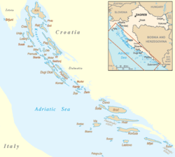
List of islands in the Adriatic

Last updated

The majority of the Adriatic sea islands are located in the northeastern Adriatic, near the Croatian coast. Croatian islands map.png
The majority of the Adriatic sea islands are located in the northeastern Adriatic, near the Croatian coast.

There are more than 1200 islands in the Adriatic Sea, 69 of which are inhabited. A recent study by the Institute of Oceanography in Split (2000) shows that there are 1246 islands: 79 large islands, 525 islets, and 642 ridges and rocks. The Italian Scuola di Geografia of Genoa states that the number is greater if one includes the small islands in the Italian lagoons of Venice and Grado, and the so-called "islands of the Po delta".

Contents

Croatia

Adriatic islands in Croatia include: [1]

Northern seacoast:

Northern Dalmatia:

Central and southern Dalmatia:

Montenegro

Gjerana Rock, Small Rock, Big Rock (Ulcinj Riviera)

In Bay of Kotor

Italy

The following islands of Italy are in the Adriatic Sea: [2]

Venetian Lagoon

The Venetian Lagoon Islands Venedig-lagune.png
The Venetian Lagoon Islands

The most important of the 130 islands in the Venetian Lagoon are:

Other inhabited islands in the Venetian Lagoon include:

Grado-Marono Lagoon

Grado Lagoon satellite image Gradolagoon.jpg
Grado Lagoon satellite image

The most important of the nearly 120 islands in the Grado-Marano Lagoon are:

Albania

Related Research Articles

<span class="mw-page-title-main">Geography of Italy</span>

The geography of Italy includes the description of all the physical geographical elements of Italy. Italy, whose territory largely coincides with the homonymous geographical region, is located in southern Europe and comprises the long, boot-shaped Italian Peninsula crossed by the Apennines, the southern side of Alps, the large plain of the Po Valley and some islands including Sicily and Sardinia. Italy is part of the Northern Hemisphere. Two of the Pelagie Islands are located on the African continent.

<span class="mw-page-title-main">Geography of Malta</span>

The geography of Malta is dominated by water. Malta is an archipelago of coralline limestone, located in Europe, in the Mediterranean Sea, 81 kilometres south of Sicily, Italy, and nearly 300 km north (Libya) and northeast (Tunisia) of Africa. Although Malta is situated in Southern Europe, it is located farther south than Tunis, capital of Tunisia, Algiers, capital of Algeria, Tangier in Morocco and also Aleppo in Syria, and Mosul in Iraq in the Middle East. Only the three largest islands – Malta, Gozo and Comino – are inhabited. Other (uninhabited) islands are: Cominotto, Filfla and the St.Paul's Islands. The country is approximately 316 km2 (122 sq mi) in area. Numerous bays along the indented coastline of the islands provide harbours. The landscape of the islands is characterised by high hills with terraced fields. The highest point, at 253 metres, Ta' Zuta on mainland Malta. The capital is Valletta.

<span class="mw-page-title-main">Venetian Lagoon</span> Enclosed bay in which the city of Venice is situated

The Venetian Lagoon is an enclosed bay of the Adriatic Sea, in northern Italy, in which the city of Venice is situated. Its name in the Italian and Venetian languages, Laguna Veneta—cognate of Latin lacus, "lake"—has provided the English name for an enclosed, shallow embayment of salt water, a lagoon.

<span class="mw-page-title-main">Santiago de Cuba Province</span> Province of Cuba

Santiago de Cuba Province is the second most populated province in the island of Cuba. The largest city Santiago de Cuba is the main administrative center. Other large cities include Palma Soriano, Contramaestre, San Luis and Songo-La Maya.

<span class="mw-page-title-main">Kornati</span> Historic site in Šibenik-Knin County, Croatia

The Kornati archipelago of Croatia, also known as the Stomorski islands, is located in the northern part of Dalmatia, south from Zadar and west from Šibenik, in the Šibenik-Knin County. With 35 kilometres length and 89 islands, some large, some small, in a sea area of about 320 square kilometres (124 sq mi), the Kornati are the densest archipelago in the Mediterranean Sea. From northwest to southeast, and from northeast to southwest they stretch for 13 km. The name of the archipelago is the plural form of the name of the largest island, called Kornat.

<span class="mw-page-title-main">Dugi Otok</span> Long island in the Adriatic sea, part of Croatia

Dugi Otok is part of Croatia and the seventh largest island in the Adriatic Sea. It is located off the Dalmatian coast, west of Zadar. It is the largest and westernmost of the Zadarian Islands, and derives its name from its distinctive shape: it is 44.5 km long by 4.8 km wide, with an area of 114 square kilometres (44 sq mi). Its elevation reaches 300 m; and many of its higher portions contain stands of Maritime Pine.

<span class="mw-page-title-main">Crveni Otok</span> Island in Croatia

Crveni Otok is a twinned island in the Croatian part of the Adriatic Sea. It is situated near Rovinj and connects the island of Sveti Andrija with neighbouring islet of Maškin with an embankment. Its area is 0.233 km2 (0.090 sq mi).

<span class="mw-page-title-main">Puttalam Lagoon</span>

The Puttalam Lagoon is a large 327 km2 (126 sq mi) lagoon in the Puttalam District, western Sri Lanka.

<span class="mw-page-title-main">Kornat</span> Island of Croatia

Kornat is an island in the Croatian part of the Adriatic Sea, in central Dalmatia. With an area of 32.44 km2 it is the 16th largest island in Croatia and the largest island in the eponymous Kornati islands archipelago. It is part of the Kornati National Park, which is composed of a total of 89 islands, islets and rocks.

<span class="mw-page-title-main">Katina (island)</span> Island in Croatia

Katina is a Croatian island in the Adriatic Sea located between Dugi Otok to the north and Kornat to the south. Its area is 1.17 km2 (0.45 sq mi).

<span class="mw-page-title-main">Kurba Vela</span> Island in Croatia

Kurba Vela is an uninhabited Croatian island in the Adriatic Sea located southeast of Kornat. Its area is 1.74 km2 (0.67 sq mi).

<span class="mw-page-title-main">Marano Lagoon</span>

Marano Lagoon is a huge lagoon in northeastern Italy. It has a surface area of around 160 square kilometres.

References

  1. "Croatia Islands". GeoNames . Retrieved October 20, 2021.
  2. "Islands of Italy". GeoNames. Retrieved October 20, 2021.