
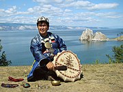
Lake Baikal is a rift lake in Russia. It is situated in southern Siberia, between the federal subjects of Irkutsk Oblast to the northwest and the Republic of Buryatia to the southeast. At 31,722 km2 (12,248 sq mi)—slightly larger than Belgium—Lake Baikal is the world's seventh-largest lake by surface area. However, because it is also the deepest lake, with a maximum depth of 1,642 metres, Lake Baikal is the world's largest freshwater lake by volume, containing 23,615.39 km3 (5,670 cu mi) of water or 22–23% of the world's fresh surface water, more than all of the North American Great Lakes combined. It is also the world's oldest lake at 25–30 million years, and among the clearest.

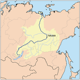
The Angara is a major river in Siberia, which traces a course through Russia's Irkutsk Oblast and Krasnoyarsk Krai. It drains out of Lake Baikal and is the headwater tributary of the Yenisey. It is 1,849 kilometres (1,149 mi) long, and has a drainage basin of 1,039,000 square kilometres (401,000 sq mi). It was formerly known as the Lower or Nizhnyaya Angara. Below its junction with the Ilim, it was formerly known as the Upper Tunguska and, with the names reversed, as the Lower Tunguska.

Irkutsk is the largest city and administrative center of Irkutsk Oblast, Russia. With a population of 617,473 as of the 2010 Census, Irkutsk is the 25th-largest city in Russia by population, the fifth-largest in the Siberian Federal District, and one of the largest cities in Siberia.

Irkutsk Oblast is a federal subject of Russia, located in southeastern Siberia in the basins of the Angara, Lena, and Nizhnyaya Tunguska Rivers. The administrative center is the city of Irkutsk. It borders the Republic of Buryatia and the Tuva Republic in the south and southwest, which separate it from Khövsgöl Province in Mongolia; Krasnoyarsk Krai in the west; the Sakha Republic in the northeast; and Zabaykalsky Krai in the east. It had a population of 2,370,102 at the 2021 Census.

The early history of Siberia was greatly influenced by the sophisticated nomadic civilizations of the Scythians (Pazyryk) on the west of the Ural Mountains and Xiongnu (Noin-Ula) on the east of the Urals, both flourishing before the common era. The steppes of Siberia were occupied by a succession of nomadic peoples, including the Khitan people, various Turkic peoples, and the Mongol Empire. In the Late Middle Ages, Tibetan Buddhism spread into the areas south of Lake Baikal.
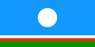
Yakuts or Sakha are a Turkic ethnic group who mainly live in the Republic of Sakha in the Russian Federation, with some extending to the Amur, Magadan, Sakhalin regions, and the Taymyr and Evenk Districts of the Krasnoyarsk region. The Yakut language belongs to the Siberian branch of the Turkic languages.
The Russian conquest of Siberia took place during 1580–1778, when the Khanate of Sibir became a loose political structure of vassalages that were being undermined by the activities of Russian explorers. Although outnumbered, the Russians pressured the various family-based tribes into changing their loyalties and establishing distant forts from which they conducted raids. It is traditionally considered that Yermak Timofeyevich's campaign against the Siberian Khanate began in 1580. The annexation of Siberia and the Far East to Russia was resisted by local residents and took place against the backdrop of fierce battles between the indigenous peoples and the Russian Cossacks, who often committed atrocities against the indigenous peoples.

Pyotr Beketov was a Cossack explorer of Siberia and founder of various fortified settlements in the region, which later developed into modern cities such as Yakutsk, Chita, and Nerchinsk.

The Siberian Route, also known as the Moscow Highway and Great Highway, was a historic route that connected European Russia to Siberia and China.

The Transbaikal Oblast was a province (oblast) of the Russian Empire, in what is now Buryatia and Zabaykalsky Krai. The oblast was created out of the territory of the Irkutsk Governorate in 1851, and was dissolved in 1917, it was briefly re-established from 1920 to 1922 before it was succeeded by the Transbaikal Governorate.
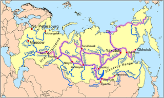
Siberian River Routes were the main ways of communication in Russian Siberia before the 1730s, when roads began to be built. The rivers were also of primary importance in the process of Russian conquest and exploration of vast Siberian territories eastwards. Since the three great Siberian rivers, the Ob, the Yenisey, and the Lena all flow into the Arctic Ocean, the aim was to find parts or branches of these rivers that flow approximately east-west and find short portages between them. Since Siberia is relatively flat, portages were usually short. Despite resistance from the Siberian tribes, Russian Cossacks were able to expand from the Urals to the Pacific in only 57 years (1582-1639). These river routes were crucial in the first years of the Siberian fur trade as the furs were easier to transport over water than land. The rivers connected the major fur gathering centers and provided for relatively quick transport between them.

Demid Sofonovich Pyanda or, according to some sources, Panteley Demidovich Pyanda, also spelled Penda (Пенда) was among the first and most important Russian explorers of Siberia. According to few historical documents and later reconstructions based on them, Pyanda, in 1620–1623, while leading a party which was hunting for Siberian furs and buying them from the locals, became the first known Russian to ascend the Lower Tunguska River and reach the proximity of the Lena, one of the world's greatest rivers. According to later legendary accounts, collected a century after his journey, Pyanda allegedly discovered the Lena River, explored much of its length, and via the Angara River returned to the Yenisey, whence he came.
Kurbat Afanasyevich Ivanov (Russian: Курбат Афанасьевич Иванов, was a Cossack explorer of Siberia. He was the first Russian to discover Lake Baikal, and to create the first map of the Russian Far East. He also is credited with creation of the early map of Chukotka and Bering Strait, which was the first to show the yet undiscovered Wrangel Island, both Diomede Islands and Alaska.
Maksim Perfilyev (Russian: Максим Перфильев was a Cossack explorer of Eastern Siberia and the first Russian to reach Transbaikalia. He was renowned for his diplomatic skills in negotiations with Tunguses, Mongols and Chinese.
The Kurumchi culture or the "Kurumchi blacksmiths" was the earliest Iron Age archaeological culture of Baikalia as proposed by Bernhard Petri. He also speculated that they were the progenitors of the Sakha people, a claim that didn't go unchallenged by his contemporaries. Petri assumed that the Kurumchi left Baikalia for the Middle Lena due to pressure from the ancestors of the Buryats.
The Kurykans were a Turkic Tiele tribe, that inhabited the Lake Baikal area with 6th century Early Kurykans migrated from Yenisey river.

Pribaikalsky National Park covers the southwest coast of Lake Baikal in southeastern Siberia. The coastal strip includes the lake-facing slopes of the Primorsky Range to the west, as well as offshore islands such as Olkhon Island to the east. It is about 50 km southeast of the city of Irkutsk, Irkutsk Oblast. The park is managed with three other nature reserves, and is a major component of the UNESCO World Heritage Site "Lake Baikal". The Angara River, which is the outflow of Lake Baikal west into the Yenisei River basin, runs through the park. The park has very high levels of biodiversity and endemic species.

The South Siberian Mountains are one of the largest mountain systems of the Russian Federation. The total area of the system of mountain ranges is more than 1.5 million km². The South Siberian Mountains are located in the Siberian and Far Eastern Federal Districts of Russia, as well as partly in Mongolia. The territory of the mountain system is one of the Great Russian Regions.
Mikhail Pavlovich Ovchinnikov was a Russian revolutionary, political exile, and amateur archeologist active in the Irkutsk Governorate. Ovchinnikov discovered many ancient sites around Irkutsk that were later reexamined by Irkutsk State University academia. His passion for Eastern Siberian archeology led to contemporaries dubbing him "the Father of Siberian Archeology."
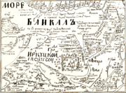 Russian map c. 1700, Baikal (not to scale) is at top.
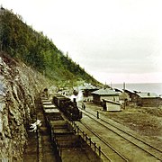 Steam locomotive on the Circum-Baikal Railroad
 The eastern coast of Lake Baikal


