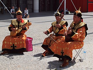
The Mongols are an East Asian ethnic group native to Mongolia, China, as well as Buryatia and Kalmykia republics of Russia. The Mongols are the principal member of the large family of Mongolic peoples. The Oirats and the Buryats are classified either as distinct ethno-linguistic groups or subgroups of Mongols.

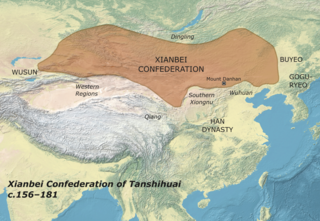
The Xianbei were an ancient nomadic people that once resided in the eastern Eurasian steppes in what is today Mongolia, Inner Mongolia, and Northeastern China. The Xianbei were strongly suggested to be a multilingual, multi-ethnic confederation consisting of mainly Proto-Mongols, and, to a minor degree, Tungusic and Turkic peoples. They originated from the Donghu people who splintered into the Wuhuan and Xianbei when they were defeated by the Xiongnu at the end of the third century BC. Following the split, the Xianbei people did not have a direct contact with the Han dynasty, residing to the north of the Wuhuan. In the first century BC, the Xianbei began to actively engage in the struggle between the Han and Xiongnu, which culminated in the Xianbei replacing the Xiongnu on the Mongolian Plateau in 93 AD.

The Monguor, the Tu people, the White Mongol or the Tsagaan Mongol, are Mongolic people and one of the 56 officially recognized ethnic groups in China. The "Tu" ethnic category was created in the 1950s.
The proto-Mongols emerged from an area that had been inhabited by humans as far back as 45,000 years ago during the Upper Paleolithic. The people there went through the Bronze and Iron Ages, forming tribal alliances, peopling, and coming into conflict with early polities in the Central Plain.

The Yuwen is a Chinese compound surname which originated from a pre-state clan of Xianbei ethnicity of Xiongnu origin during the era of Sixteen Kingdoms in China, until its destruction by Former Yan's prince Murong Huang in 345. Among the eastern Xianbei clans that ranged from the central part of the present day Liaoning province and eastward, Yuwen clan was the largest, and was awarded the position of the leader of eastern Xianbei (東部大人) by Chinese rulers. A descendant of the Yuwen tribe, Yuwen Tai, established the Northern Zhou Dynasty in the 6th century.
Yuanhe Xingzuan "The register of the great families from the Yuanhe reign (806-820)" vol. 6, the Yuwen part 2 records:
(宇文)本遼東南單于之後, 有普回因獵得玉璽, 以為天授. 鮮卑俗呼天子為宇文, 因號宇文氏.
(The Yuwen) originally were the descendants of the southern Shanyu. Someone within them called Puhui got a jade seal when he was hunting. This was regarded as a sign of imperial enthronement from heaven. According to Xianbei tradition, the son of the heaven was called the Yuwen. Thus (Puhui) called himself the Yuwen.

The Hinggan League is a prefecture-level subdivision of the Inner Mongolia Autonomous Region of the People's Republic of China. It borders Hulun Buir to the north, the Republic of Mongolia and Xilingol League to the west, Tongliao to the south and the provinces of Jilin and Heilongjiang to the east. The name is derived from the Greater Khingan mountain range that crosses the league from the northwest to the southeast.

Xing'an refers to a former province, which once occupied western Heilongjiang and part of northwest Jilin provinces of China. The name is related to that of the Greater Khingan Mountains. Another name used for this land was Barga, which is also the name used for the western part of the province, the Barga district.

Tongliao is a prefecture-level city in eastern Inner Mongolia, People's Republic of China. The area is 59,535 square kilometres (22,987 sq mi) and as of the 2020 census, its population was 2,873,168. However, the city proper made of Horqin district, had 921,808 inhabitants. The city was the administrative centre of the defunct Jirem League.
Khingan is the Mongolian name for the mountains divided into the:

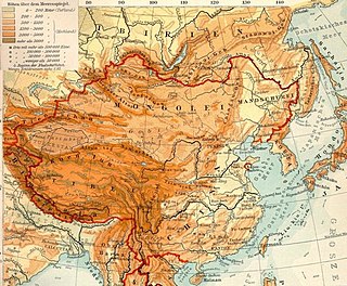
The Mongolian Plateau is an inland plateau in Asia that lies between 37°46′-53°08′N and 87°40′-122°15′E and has an area of approximately 3,200,000 square kilometers (1,200,000 sq mi). It is bounded by the Greater Hinggan Mountains in the east, the Yin Mountains to the south, the Altai Mountains to the west, and the Sayan and Khentii mountains to the north. The plateau includes the Gobi Desert as well as dry steppe regions. It has an elevation of roughly 1,000 to 1,500 meters, with the lowest point in Hulunbuir and the highest point in the Altai.
Donghu was a tribal confederation of "Hu" (胡) nomadic people that was first recorded from the 7th century BCE and was taken over by the Xiongnu in 150 BCE. They lived in northern Hebei, southeastern Inner Mongolia and the western part of Liaoning, Jilin and Heilongjiang along the Yan Mountains and Greater Khingan Range.

Heshigten or Hexigten Global Geopark is a UNESCO Global Geopark in Hexigten Banner, Chifeng city, Inner Mongolia, China. Its 1,750 km2 area is contained in eight separate areas of scenic beauty and geologic significance, including volcanic, glacial, and desert features.
Hinggan is the Manchu form of Khingan, the Mongolian name of a series of mountain ranges. It now most often refers to:

Lesser Khingan is a mountain range in China's Heilongjiang province and the adjacent parts of Russia's Amur Oblast and Jewish Autonomous Oblast.
Xing'an is the atonal pinyin romanization of various Chinese words and names. It may refer to:

The Tuoba (Chinese) or Tabgatch, also known by other names, was an influential Xianbei clan in early imperial China. During the Sixteen Kingdoms after the fall of Han and the Three Kingdoms, the Tuoba established and ruled the Dai state in northern China. The dynasty ruled from 310 to 376 and then was restored in 386. The same year, the dynasty was renamed Wei, later distinguished in Chinese historiography as the Northern Wei. This powerful state gained control of most of northern China, supporting Buddhism while increasingly sinicizing. As part of this process, in 496, the Emperor Xiaowen changed the imperial clan's surname from Tuoba to Yuan. The empire split into Eastern Wei and Western Wei in 535, with the Western Wei's rulers briefly resuming use of the Tuoba name in 554.

Nora Nature Reserve is a Russian 'zapovednik' on the northeastern part of the Amur-Zeya lowland plain between the Nora River and the Selemdzha River. The reserve is known for its herd of Norsk roe deer, the largest migrating herd in the world, with 5,000-7,000 individuals migrating through every September. The terrain is half forested, and half wetland and bogs, in the meeting zone between Siberian, Okhotsk, and Mongolian plant and animal communities. The reserve is situated in the Selemdzhinsky District of Amur Oblast.

The Da Hinggan-Dzhagdy Mountains conifer forests ecoregion covers the Greater Khingan Mountains of Northeast China, and across the border north into the Russian Far East where it follows the mountain ridge for another 500 km to the east. The mountain forests exhibit a floral community called "Daurian flora", a combination of the Siberian taiga to the north and the Manchurian floral types to the south. The eastern slopes are steep and drained by many rivers, the western slopes are gentler, and there are grasslands on some slopes. The ecoregion is in the Palearctic realm, with a subarctic climate. It covers 35,199,998 km2 (13,590,795 sq mi).
Genmou was a vassal state during the Zhou dynasty in ancient China. Genmou was founded by the Eastern Yi and was conquered by the state of Lu in the 9th year of Lu's Duke Xuan's reign.

The Dzhagdy Range is a range of mountains in far North-eastern Russia. Administratively it belongs partly to Amur Oblast and partly to the Khabarovsk Krai of the Russian Federation.


