A polar circle is a geographic term for a conditional circular line (arc) referring either to the Arctic Circle or the Antarctic Circle. These are two of the keynote circles of latitude (parallels). On Earth, the Arctic Circle is currently drifting northwards at a speed of about 14.5 m per year and is now at a mean latitude (i.e. without taking into account the astronomical nutation) of 66°33′50.1″N; the Antarctic Circle is currently drifting southwards at a speed of about 14.5 m per year and is now at a mean latitude of 66°33′50.1″S.[1] Polar circles are often equated with polar regions of Earth. Due to their inherent climate environment, the bulk of the Arctic Circle, much of which is sea, is sparsely settled whereas this applies to all of Antarctica which is mainly land and sheltered ice shelves.
If Earth had no atmosphere, then both polar circles (arcs) would see at least a day a year when the center of the Sun is continuously above the horizonand at least a day a year when it is always below the horizon – a polar day and a polar night as is the case for longer, within the circles. Up to and including the associated poles (North and South), known geographically as the frigid zones, such duration extends up to half of the year, namely, close to the poles. Instead, atmospheric refraction and the Sun's light reaching the planet as an extended object rather than a point source means that just within each circle the Earth's surface does not experience any proper polar night, 24 hours where the sun does not rise. By these same two factors, just outward of each circle still experiences a polar day (a day in which the sun does not fully set).
The latitude of the polar circles is + or −90 degrees (which refers to the North and South Pole, respectively) minus the axial tilt (that is, of the Earth's axis of daily rotation relative to the ecliptic, the plane of the Earth's orbit). This predominant, average tilt of the Earth varies slightly, a phenomenon described as nutation. Therefore, the latitudes noted above are calculated by averaging values of tilt observed over many years. The axial tilt also exhibits long-term variations as described in the reference article (a difference of 1 second of arc (″) in the tilt is equivalent to a change of about 31metres north or south in the positions of the polar circles on the Earth's surface).
Correspondence to polar night and day
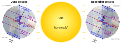
Relationship between Earth's axial tilt (ε) to the tropical and polar circles
The polar circles would almost precisely match the boundaries for the zones where the polar night and the polar day would occur throughout the winter solstice and summer solstice day respectively. They do so loosely due to two effects. The first one is atmospheric refraction, in which the Earth's atmosphere bends light rays near the horizon. The second effect is caused by the angular diameter of the Sun as seen from the Earth's orbital distance (which varies very slightly during each orbit). These factors mean the ground-observed boundaries are 80 to 100 kilometres (50 to 62mi) away from the circle.[citation needed] A further global factor for this numerical range is Earth's nutation, which is a very small change in tilt. Observers higher above sea level can see a tiny amount of the Sun's disc (see horizon) where at lower places it would not rise. For the Arctic Circle, being 80–100 km north of the circle in winter, and 80–100km south of the circle in summer; the inverse directions apply to the other circle.[2]
In astronomy, declination is one of the two angles that locate a point on the celestial sphere in the equatorial coordinate system, the other being hour angle. The declination angle is measured north (positive) or south (negative) of the celestial equator, along the hour circle passing through the point in question.
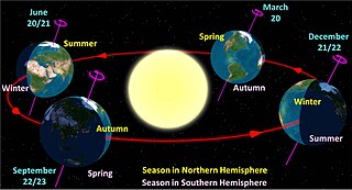
A solstice is the time when the Sun reaches its most northerly or southerly excursion relative to the celestial equator on the celestial sphere. Two solstices occur annually, around 20-22 June and 20-22 December. In many countries, the seasons of the year are defined by reference to the solstices and the equinoxes.
The Tropic of Cancer, also known as the Northern Tropic, is the Earth's northernmost circle of latitude where the Sun can be seen directly overhead. This occurs on the June solstice, when the Northern Hemisphere is tilted toward the Sun to its maximum extent. It also reaches 90 degrees below the horizon at solar midnight on the December Solstice. Using a continuously updated formula, the circle is currently 23°26′09.9″ (or 23.43607°) north of the Equator.
In astronomy, an analemma is a diagram showing the position of the Sun in the sky as seen from a fixed location on Earth at the same mean solar time, as that position varies over the course of a year. The diagram resembles a figure eight. Globes of the Earth often display an analemma as a two-dimensional figure of equation of time vs. declination of the Sun.
A circle of latitude or line of latitude on Earth is an abstract east–west small circle connecting all locations around Earth at a given latitude coordinate line.
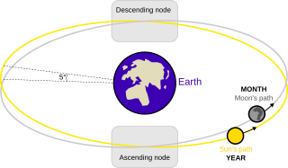
A lunar node is either of the two orbital nodes of the Moon, that is, the two points at which the orbit of the Moon intersects the ecliptic. The ascending node is where the Moon moves into the northern ecliptic hemisphere, while the descending node is where the Moon enters the southern ecliptic hemisphere.
Midnight sun, also known as polar day, is a natural phenomenon that occurs in the summer months in places north of the Arctic Circle or south of the Antarctic Circle, when the Sun remains visible at the local midnight. When midnight sun is seen in the Arctic, the Sun appears to move from left to right. In Antarctica, the equivalent apparent motion is from right to left. This occurs at latitudes ranging from approximately 65°44' to exactly 90° north or south, and does not stop exactly at the Arctic Circle or the Antarctic Circle, due to refraction.
The polar regions, also called the frigid zones or polar zones, of Earth are Earth's polar ice caps, the regions of the planet that surround its geographical poles, lying within the polar circles. These high latitudes are dominated by floating sea ice covering much of the Arctic Ocean in the north, and by the Antarctic ice sheet on the continent of Antarctica and the Southern Ocean in the south.
Earth orbits the Sun at an average distance of 149.60 million km (92.96 million mi), or 8.317 light-minutes, in a counterclockwise direction as viewed from above the Northern Hemisphere. One complete orbit takes 365.256 days, during which time Earth has traveled 940 million km (584 million mi). Ignoring the influence of other Solar System bodies, Earth's orbit, also called Earth's revolution, is an ellipse with the Earth–Sun barycenter as one focus with a current eccentricity of 0.0167. Since this value is close to zero, the center of the orbit is relatively close to the center of the Sun.
Polar night is a phenomenon in the northernmost and southernmost regions of Earth that occurs when the Sun remains below the horizon for more than 24 hours. This occurs only inside the polar circles. The opposite phenomenon, polar day, or midnight sun, occurs when the Sun remains above the horizon for more than 24 hours.
An orbital pole is either point at the ends of the orbital normal, an imaginary line segment that runs through a focus of an orbit and is perpendicular to the orbital plane. Projected onto the celestial sphere, orbital poles are similar in concept to celestial poles, but are based on the body's orbit instead of its equator.
The amount of heat energy received at any location on the globe is a direct effect of Sun angle on climate, as the angle at which sunlight strikes Earth varies by location, time of day, and season due to Earth's orbit around the Sun and Earth's rotation around its tilted axis. Seasonal change in the angle of sunlight, caused by the tilt of Earth's axis, is the basic mechanism that results in warmer weather in summer than in winter. Change in day length is another factor.
The Moon orbits Earth in the prograde direction and completes one revolution relative to the Vernal Equinox and the stars in about 27.32 days and one revolution relative to the Sun in about 29.53 days. Earth and the Moon orbit about their barycentre, which lies about 4,670 km (2,900 mi) from Earth's centre, forming a satellite system called the Earth–Moon system. On average, the distance to the Moon is about 385,000 km (239,000 mi) from Earth's centre, which corresponds to about 60 Earth radii or 1.282 light-seconds.
The five main latitude regions of Earth's surface comprise geographical zones, divided by the major circles of latitude. The differences between them relate to climate. They are as follows:
The North Frigid Zone, between the North Pole at 90° N and the Arctic Circle at 66°33′50.1″ N, covers 4.12% of Earth's surface.
The North Temperate Zone, between the Arctic Circle at 66°33′50.1″ N and the Tropic of Cancer at 23°26′09.9″ N, covers 25.99% of Earth's surface.
The Torrid Zone, between the Tropic of Cancer at 23°26′09.9″ N and the Tropic of Capricorn at 23°26′09.9″ S, covers 39.78% of Earth's surface.
The South Temperate Zone, between the Tropic of Capricorn at 23°26′09.9″ S and the Antarctic Circle at 66°33′50.1″ S, covers 25.99% of Earth's surface.
The South Frigid Zone, from the Antarctic Circle at 66°33′50.1″ S and the South Pole at 90° S, covers 4.12% of Earth's surface.
Daytime or day as observed on Earth is the period of the day during which a given location experiences natural illumination from direct sunlight. Daytime occurs when the Sun appears above the local horizon, that is, anywhere on the globe's hemisphere facing the Sun. In direct sunlight the movement of the sun can be recorded and observed using a sundial that casts a shadow that slowly moves during the day. Other planets and natural satellites that rotate relative to a luminous primary body, such as a local star, also experience daytime, but this article primarily discusses daytime on Earth.
Sun path, sometimes also called day arc, refers to the daily and seasonal arc-like path that the Sun appears to follow across the sky as the Earth rotates and orbits the Sun. The Sun's path affects the length of daytime experienced and amount of daylight received along a certain latitude during a given season.
The equator is a circle of latitude that divides a spheroid, such as Earth, into the Northern and Southern hemispheres. On Earth, the Equator is an imaginary line located at 0 degrees latitude, about 40,075 km (24,901 mi) in circumference, halfway between the North and South poles. The term can also be used for any other celestial body that is roughly spherical.
A season is a division of the year based on changes in weather, ecology, and the number of daylight hours in a given region. On Earth, seasons are the result of the axial parallelism of Earth's tilted orbit around the Sun. In temperate and polar regions, the seasons are marked by changes in the intensity of sunlight that reaches the Earth's surface, variations of which may cause animals to undergo hibernation or to migrate, and plants to be dormant. Various cultures define the number and nature of seasons based on regional variations, and as such there are a number of both modern and historical definitions of the seasons.
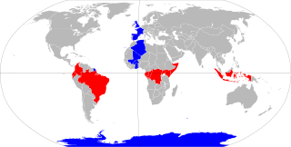
The Antarctic Circle is the most southerly of the five major circles of latitude that mark maps of Earth. The region south of this circle is known as the Antarctic, and the zone immediately to the north is called the Southern Temperate Zone. South of the Antarctic Circle, the Sun is above the horizon for 24 continuous hours at least once per year and the centre of the Sun is below the horizon for 24 continuous hours at least once per year ; this is also true within the equivalent polar circle in the Northern Hemisphere, the Arctic Circle.
The Arctic Circle is one of the two polar circles, and the most northerly of the five major circles of latitude as shown on maps of Earth at about 66° 34' N. Its southern equivalent is the Antarctic Circle.
This page is based on this Wikipedia article Text is available under the CC BY-SA 4.0 license; additional terms may apply. Images, videos and audio are available under their respective licenses.