
In geography, latitude is a coordinate that specifies the north–south position of a point on the surface of the Earth or another celestial body. Latitude is given as an angle that ranges from −90° at the south pole to 90° at the north pole, with 0° at the Equator. Lines of constant latitude, or parallels, run east–west as circles parallel to the equator. Latitude and longitude are used together as a coordinate pair to specify a location on the surface of the Earth.

A geographic coordinate system (GCS) is a spherical or geodetic coordinate system for measuring and communicating positions directly on Earth as latitude and longitude. It is the simplest, oldest and most widely used of the various spatial reference systems that are in use, and forms the basis for most others. Although latitude and longitude form a coordinate tuple like a cartesian coordinate system, the geographic coordinate system is not cartesian because the measurements are angles and are not on a planar surface.
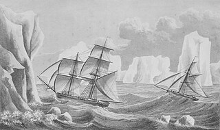
The history of Antarctica emerges from early Western theories of a vast continent, known as Terra Australis, believed to exist in the far south of the globe. The term Antarctic, referring to the opposite of the Arctic Circle, was coined by Marinus of Tyre in the 2nd century AD.

A circle of latitude or line of latitude on Earth is an abstract east–west small circle connecting all locations around Earth at a given latitude coordinate line.

A polar circle is a geographic term for a conditional circular line (arc) referring either to the Arctic Circle or the Antarctic Circle. These are two of the keynote circles of latitude (parallels). On Earth, the Arctic Circle is currently drifting northwards at a speed of about 14.5 m per year and is now at a mean latitude of 66°33′50.1″ N; the Antarctic Circle is currently drifting southwards at a speed of about 14.5 m per year and is now at a mean latitude of 66°33′50.1″ S. Polar circles are often equated with polar regions of Earth. Due to their inherent climate environment, the bulk of the Arctic Circle, much of which is sea, is sparsely settled whereas this applies to all of Antarctica which is mainly land and sheltered ice shelves.

The British Antarctic Territory (BAT) is a sector of Antarctica claimed by the United Kingdom as one of its 14 British Overseas Territories, of which it is by far the largest by area. It comprises the region south of 60°S latitude and between longitudes 20°W and 80°W, forming a wedge shape that extends to the South Pole, overlapped by the Antarctic claims of Argentina and Chile. The claim to the region has been suspended since the Antarctic Treaty came into force in 1961.

The Southern Hemisphere is the half (hemisphere) of Earth that is south of the Equator. It contains all or parts of five continents and four oceans, as well as New Zealand and most of the Pacific Islands in Oceania. Its surface is 80.9% water, compared with 60.7% water in the Northern Hemisphere, and it contains 32.7% of Earth's land.

The universal polar stereographic (UPS) coordinate system is used in conjunction with the universal transverse Mercator (UTM) coordinate system to locate positions on the surface of the Earth. Like the UTM coordinate system, the UPS coordinate system uses a metric-based cartesian grid laid out on a conformally projected surface. UPS covers the Earth's polar regions, specifically the areas north of 84°N and south of 80°S, which are not covered by the UTM grids, plus an additional 30 minutes of latitude extending into UTM grid to provide some overlap between the two systems.
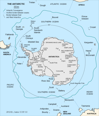
The Antarctic Convergence or Antarctic Polar Front is a marine belt encircling Antarctica, varying in latitude seasonally, where cold, northward-flowing Antarctic waters meet the relatively warmer waters of the sub-Antarctic. Antarctic waters predominantly sink beneath the warmer subantarctic waters, while associated zones of mixing and upwelling create a zone very high in marine productivity, especially for Antarctic krill.
The 30th parallel north is a circle of latitude that is 30 degrees north of the Earth's equatorial plane. It stands one-third of the way between the equator and the North Pole and crosses Africa, Asia, the Pacific Ocean, North America, and the Atlantic Ocean. The parallel is used in some contexts to delineate Europe or what is associated with the continent of Europe as a southernmost limit, e.g. to qualify for membership of the European Broadcasting Union.
The 45th parallel north is a circle of latitude that is 45 degrees north of Earth's equator. It crosses Europe, Asia, the Pacific Ocean, North America, and the Atlantic Ocean. The 45th parallel north is often called the halfway point between the equator and the North Pole, but the true halfway point is 16.0 km (9.9 mi) north of it because Earth is an oblate spheroid; that is, it bulges at the equator and is flattened at the poles.
The Falkland Islands Dependencies was the constitutional arrangement from 1843 until 1985 for administering the various British territories in Sub-Antarctica and Antarctica which were governed from the Falkland Islands and its capital Stanley.

Farthest South refers to the most southerly latitudes reached by explorers before the first successful expedition to the South Pole in 1911.
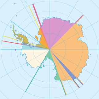
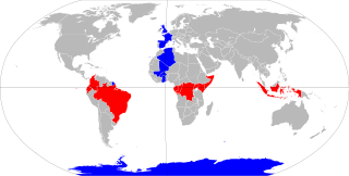
Seven sovereign states – Argentina, Australia, Chile, France, New Zealand, Norway, and the United Kingdom – have made eight territorial claims in Antarctica. These countries have tended to place their Antarctic scientific observation and study facilities within their respective claimed territories; however, a number of such facilities are located outside of the area claimed by their respective countries of operation, and countries without claims such as China, India, Italy, Japan, Pakistan, Russia, South Africa (SANAE), Poland, and the United States have constructed research facilities within the areas claimed by other countries. There are overlaps among the territories claimed by Argentina, Chile, and the United Kingdom.
The 80th parallel north is a circle of latitude that is 80 degrees north of the Earth's equatorial plane, and 10 degrees south of the North Pole, in the Arctic. It crosses the Atlantic Ocean, Europe, Asia, the Arctic Ocean, and North America.
The 70th parallel south is a circle of latitude that is 70 degrees south of the Earth's equatorial plane in the Antarctic. The parallel passes through the Southern Ocean and Antarctica.
The equator is a circle of latitude that divides a spheroid, such as Earth, into the Northern and Southern hemispheres. On Earth, the Equator is an imaginary line located at 0 degrees latitude, about 40,075 km (24,901 mi) in circumference, halfway between the North and South poles. The term can also be used for any other celestial body that is roughly spherical.
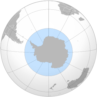
The Southern Ocean, also known as the Antarctic Ocean, comprises the southernmost waters of the world ocean, generally taken to be south of 60° S latitude and encircling Antarctica. With a size of 20,327,000 km2 (7,848,000 sq mi), it is the second-smallest of the five principal oceanic divisions, smaller than the Pacific, Atlantic and Indian oceans, and larger than the Arctic Ocean.
The 75th parallel south is a circle of latitude that is 75 degrees south of the Earth's equatorial plane in the Antarctic. It passes through the Southern Ocean and Antarctica.

Antarctica sits on every line of longitude because the South Pole is on the continent. Theoretically, Antarctica would be located in all time zones; however, areas south of the Antarctic Circle experience extreme day-night cycles near the times of the June and December solstices, making it difficult to determine which time zone would be appropriate. For practical purposes time zones are usually based on territorial claims; however, the time zone of their supply base is often utilised. In most areas south of 80 degrees latitude, Coordinated Universal Time is assumed despite the limited presence of clocks.


