
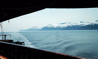
The Alexander Archipelago is a 300-mile (480 km) long archipelago in North America lying off the southeastern coast of Alaska. It contains about 1,100 islands, the tops of submerged coastal mountains that rise steeply from the Pacific Ocean. Deep channels and fjords separate the islands and cut them off from the mainland. The islands shelter the northern part of the Inside Passage as it winds its way among them.

The Dixon Entrance is a strait about 80 kilometers (50 mi) long and wide in the Pacific Ocean at the Canada–United States border, between the U.S. state of Alaska and the province of British Columbia in Canada. The Dixon Entrance is part of the Inside Passage shipping route. It forms part of the maritime boundary between the U.S. and Canada, although the location of that boundary here is disputed.

John Meares was an English navigator, explorer, and maritime fur trader, best known for his role in the Nootka Crisis, which brought Britain and Spain to the brink of war.
Clarence Strait, originally Duke of Clarence Strait, is a strait in southeastern Alaska, in the United States in the Alexander Archipelago. The strait separates Prince of Wales Island, on the west side, from Revillagigedo Island and Annette Island, on the east side. Clarence Strait is 126 miles (203 km) long, extending from Dixon Entrance to Sumner Strait. Moira Sound is on the west side of the strait.

Dall Island is an island in the Alexander Archipelago off the southeast coast of Alaska, just west of Prince of Wales Island and north of Canadian waters. Its peak elevation is 2,443 feet above sea level. Its land area is 254.0 square miles (657.9 km2), making it the 28th largest island in the United States. Dall is used economically for fishing and limestone quarrying.
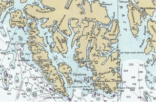
Long Island is an island in the Alexander Archipelago of southeastern Alaska, United States. It lies across the Kaigani Strait from the southern portion of Dall Island and west of the southern part of Prince of Wales Island. Directly to its north is Sukkwan Island. Long Island forms part of the western boundary of Cordova Bay, and has a land area of 116.136 km2 and was unpopulated at the 2000 census.

Milbanke Sound is a sound on the coast of the Canadian province of British Columbia.

Wales Island is an island on the North Coast of British Columbia, Canada, situated east of the Dixon Entrance at the entrance to Portland Inlet.
Zubof Rock is a small island near Sitka, Alaska, United States, off the northeast coast of Baranof Island. Located in an area of Kelp Bay known as The Basin, it was entered into the United States Geological Survey's Geographic Names Information System on March 31, 1981. Its name dates back to 1895 as Zuboff, which was a Russian surname, as reported by Lieutenant Commander J. F. Moser of the United States Navy.

Tongass Island, historically also spelled Tongas Island, is an island in the southern Alaska Panhandle, near the marine boundary with Canada at 54–40 N. It was the site of Fort Tongass, which was established shortly after the Alaska Purchase as a customs port for travelers bound from British Columbian waters to the Stikine River, which was one of the main routes of access to the Cassiar Gold Rush of the 1870s. It lies west of Port Tongass in Nakat Bay, adjacent to the Dixon Entrance and is 0.8 miles in length. Its Native Alaskan name "Kut-tuk-wah" was published in 1869 by the United States Coast and Geodetic Survey; its current name was first published in 1891.

Cordova Bay is a bay in the Alexander Archipelago of southeast Alaska. It opens onto Dixon Entrance to the south, between Cape Muzon on Dall Island and Point Marsh. The name Puerto Cordova y Cordova was given by the Spanish explorer Lieutenant Don Jacinto Caamaño in 1792, in honor of Admiral Luis de Córdova y Córdova. The name was published by George Vancouver in 1798.
Aaron Island is an island in the City and Borough of Juneau, Alaska, United States. It was named by Lester A. Beardslee in 1880. Located in Lynn Canal, it is 1.2 miles (1.9 km) northwest of Point Stephens and 17 miles (27 km) northwest of the city of Juneau.
Benjamin Island is an island in the City and Borough of Juneau, Alaska, United States. It was named by Captain Lester A. Beardslee of the United States Navy in 1880. Located off the eastern shore of Favorite Channel, it is 25 miles (40 km) northwest of the city of Juneau.
Zayas Island is an island on the North Coast of British Columbia, Canada, located in the east side of Dixon Entrance to the west of Dundas Island. Three parcels of land on the north, east and south shores of the island are reserves of the Lax Kw'alaams First Nation.

Ikatan Peninsula is the southeastern extremity of Unimak Island in the U.S. state of Alaska.
Kaigani Strait is a waterway in the U.S. state of Alaska, the southern part of the strait between Long Island and Dall Island. The Alaska Native name, as reported by Etolin is 1833, is Kalgan.
American Bay is a waterway in the U.S. state of Alaska. It is located on the east side of Dall Island, facing Long Island across Kaigani Strait.
Cholmondeley Sound is a deep bay or inlet on the southeast side of Prince of Wales Island, in the Alexander Archipelago of southeast Alaska, in Tongass National Forest and connecting to Clarence Strait. The sound's entrance lies between Chasina Point and Skin Island. It is about 20 miles (32 km) west of Ketchikan, Alaska. Cholmondeley Sound has several bays and inlets within it, including Kitkun Bay, Dora Bay, Brennan Bay, and Sunny Cove. At its western end Cholmondeley Sound splits into two fjord-like inlets: West Arm Chomondeley Sound, about 7.5 miles (12.1 km) long, and South Arm Cholmondeley Sound, about 8 miles (13 km) long. The full length from the entrance of the sound to the head of West Arm is about 16 miles (26 km).

Kaigani was a major trading site for maritime fur traders and the Kaigani Haida during the maritime fur trade era of approximately 1790 to 1850. The term was used for a few nearby anchorages near several Haida settlements such as Kasaan. During this time Kaigani was one of the most popular sites for trading vessels on the Pacific Northwest coast. Hundreds of trading vessels, mostly American, visited during this time, mostly seeking sea otter skins to take to China, where they commanded a high price.
