Cape Breton County

Last updated
Cape Breton County
Comté de Cap-Breton (French)
County
CapebretonCounty.png
Location of Cape Breton County, Nova Scotia
Coordinates: 46°00′N60°18′W / 46.0°N 60.3°W / 46.0; -60.3 Coordinates: 46°00′N60°18′W / 46.0°N 60.3°W / 46.0; -60.3
CountryCanada
Province Nova Scotia
Municipality Cape Breton Regional Municipality
EstablishedDecember 10, 1765
Separated into Colony1784
Reannexed to Nova Scotia1820
IncorporatedApril 17, 1879
AmalgamatedAugust 1, 1995
Electoral Districts   
Federal

Cape Breton—Canso / Sydney—Victoria
Provincial Cape Breton Centre / Cape Breton North / Cape Breton Nova / Cape Breton South / Cape Breton West / Glace Bay
Government
  Mayor-Warden Amanda McDougall
  CouncilCape Breton Regional Council
Area
  Total2,470.62 km2 (953.91 sq mi)
Population
 (2006)
  Total109,330
  Density44.3/km2 (115/sq mi)
Time zone UTC-4 (AST)
Area code 902
Median Earnings*$40,451
  • Median household income, 2000 ($) (all households)

Part of a series about Places in Nova Scotia

Cape Breton County is one of eighteen counties in the Canadian province of Nova Scotia. It is located on Cape Breton Island.

Contents

From 1879 to 1995, the area of the county excluded from towns and cities was incorporated as the Municipality of the County of Cape Breton to provide local government services. Since 1995 the only municipality in the county has been a single-tier municipality called Cape Breton Regional Municipality. For statistical purposes, the First Nations reserves of Eskasoni 3 and Membertou 28B are included in the county, but are separate entities.

History

Taking its name from Cape Breton, the most easterly point of the island which was called after the Bretons of Brittany, the county has what is probably the oldest surviving European name to have been used to designate part of North America.

By proclamation of October 17, 1763 after termination of the Seven Years' War, Cape Breton Island was formally annexed to Nova Scotia. For a time thereafter Cape Breton Island was part of Halifax County. On December 10, 1765, Cape Breton Island was set apart as a separate county under the name Cape Breton County.

From 1784 to 1820, Cape Breton Island was established as a separate colony with a Lieutenant Governor and a nominated Executive Council, but without an elected house of assembly. Not until after Cape Breton Island was re-annexed to Nova Scotia in 1820 did it receive representation in an elected legislature.

Although subdivided into three districts in 1824, Cape Breton County was co-extensive with Cape Breton Island from 1820 to 1835 when the county was divided into three separate and distinct counties:

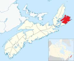
In 1851, Victoria County was formed out of the northeastern part of Cape Breton County and a year later, in 1852, the present boundaries of Cape Breton County were defined by the colonial government in Halifax.

Demographics

As a census division in the 2021 Census of Population conducted by Statistics Canada, Cape Breton County had a population of 98,318 living in 43,799 of its 48,020 total private dwellings, a change of

Transportation

Major highways

Municipal government

Cape Breton County had several incorporated municipalities within its boundaries:

In the early 1990s the provincial government began to examine duplication of municipal services in Nova Scotia. One of the recommendations arising from this study was that all of Cape Breton County be amalgamated. On August 1, 1995 all seven municipal units in the county were dissolved and replaced by a single tier municipality called the Cape Breton Regional Municipality (CBRM).

The new regional municipality's boundary included all of Cape Breton County except for the Eskasoni and Membertou First Nations.

Cape Breton County continues to exist as a county in Nova Scotia, but all municipal government and service delivery is provided by either the Cape Breton Regional Municipality or the First Nations, with no additional county level government or administration or any lower-level town or city-level government or administration.

Communities

Regional municipalities
Reserves

Related Research Articles

<span class="mw-page-title-main">Cape Breton Island</span> Island in Nova Scotia

Cape Breton Island is an island on the Atlantic coast of North America and part of the province of Nova Scotia, Canada.

<span class="mw-page-title-main">Nova Scotia</span> Province of Canada

Nova Scotia is one of the thirteen provinces and territories of Canada. It is one of the three Maritime provinces and one of the four Atlantic provinces. Nova Scotia is Latin for "New Scotland".

<span class="mw-page-title-main">Sydney, Nova Scotia</span> Place in Nova Scotia, Canada

Sydney is a former city and urban community on the east coast of Cape Breton Island in Nova Scotia, Canada within the Cape Breton Regional Municipality. Sydney was founded in 1785 by the British, was incorporated as a city in 1904, and dissolved on 1 August 1995, when it was amalgamated into the regional municipality.

<span class="mw-page-title-main">Halifax County, Nova Scotia</span> County in Nova Scotia, Canada

Halifax County is a county in the Canadian province of Nova Scotia. The Municipality of the County of Halifax was the municipal government of Halifax County, apart from the separately incorporated towns and cities therein. The municipality was dissolved in 1996, together with those town and city governments, in their amalgamation into Halifax Regional Municipality.

<span class="mw-page-title-main">Port Hawkesbury</span> Town in Nova Scotia, Canada

Port Hawkesbury is a municipality in southern Cape Breton Island, Nova Scotia, Canada. While within the historical county of Inverness, it is not part of the Municipality of Inverness County.

<span class="mw-page-title-main">Cape Breton Regional Municipality</span> Municipality in Nova Scotia, Canada

Cape Breton Regional Municipality is the Canadian province of Nova Scotia's second largest municipality and the economic heart of Cape Breton Island. As of 2016 the municipality has a population of 94,285. The municipality was created in 1995 through the amalgamation of eight municipalities located in Cape Breton County.

<span class="mw-page-title-main">Central Nova</span> Federal electoral district in Nova Scotia, Canada

Central Nova is a federal electoral district in Nova Scotia, Canada that was represented in the House of Commons of Canada from 1968 until 1996. In 1996, Antigonish County and part of Guysborough County were placed with Pictou County in a new electoral boundaries configuration to form the electoral district of Pictou-Antigonish-Guysborough. A new version of Central Nova was established in 2003 and — in conjunction with the Pictou-Antigonish-Guysborough iteration — represented a significant electoral boundaries change with specific reference to Antigonish County. Between 1867 and 1997, Antigonish County was not in a riding that included Pictou County; rather, it comprised either its own electoral district (Antigonish), or part of other districts shared with Eastern Nova Scotia (Antigonish-Guysborough) and Cape Breton Island communities. In 2013, part of Antigonish County was "placed back" with communities in the electoral district of Cape Breton Canso, a riding which had emerged in part from the former Cape Breton Highlands Canso riding in 1996. The current version of Central Nova includes Pictou County, parts of Antigonish and Guysborough Counties and extends into Halifax Regional Municipality.

<span class="mw-page-title-main">Nova Scotia Highway 125</span> Highway in Nova Scotia

Highway 125 is a 28 km long controlled-access highway located in Nova Scotia's Cape Breton Regional Municipality. The provincial government named it Peacekeepers Way on August 18, 2008. Part of the provincial 100-series arterial highway network, Highway 125 encircles the west side of Sydney Harbour, from an interchange with Highway 105 at Sydney Mines to Trunk 4 immediately east of Sydney.

The Membertou First Nation is a Mi'kmaq First Nation band government in the tribal district of Unama'ki, also known as Cape Breton Island, Nova Scotia. As of 2012, the Mi'kmaq population is 814 on-Reserve, and approximately 481 off-Reserve. It operates a community radio station CJIJ-FM. Currently, Membertou has become the most well-off First Nation in Atlantic Canada.

<span class="mw-page-title-main">Nova Scotia Junior Hockey League</span>

The Nova Scotia Junior Hockey League is a Junior "B" ice hockey league in Nova Scotia, Canada, sanctioned by Hockey Canada. The winner of the Nova Scotia playoffs competes for the Don Johnson Cup, the Atlantic Junior "B" Crown.

Route 216 is a collector road in the Canadian province of Nova Scotia.

Route 327 is a collector road in the Canadian province of Nova Scotia.

<span class="mw-page-title-main">Amalgamation of the Halifax Regional Municipality</span>

The amalgamation of four municipalities on April 1, 1996, was the creation of the Halifax Regional Municipality, Nova Scotia, Canada. It resulted in the regional municipality's current boundaries.

<span class="mw-page-title-main">Cape Breton East</span> Provincial electoral district in Nova Scotia, Canada

Cape Breton East is a provincial electoral district in Nova Scotia, Canada, that elects one member of the Nova Scotia House of Assembly. The riding is represented by Brian Comer of the Progressive Conservative Party.

<span class="mw-page-title-main">Outline of Nova Scotia</span> Overview of and topical guide to Nova Scotia

The following outline is provided as an overview of and topical guide to Nova Scotia:

<span class="mw-page-title-main">Greenlink Rotary Park Trail System</span> Urban park in Sydney, Nova Scotia, Canada

Greenlink Rotary Park Trail System is a Canadian urban park located in the community of Sydney, part of Nova Scotia's Cape Breton Regional Municipality. The park incorporates the Greenlink Trail System, the Rotary Park Off Leash Park, as well as a disc golf course. Much of the park is forested, with ponds, a stone dam, and streams in the valleys; a few acres are open lawn area, suitable for informal recreation. The park encompass 52 acres (21 ha) within the former city's boundaries.

<span class="mw-page-title-main">2020 Nova Scotia municipal elections</span>

Municipal elections were held in the Canadian province of Nova Scotia on October 17, 2020. Here is a summary of the mayoral results in the largest municipalities in the province and the council results for Cape Breton and Kings County. Elections were also held for the Conseil scolaire acadien provincial school board.

<span class="mw-page-title-main">Administrative divisions of Nova Scotia</span> Local governance within Nova Scotia

The Canadian province of Nova Scotia is divided into 49 municipalities, of which there are three types: regional (4), town (25), and county or district municipality (20).

References

  1. "Population and dwelling counts: Canada and census divisions". Statistics Canada. February 9, 2022. Retrieved April 2, 2022.