
Cape Breton Regional Municipality, often referred to as simply CBRM, is the Canadian province of Nova Scotia's second largest municipality and the economic heart of Cape Breton Island. As of 2016 the municipality has a population of 94,285. The municipality was created in 1995 through the amalgamation of eight municipalities located in Cape Breton County.
Cape Breton South was a federal electoral district in the province of Nova Scotia, Canada, that was represented in the House of Commons of Canada from 1904 to 1911 and from 1925 to 1968.
Highway 104 in Nova Scotia, Canada, runs from Fort Lawrence at the New Brunswick border near Amherst to River Tillard near St. Peter's. Except for the portion on Cape Breton Island between Port Hawkesbury and St. Peter's, it forms the main route of the Trans-Canada Highway across the province.
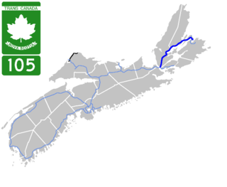
Highway 105 in Nova Scotia represents the Cape Breton Island leg of the Trans-Canada Highway. It runs from the Port Hastings Rotary just east of the Canso Causeway in Port Hastings to the Marine Atlantic ferry terminal in North Sydney, representing a distance of 142 kilometres (88 mi).

Highway 125 is a 28 km long controlled-access highway located in Nova Scotia's Cape Breton Regional Municipality. The provincial government named it Peacekeepers Way on August 18, 2008. Part of the provincial 100-series arterial highway network, Highway 125 encircles the west side of Sydney Harbour, from an interchange with Highway 105 at Sydney Mines to Trunk 4 immediately east of Sydney.

Trunk 1 is part of the Canadian province of Nova Scotia's system of Trunk Highways.
Trunk 4 is part of the Canadian province of Nova Scotia's system of Trunk Highways. The route runs from Highway 104 exit 7 near Thomson Station to Glace Bay. Until the construction of the Trans-Canada Highway, Trunk 4 was a major traffic link in northern Nova Scotia and Cape Breton, and is still used on Cape Breton as an alternative to Highway 105. The highway was originally called the King's Highway, however, this name is no longer applied to the entire road. The only remaining historic section of the highway that maintains the name "King" is King's Road in Sydney.
Trunk 28 is part of the Canadian province of Nova Scotia's system of trunk highways. The route runs from Sydney to Glace Bay, a distance of 36 kilometres (22 mi).
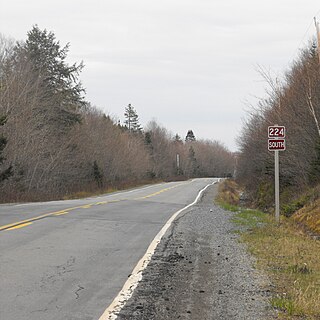
Route 224 is a collector road in the Canadian province of Nova Scotia. It is located in the Halifax Regional Municipality and Colchester County, connecting Sheet Harbour at Trunk 7 with Milford Station at Exit 9 of Highway 102 and Trunk 14. The route passes through the upper half of the Musquodoboit Valley.
Route 204 is a collector road in the Canadian province of Nova Scotia.
Route 215 is collector road in the Canadian province of Nova Scotia.
Route 368 is a collector road in the Canadian province of Nova Scotia.

Route 236 is a collector road in the Canadian province of Nova Scotia.
Route 223 is a collector road in the Canadian province of Nova Scotia.
Route 305 is a collector road in the Canadian province of Nova Scotia.

Sgurra Bhreac, sometimes referred to as the Big Rock, is a Canadian peak in the East Bay Hills of Cape Breton Island, an extension of the Appalachian mountain chain in the province of Nova Scotia. Sgurra Bhreac is a prominent rock outcrop, rising 50 m (160 ft) from the northern edge of The Big Barren, between the Breac Brook and Glengarry Valleys, and is the highest point on Cape Breton Island south of the Bras d'Or Lake with its summit at 222 m (728 ft).

Gabarus is a community in the Canadian province of Nova Scotia, located in the Cape Breton Regional Municipality. It was an important fisheries centre with a cannery until the mid-20th century. Today, it is sustained by tourism and small-scale commercial fishing, including lobster.
Gabarus Lake is a community in the Canadian province of Nova Scotia, located in the Cape Breton Regional Municipality.

Sydney River-Mira-Louisbourg is a provincial electoral district in Nova Scotia, Canada, that elects one member of the Nova Scotia House of Assembly. The riding is represented by Brian Comer of the Progressive Conservative Party.