Nova Scotia Route 357

Last updated

Nova Scotia Route 357.svg

Route 357
Route information
Maintained by Nova Scotia Department of Transportation and Infrastructure Renewal
Length 39 km [1] (24 mi)
Major junctions
South endNova Scotia 7.svg Trunk 7 in Musquodoboit Harbour
 Nova Scotia Route 212.svg Route 212 in Elderbank
North endNova Scotia Route 224.svg Route 224 in Middle Musquodoboit
Highway system

Provincial highways in Nova Scotia

Nova Scotia Route 354.svg Route 354 Route 358 Nova Scotia Route 358.svg

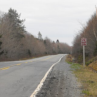
Route 357 is a collector road in the Canadian province of Nova Scotia. It is located in the Halifax Regional Municipality and connects Musquodoboit Harbour at Trunk 7 with Middle Musquodoboit at Route 224 .

Canada Country in North America

Canada is a country in the northern part of North America. Its ten provinces and three territories extend from the Atlantic to the Pacific and northward into the Arctic Ocean, covering 9.98 million square kilometres, making it the world's second-largest country by total area. Canada's southern border with the United States, stretching some 8,891 kilometres (5,525 mi), is the world's longest bi-national land border. Its capital is Ottawa, and its three largest metropolitan areas are Toronto, Montreal, and Vancouver. As a whole, Canada is sparsely populated, the majority of its land area being dominated by forest and tundra. Consequently, its population is highly urbanized, with over 80 percent of its inhabitants concentrated in large and medium-sized cities, with 70% of citizens residing within 100 kilometres (62 mi) of the southern border. Canada's climate varies widely across its vast area, ranging from arctic weather in the north, to hot summers in the southern regions, with four distinct seasons.

Nova Scotia Province of Canada

Nova Scotia is one of Canada's three Maritime Provinces, and one of the four provinces that form Atlantic Canada. Its provincial capital is Halifax. Nova Scotia is the second-smallest of Canada's ten provinces, with an area of 55,284 square kilometres (21,300 sq mi), including Cape Breton and another 3,800 coastal islands. As of 2016, the population was 923,598. Nova Scotia is Canada's second-most-densely populated province, after Prince Edward Island, with 17.4 inhabitants per square kilometre (45/sq mi).

Musquodoboit Harbour, Nova Scotia community in Nova Scotia, Canada

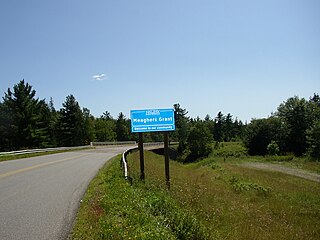
Musquodoboit Harbour is a Canadian rural community in Nova Scotia's Halifax Regional Municipality. The community is situated on the Eastern Shore at the mouth of the Musquodoboit River. The community lies 45 kilometres east of downtown Halifax. With a hospital, RCMP detachment, postal outlet, schools, recreational center, library, municipal office and other services, Musquodoboit Harbour is a serve centre for many of the surrounding communities.

Contents

It closely follows the Musquodoboit River.

Nova Scotia Route 357 NSRoute357.jpg
Nova Scotia Route 357

Communities

Meaghers Grant, Nova Scotia

Meaghers Grant is a rural community in the Musquodoboit Valley region of the eastern Halifax Regional Municipality Nova Scotia on Route 357. The community is located on the Musquodoboit River and the economy is mainly farming and forestry. It is approximately 45 minutes away from Halifax, the province's capital city. The River Oaks Golf course is located there.

Gibraltar, Nova Scotia

Gibraltar is a rural community of the Halifax Regional Municipality in the Canadian province of Nova Scotia on Nova Scotia Route 357, approximately 15 km north of Musquodoboit Harbour.

Elderbank, Nova Scotia

Elderbank is a farming community in the Musquodoboit Valley area of the Halifax Regional Municipality, Nova Scotia at the junction of Routes 357 and 212. Elderbank is located in the Southeast Branch Musquodoboit. Other communities in this branch include, Meaghers Grant, Nova Scotia.

Parks

Gibraltar Rock Provincial Park Reserve is a park and trail in Gibraltar in the Musquodoboit Valley in the Halifax Regional Municipality of Nova Scotia.

See also

Related Research Articles

Nova Scotia Highway 107 highway in Nova Scotia

Highway 107 in Nova Scotia runs through the eastern suburbs of the Halifax Regional Municipality, from the Burnside Industrial Park in Dartmouth to an intersection with Trunk 7 in Musquodoboit Harbour. It is 41 km (25 mi) long, and is mostly two lane, controlled access highway.

The Eastern Shore is a region of the Canadian province of Nova Scotia. It is the Atlantic coast running northeast from Halifax Harbour to the eastern end of the peninsula at the Strait of Canso.

Musquodoboit River river in Canada

The Musquodoboit River is a Canadian river located in central Nova Scotia in the northeastern part of Halifax Regional Municipality. The river is approximately 97 kilometres (60 mi) in length with roughly 88 kilometres (55 mi) being traversable by paddle. It has a watershed area of 1,409 square kilometres (544 sq mi)

Nova Scotia Trunk 7 is part of the Canadian province of Nova Scotia's system of Trunk Highways. The route runs from Bedford to Antigonish, along the Eastern Shore for a distance of 269 kilometres (167 mi). Part of Trunk 7 is known as the Marine Drive.

The Marine Drive is a designated scenic route along Nova Scotia's Eastern Shore. It closely follows the coast of the Atlantic Ocean and the Strait of Canso from the Canso Causeway to the junction of Route 322 and Highway 111 in Dartmouth.

Route 212 is a collector road in the Canadian province of Nova Scotia.

Nova Scotia Route 224 highway in Nova Scotia

Route 224 is a collector road in the Canadian province of Nova Scotia. It is located in the Halifax Regional Municipality and Colchester County, connecting Sheet Harbour at Trunk 7 with Milford Station at Exit 9 of Highway 102 and Trunk 14. The route passes through the upper half of the Musquodoboit Valley.

Route 289 is a collector road in the Canadian province of Nova Scotia.

Route 336 is a collector road in the Canadian province of Nova Scotia.

Route 344 is a collector road in the Canadian province of Nova Scotia.

Dollar Lake Provincial Park is a seasonal Provincial Park located in the Musquodoboit Valley area of the Halifax Regional Municipality in Nova Scotia, Canada in the community of Wyses Corner, Nova Scotia, 22 kilometres from the Halifax International Airport, on the Old Guysborough Road.

Middle Musquodoboit, Nova Scotia Rural Community in Nova Scotia, Canada

Middle Musquodoboit is a farming community in the Musquodoboit Valley region of the Halifax Regional Municipality, along the Musquodoboit River at the junction of Route 357 with Route 224, 78 kilometres (48 mi) from Dartmouth, Nova Scotia. The community's name comes from the First Nations' word Mooskoduboogwek, which means to suddenly widen out after a narrow entrance at a mouth. For a time after 1883, Middle Musquodoboit was called Laytonville, but at some point reverted to its former name.

Transportation in Halifax, Nova Scotia

Halifax, Nova Scotia, is a major multi-modal transportation centre for freight and passengers in Atlantic Canada.

The Capital District Health Authority was the largest of the nine health authorities in the Canadian province of Nova Scotia. In 2015 it was merged into the new, province-wide Nova Scotia Health Authority.

Sheet Harbour Road, Nova Scotia community in the Regional Municipality of Halifax in Nova Scotia, Canada

Sheet Harbour Road is a community of the Halifax Regional Municipality in the Canadian province of Nova Scotia. It is located just five minutes south of Upper Musquodoboit, Nova Scotia. Its name is derived from Route 224, which is the primary route from the Musquodoboit Valley to Sheet Harbour, Nova Scotia.

References

  1. Atlantic Canada Back Road Atlas ISBN   978-1-55368-618-7 Pages 69, 82