Highway 104 in Nova Scotia, Canada, runs from Fort Lawrence at the New Brunswick border near Amherst to River Tillard near St. Peter's. Except for the portion on Cape Breton Island between Port Hawkesbury and St. Peter's, it forms the main route of the Trans-Canada Highway across the province.
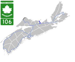
Highway 106 is a 19 km (12 mi) 2-lane limited-access highway located within Pictou County, in the Canadian province of Nova Scotia. The provincial government named the highway the Jubilee Highway on December 21, 2012 in honour of Queen Elizabeth II's Diamond Jubilee.

Caledonia, Nova Scotia is a community located in northern Region of Queens Municipality, Nova Scotia along Trunk 8. Caledonia is the major community in the area known as North Queens, which has a radius of approximately 30 kilometers and a population of approximately 1500.

Nova Scotia Trunk 7 is part of the Canadian province of Nova Scotia's system of Trunk Highways. The route runs from Bedford to Antigonish, along the Eastern Shore for a distance of 269 kilometres (167 mi). Part of Trunk 7 is known as the Marine Drive.

Trunk 1 is part of the Canadian province of Nova Scotia's system of Trunk Highways.

Trunk 2 is part of the Canadian province of Nova Scotia's system of Trunk Highways. The route runs from Halifax to Fort Lawrence on the New Brunswick border. Until the 1960s, Trunk 2 was the Halifax area's most important highway link to other provinces, and was part of a longer Interprovincial Highway 2 which ended in Windsor, Ontario. The controlled access Highway 102 and Highway 104 now carry most arterial traffic in the area, while Trunk 2 serves regional and local traffic.
Route 374 is a collector road in the Canadian province of Nova Scotia. It connects New Glasgow at Exit 24 of Nova Scotia Highway 104 with Sheet Harbour at Trunk 7. The highway runs through the Halifax Regional Municipality, Guysborough County & Pictou County.

Trunk 4 is part of the Canadian province of Nova Scotia's system of Trunk Highways. The route runs from Highway 104 exit 7 near Thomson Station to Glace Bay. Until the construction of the Trans-Canada Highway, Trunk 4 was a major traffic link in northern Nova Scotia and Cape Breton, and is still used on Cape Breton as an alternative to Highway 105. The highway was originally called the King's Highway, however, this name is no longer applied to the entire road. The only remaining historic section of the highway that maintains the name "King" is King's Road in Sydney.

Trunk 6 is part of the Canadian province of Nova Scotia's system of trunk highways. The route runs from Highway 104 exit 3 at Amherst to the rotary at Pictou, a distance of 136 kilometres (85 mi). It is part of the Sunrise Trail, a designated tourist route.

Trunk 12 is part of the Canadian province of Nova Scotia's system of Trunk Highways. The route runs from Chester Basin to Kentville, a distance of 66 kilometres (41 mi).
Route 289 is a collector road in the Canadian province of Nova Scotia.
Route 368 is a collector road in the Canadian province of Nova Scotia.

Route 302 is a collector road in the Canadian province of Nova Scotia.
Route 312 is a collector road in the Canadian province of Nova Scotia.
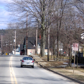
Route 325 is a collector road in the Canadian province of Nova Scotia. It is located in Lunenburg County and connects Colpton at Route 208 with Mahone Bay at Trunk 3.
Brookfield is a Canadian rural community located in southern Colchester County, Nova Scotia, Canada. Brookfield is a growing community in the heart of Nova Scotia, just forty minutes from the provincial capital of Halifax, thirty minutes from the Stanfield International Airport and ten minutes from the Town of Truro. The community hosts both levels of public schools, two churches, restaurants, a bakery, a service station, a sportsplex, an 18 hole golf course, and a volunteer fire service.
The Cobequid Pass is the name given to a 45 km (28 mi) tolled section of Nova Scotia Highway 104 between Thomson Station, Cumberland County and Masstown, Colchester County in the Canadian province of Nova Scotia. The section is a public–private partnership; the highway is owned by the Highway 104 Western Alignment Corporation, a Crown corporation of the Government of Nova Scotia, with a toll plaza operated under contract by Atlantic Highway Management Corporation Limited, a subsidiary of Aecon Concessions. The toll plaza is located near the halfway point in Londonderry. It opened in 1997.
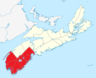
Southern Nova Scotia or the South Shore is a region of Nova Scotia, Canada. The area has no formal identity and is variously defined by geographic, county and other political boundaries. Statistics Canada, defines Southern Nova Scotia as an economic region, composed of Lunenburg County, Queens County, Shelburne County, Yarmouth County, and Digby County. According to Statistics Canada, the region had the highest decrease of population in Canada from 2009 to 2010, with a population decrease of 10.2 residents per thousand. The region also has the second-highest median age in Canada at 47.1 years old.