
Bedford is a provincial electoral district in Nova Scotia, Canada, that elects one member of the Nova Scotia House of Assembly. Its current Member of the Legislative Assembly is Kelly Regan.
The Eastern Shore is a region of the Canadian province of Nova Scotia. It is the Atlantic coast running northeast from Halifax Harbour to the eastern end of the peninsula at the Strait of Canso.

The Musquodoboit River is a Canadian river located in central Nova Scotia in the northeastern part of Halifax Regional Municipality. The river is approximately 97 kilometres (60 mi) in length with roughly 88 kilometres (55 mi) being traversable by paddle. It has a watershed area of 1,409 square kilometres (544 sq mi)
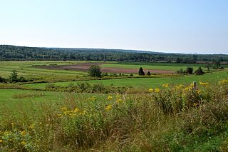
The Musquodoboit Valley is a valley and region in the Halifax Regional Municipality of Nova Scotia, Canada. It is administratively located in the municipality's Musquodoboit Valley & Dutch Settlement planning area and the western edge of the valley includes communities that are considered part of the commutershed for the urban area of the Halifax Regional Municipality. The picturesque Musquodoboit River flows through majority of the valley, passing by most of the communities in the valley. The river is approximately 97 kilometres (60 mi) long and originates in the extreme northeastern area of the valley. The three largest communities in the valley are Upper Musquodoboit, Middle Musquodoboit and Musquodoboit Harbour. The word "Musquodoboit" is derived from the Mi’kmaq language and means "rolling out in foam".
Nova Scotia Trunk 7 is part of the Canadian province of Nova Scotia's system of Trunk Highways. The route runs from Bedford to Antigonish, along the Eastern Shore for a distance of 269 kilometres (167 mi). Part of Trunk 7 is known as the Marine Drive.
Trunk 14 is part of the Canadian province of Nova Scotia's system of Trunk Highways. The route runs from Chester to Milford Station through the Windsor area, for a distance of 121 kilometres (75 mi).
The Marine Drive is a designated scenic route along Nova Scotia's Eastern Shore. It closely follows the coast of the Atlantic Ocean and the Strait of Canso from the Canso Causeway to the junction of Route 322 and Highway 111 in Dartmouth.
Route 212 is a collector road in the Canadian province of Nova Scotia.

Route 357 is a collector road in the Canadian province of Nova Scotia. It is located in the Halifax Regional Municipality and connects Musquodoboit Harbour at Trunk 7 with Middle Musquodoboit at Route 224.
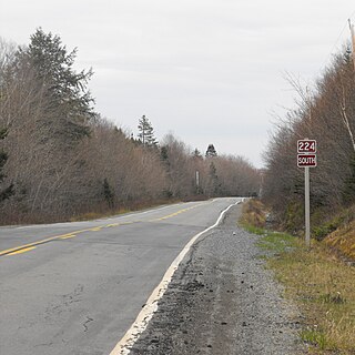
Route 224 is a collector road in the Canadian province of Nova Scotia. It is located in the Halifax Regional Municipality and Colchester County, connecting Sheet Harbour at Trunk 7 with Milford Station at Exit 9 of Highway 102 and Trunk 14. The route passes through the upper half of the Musquodoboit Valley.
Route 289 is a collector road in the Canadian province of Nova Scotia.
Dollar Lake Provincial Park is a seasonal Provincial Park located in the Musquodoboit Valley area of the Halifax Regional Municipality in Nova Scotia, Canada in the community of Wyses Corner, Nova Scotia, 22 kilometres from the Halifax International Airport, on the Old Guysborough Road.

Middle Musquodoboit is a farming community in the Musquodoboit Valley region of the Halifax Regional Municipality, along the Musquodoboit River at the junction of Route 357 with Route 224, 78 kilometres (48 mi) from Dartmouth, Nova Scotia. The community's name comes from the First Nations' word Mooskoduboogwek, which means to suddenly widen out after a narrow entrance at a mouth. For a time after 1883, Middle Musquodoboit was called Laytonville, but at some point reverted to its former name.

Upper Musquodoboit is a forestry and farming community in the northeastern reaches of the Musquodoboit Valley, in the Halifax Regional Municipality, Nova Scotia, Canada, 75 kilometres (47 mi) from Downtown Halifax. The community is located along the Musquodoboit River. The community had a population of 473 at the 2006 Census and the community has an area of 380.25 square kilometres (146.82 sq mi). Upper Musquodoboit is situated at the junction of Route 336 with Route 224.

Dean is a small farming & forestry community in the North Branch Musquodoboit in the Musquodoboit Valley along the Halifax Regional Municipality/Colchester County county line, in the Canadian province of Nova Scotia, along Route 336. Other communities in the North Branch include Elmsvale, Greenwood, Upper Musquodoboit, and Moose River Gold Mines, among others.
Musquodoboit Harbour is a Canadian rural community in Nova Scotia's Halifax Regional Municipality. The community is situated on the Eastern Shore at the mouth of the Musquodoboit River. The community lies 45 kilometres east of downtown Halifax. With a hospital, RCMP detachment, postal outlet, schools, recreational center, library, municipal office and other services, Musquodoboit Harbour is a serve centre for many of the surrounding communities.
Sheet Harbour Road is a community of the Halifax Regional Municipality in the Canadian province of Nova Scotia. It is located just five minutes south of Upper Musquodoboit, Nova Scotia. Its name is derived from Route 224, which is the primary route from the Musquodoboit Valley to Sheet Harbour, Nova Scotia.
The Musquodoboit Trailway is a 14.5-kilometre-long (9.0 mi) multi-use rail trail located in Halifax County, Nova Scotia, running the distance from Gibralter to Musquodoboit Harbour. The entire route is part of the Halifax spur of The Great Trail, and follows Nova Scotia Route 357 for its length.

The Eastern Shore Granite Ridge, also known as the Musquodoboit Batholith, is a range of prominent hills averaging 100-125m (330-410ft) in height, located just inland from the Eastern Shore of Nova Scotia. Geologically, it is related to the much larger South Mountain Batholith, but the two are geologically distinct areas. Many of the hills have steep cliffs on one or more of their sides, some featuring vertical drops in excess of 50m (160ft); as a result, many of the taller hills offer extensive views despite their relatively low elevation.

The Eastern Shore is a tourism region of the province of Nova Scotia, Canada. It provides two percent of the revenue for the province's tourism economy. One of its key features is an archipelago known as the 100 Wild Islands area.
