Nova Scotia Route 312

Last updated

Nova Scotia Route 312.svg

Route 312
Route information
Maintained by Nova Scotia Department of Transportation and Infrastructure Renewal
Length 13 km [1] (8 mi)
Major junctions
South endNova Scotia Highway 105 (TCH).png Hwy 105 (TCH) in South Haven
North endNova Scotia 30.svg Trunk 30 in River Bennet
Location
Counties Victoria
Highway system

Provincial highways in Nova Scotia

Nova Scotia Route 311.svg Route 311 Route 316 Nova Scotia Route 316.svg

Route 312 is a collector road in the Canadian province of Nova Scotia.

Canada Country in North America

Canada is a country in the northern part of North America. Its ten provinces and three territories extend from the Atlantic to the Pacific and northward into the Arctic Ocean, covering 9.98 million square kilometres, making it the world's second-largest country by total area. Canada's southern border with the United States, stretching some 8,891 kilometres (5,525 mi), is the world's longest bi-national land border. Its capital is Ottawa, and its three largest metropolitan areas are Toronto, Montreal, and Vancouver. As a whole, Canada is sparsely populated, the majority of its land area being dominated by forest and tundra. Consequently, its population is highly urbanized, with over 80 percent of its inhabitants concentrated in large and medium-sized cities, with 70% of citizens residing within 100 kilometres (62 mi) of the southern border. Canada's climate varies widely across its vast area, ranging from arctic weather in the north, to hot summers in the southern regions, with four distinct seasons.

Nova Scotia Province of Canada

Nova Scotia is one of Canada's three Maritime Provinces, and one of the four provinces that form Atlantic Canada. Its provincial capital is Halifax. Nova Scotia is the second-smallest of Canada's ten provinces, with an area of 55,284 square kilometres (21,300 sq mi), including Cape Breton and another 3,800 coastal islands. As of 2016, the population was 923,598. Nova Scotia is Canada's second-most-densely populated province, after Prince Edward Island, with 17.4 inhabitants per square kilometre (45/sq mi).

Contents

It is located in Victoria County and connects Englishtown at Highway 105 with River Bennet at Trunk 30 (the Cabot Trail).

Victoria County, Nova Scotia County in Nova Scotia, Canada

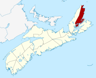
Victoria County is a county in Nova Scotia, Canada. The shire town and largest municipality is the village of Baddeck.

Englishtown, Nova Scotia human settlement

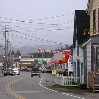
Englishtown is a small coastal community in the Canadian province of Nova Scotia, located partially on St. Ann's Harbour as well as St. Ann's Bay in Victoria County on Cape Breton Island. It is predominantly a fishing community.

Nova Scotia Highway 105 highway in Nova Scotia

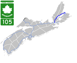
Highway 105 in Nova Scotia represents the Cape Breton Island leg of the Trans-Canada Highway. It runs from the Port Hastings Rotary just east of the Canso Causeway in Port Hastings to the Marine Atlantic ferry terminal in North Sydney, representing a distance of 142 kilometres (88 mi).

Communities

See also

Related Research Articles

Oxford, Nova Scotia Town in Nova Scotia, Canada

Oxford is a town in Cumberland County, Nova Scotia, Canada 32 km (20 mi) east of Amherst. The town is directly serviced by Routes 104, 204, 301, and 321. Oxford is the only town in Nova Scotia that doesn't provide its' tax paying citizens with garbage collection.

St. Peters, Nova Scotia Village in Nova Scotia, Canada

St. Peter's is a small incorporated village located on Cape Breton Island in Richmond County, Nova Scotia, Canada.

Nova Scotia Highway 103 highway in Nova Scotia

Highway 103 is an east-west highway in Nova Scotia that runs from Halifax to Yarmouth.

Nova Scotia Trunk 7 is part of the Canadian province of Nova Scotia's system of Trunk Highways. The route runs from Bedford to Antigonish, along the Eastern Shore for a distance of 269 kilometres (167 mi). Part of Trunk 7 is known as the Marine Drive.

Trunk 10 is part of the Canadian province of Nova Scotia's system of Trunk Highways. This rural road runs from Bridgewater to Middleton, a distance of 89 kilometres.

Route 214 is a short collector road in the Canadian province of Nova Scotia.

Route 204 is a collector road in the Canadian province of Nova Scotia.

Nova Scotia Route 209 highway in Nova Scotia

Route 209 is a collector road in the Canadian province of Nova Scotia.

Route 395 is a collector road in the Canadian province of Nova Scotia.

Route 376 is a collector road in the Canadian province of Nova Scotia.

Nova Scotia Route 316 highway in Nova Scotia

Route 316 is a collector road in the Canadian province of Nova Scotia. It is located in Antigonish County and Guysborough County, connecting Lower South River at Highway 104 with Half Island Cove at Trunk 16.

Route 242 is a collector road in the Canadian province of Nova Scotia.


Route 245 is a collector road in the Canadian province of Nova Scotia. Route 245 is part of the Sunrise Trail.

Nova Scotia Route 321 highway in Nova Scotia

Route 321 is a collector road in the Canadian province of Nova Scotia.

Nova Scotia Route 256 highway in Nova Scotia

Route 256 is a collector road in the Canadian province of Nova Scotia.

Route 305 is a collector road in the Canadian province of Nova Scotia.

Nova Scotia Route 309 highway in Nova Scotia

Route 309 is a collector road in the Canadian province of Nova Scotia.

Nova Scotia Route 311 highway in Nova Scotia

Route 311 is a collector road in the Canadian province of Nova Scotia.

Fort Sainte Anne (Nova Scotia)

Fort Ste. Anne was a former French military fort located at present-day Englishtown, Victoria County, Nova Scotia, Canada.

References

  1. Atlantic Canada Back Road Atlas ISBN   978-1-55368-618-7 Page 42