Nova Scotia Route 302

Last updated

Nova Scotia Route 302.svg

Nova Scotia Route 302
NSRoute302 Athol 2011.jpg
Route 302 passes through Athol, Nova Scotia.
Route information
Maintained by Nova Scotia Department of Transportation and Infrastructure Renewal
Length23 km [1] (14 mi)
Major junctions
South endNova Scotia 2.svg Trunk 2 in Southampton
 Nova Scotia Route 242.svg Route 242 in Maccan
North endNova Scotia 2.svg Trunk 2 in Upper Nappan
Location
Counties Cumberland
Highway system
Provincial highways in Nova Scotia
100-series
Nova Scotia Route 301.svg Route 301 Route 303 Nova Scotia Route 303.svg

Route 302 is a collector road in the Canadian province of Nova Scotia.

Contents

It is in Cumberland County and connects Amherst at Trunk 2 with Southampton at Trunk 2. It is designated as part of the Fundy Shore Scenic Drive. [2]

Communities

History

Nova Scotia 2A.svg

Trunk 2A
Location SouthamptonUpper Nappan
Length15 km (9.3 mi)

The entirety of Collector Highway 302 was originally part of and older westerly route of Trunk Highway 2, [3] but was re-designated as Trunk Highway 2A when Trunk 2 was realigned. [4] The route also intersected former Trunk 26 in Athol, now named Little Forks Road.

See also

Related Research Articles

Cabot Trail highway in Nova Scotia

The Cabot Trail is a highway and scenic roadway in northern Victoria County and Inverness County on Cape Breton Island in Nova Scotia, Canada.

Nova Scotia Trunk 1 Highway in Nova Scotia

Trunk 1 is part of the Canadian province of Nova Scotia's system of Trunk Highways.

Trunk 2 is part of the Canadian province of Nova Scotia's system of Trunk Highways. The route runs from Halifax to Fort Lawrence on the New Brunswick border. Until the 1960s, Trunk 2 was the Halifax area's most important highway link to other provinces, and was part of a longer Interprovincial Highway 2 which ended in Windsor, Ontario. The controlled access Highway 102 and Highway 104 now carry most arterial traffic in the area, while Trunk 2 serves regional and local traffic.

Route 322 is a collector road in the Canadian province of Nova Scotia.

Route 318 is a collector road in the Canadian province of Nova Scotia.

Nova Scotia Route 333 highway in Nova Scotia

Route 333 is a collector road in the Canadian province of Nova Scotia.

Nova Scotia Route 217 highway in Nova Scotia

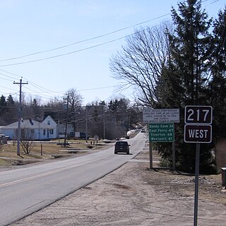
Route 217 is a collector road in the Canadian province of Nova Scotia.

Nova Scotia Route 209 highway in Nova Scotia

Route 209 is a collector road in the Canadian province of Nova Scotia.

Route 216 is a collector road in the Canadian province of Nova Scotia.

Route 219 is a collector road approximately 20.3 km long in the Canadian province of Nova Scotia.

Route 376 is a collector road in the Canadian province of Nova Scotia.

Nova Scotia Route 221 highway in Nova Scotia

Route 221 is a collector road in the Canadian province of Nova Scotia.

Route 242 is a collector road in the Canadian province of Nova Scotia.


Route 245 is a collector road in the Canadian province of Nova Scotia. Route 245 is part of the Sunrise Trail.

Nova Scotia Route 321 highway in Nova Scotia

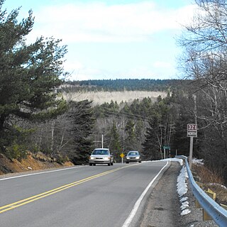
Route 321 is a collector road in the Canadian province of Nova Scotia.

Nova Scotia Route 246 highway in Nova Scotia

Route 246 is a collector road in the Canadian province of Nova Scotia.

Route 320 is a collector road in the Canadian province of Nova Scotia.

Nova Scotia Route 325 highway in Nova Scotia

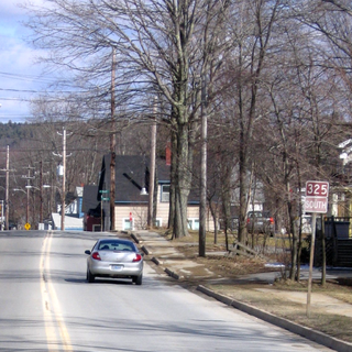
Route 325 is a collector road in the Canadian province of Nova Scotia. It is located in Lunenburg County and connects Colpton at Route 208 with Mahone Bay at Trunk 3.

Nova Scotia Route 341 highway in Nova Scotia

Route 341 is a collector road in the Canadian province of Nova Scotia.

References

  1. Atlantic Canada Back Road Atlas ISBN   978-1-55368-618-7 Pages 50-51
  2. Scenic Roadways Locator Map (PDF) (Map). 1:1,100,000. Province of Nova Scotia. 2019.
  3. Province of Nova Scotia (1944). Official Road Map (Map). Province of Nova Scotia, Canada's Ocean Playground.
  4. Surveys and Mapping Branch, Department of Mines and Technical Surveys (1966). "Highways of Canada and Northern United States - Eastern Sheet" (Map). Canada and Northern United States. 1 in = 150 mi. Ottawa: Canadian Government Travel Bureau.