Pictou County is a county in the province of Nova Scotia, Canada. It was established in 1835, and was formerly a part of Halifax County from 1759 to 1835. It had a population of 43,748 people in 2016, a decline of 4.2 percent from 2011. Furthermore, its 2016 population is only 88.11% of the census population in 1991. It is the sixth most populous county in Nova Scotia.
Highway 104 in Nova Scotia, Canada, runs from Fort Lawrence at the New Brunswick border near Amherst to River Tillard near St. Peter's. Except for the portion on Cape Breton Island between Port Hawkesbury and St. Peter's, it forms the main route of the Trans-Canada Highway across the province.
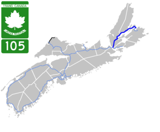
Highway 105 in Nova Scotia represents the Cape Breton Island leg of the Trans-Canada Highway. It runs from the Port Hastings Rotary just east of the Canso Causeway in Port Hastings to the Marine Atlantic ferry terminal in North Sydney, representing a distance of 142 kilometres (88 mi).
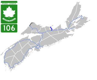
Highway 106 is a 19 km (12 mi) 2-lane limited-access highway located within Pictou County, in the Canadian province of Nova Scotia.

Highway 107 in Nova Scotia runs through the eastern suburbs of the Halifax Regional Municipality, from the Burnside Industrial Park in Dartmouth to an intersection with Trunk 7 in Musquodoboit Harbour. It is 43.2 km (26.8 mi) long, and is mostly two lane, controlled access highway.
Nova Scotia Trunk 7 is part of the Canadian province of Nova Scotia's system of Trunk Highways. The route runs from Bedford to Antigonish, along the Eastern Shore for a distance of 269 kilometres (167 mi). Part of Trunk 7 is known as the Marine Drive.

Trunk 1 is part of the Canadian province of Nova Scotia's system of Trunk Highways.
Trunk 2 is part of the Canadian province of Nova Scotia's system of Trunk Highways. The route runs from Halifax to Fort Lawrence on the New Brunswick border. Until the 1960s, Trunk 2 was the Halifax area's most important highway link to other provinces, and was part of a longer Interprovincial Highway 2 which ended in Windsor, Ontario. The controlled access Highway 102 and Highway 104 now carry most arterial traffic in the area, while Trunk 2 serves regional and local traffic.
Trunk 4 is part of the Canadian province of Nova Scotia's system of Trunk Highways. The route runs from Highway 104 exit 7 near Thomson Station to Glace Bay. Until the construction of the Trans-Canada Highway, Trunk 4 was a major traffic link in northern Nova Scotia and Cape Breton, and is still used on Cape Breton as an alternative to Highway 105. The highway was originally called the King's Highway, however, this name is no longer applied to the entire road. The only remaining historic section of the highway that maintains the name "King" is King's Road in Sydney.
Trunk 28 is part of the Canadian province of Nova Scotia's system of trunk highways. The route runs from Sydney to Glace Bay, a distance of 36 kilometres (22 mi).
Trunk 6 is part of the Canadian province of Nova Scotia's system of trunk highways. The route runs from Highway 104 exit 3 at Amherst to the rotary at Pictou, a distance of 136 kilometres (85 mi). It is part of the Sunrise Trail, a designated tourist route.
Trunk 12 is part of the Canadian province of Nova Scotia's system of Trunk Highways. The route runs from Chester Basin to Kentville, a distance of 66 kilometres (41 mi).
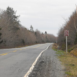
Route 224 is a collector road in the Canadian province of Nova Scotia. It is located in the Halifax Regional Municipality and Colchester County, connecting Sheet Harbour at Trunk 7 with Milford Station at Exit 9 of Highway 102 and Trunk 14. The route passes through the upper half of the Musquodoboit Valley.
Route 289 is a collector road in the Canadian province of Nova Scotia.
Route 204 is a collector road in the Canadian province of Nova Scotia.
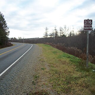
Route 316 is a collector road in the Canadian province of Nova Scotia. It is located in Antigonish County and Guysborough County, connecting Lower South River at Highway 104 with Half Island Cove at Trunk 16.

Route 302 is a collector road in the Canadian province of Nova Scotia.
Route 348 is a collector road in the Canadian province of Nova Scotia.

The East River Bridge is a multi-span bridge in Sheet Harbour, Nova Scotia that carries Trunk 7 and the Marine Drive scenic route over the Northeast Arm of Sheet Harbour. The bridge is 183 m (600 ft) in length and was constructed from September 2014 to December 2015. It was opened on December 17, 2015 to pedestrians, with a bridge walk commemorating the closing of the old bridge and the opening of the new bridge. The bridge was opened to vehicles the day after. It replaced a green steel arch bridge of the same name that was built in 1956 immediately north of the current bridge. The previous bridge had a span of 213 m (699 ft) and shared engineering ties with the Angus L. MacDonald Bridge in Halifax. Nova Scotia was considering repairs to the old bridge, but they ultimately elected to construct a new bridge instead. The current bridge was designed without overhead arches, unlike its predecessor, as the construction cost would have been doubled.
