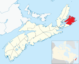
Cape Breton County is one of eighteen counties in the Canadian province of Nova Scotia. It is located on Cape Breton Island.
Cape Breton South was a federal electoral district in the province of Nova Scotia, Canada, that was represented in the House of Commons of Canada from 1904 to 1911 and from 1925 to 1968.

The Sydney and Louisburg Railway (S&L) was a Canadian railway. Built to transport coal from various mines to the ports of Sydney and Louisbourg, the S&L operated in the eastern part of Cape Breton County, Nova Scotia. The railway uses a slightly different spelling for the town of "Louisbourg".

The Marconi National Historic Site and the Marconi Wireless Station National Historic Site are two National Historic Sites located on Cape Breton Island, Nova Scotia. Both sites commemorate the efforts of Guglielmo Marconi to transmit transatlantic radio signals between North America and Europe in the first decade of the 20th century. The two sites are located within approximately 8 kilometres (5.0 mi) of one another, and are connected by the Marconi Trail.
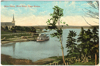
The Mira River is a Canadian river located in eastern Cape Breton Island, Nova Scotia.
Nova Scotia Trunk 7 is part of the Canadian province of Nova Scotia's system of Trunk Highways. The route runs from Bedford to Antigonish, along the Eastern Shore for a distance of 269 kilometres (167 mi). Part of Trunk 7 is known as the Marine Drive.
Trunk 2 is part of the Canadian province of Nova Scotia's system of Trunk Highways. The route runs from Halifax to Fort Lawrence on the New Brunswick border. Until the 1960s, Trunk 2 was the Halifax area's most important highway link to other provinces, and was part of a longer Interprovincial Highway 2 which ended in Windsor, Ontario. The controlled access Highway 102 and Highway 104 now carry most arterial traffic in the area, while Trunk 2 serves regional and local traffic.
Nova Scotia Trunk 3 is an east-west trunk highway in Nova Scotia. The route runs from Halifax to Yarmouth, along the South Shore. Trunk 3's status as an important regional highway link has been superseded by the parallel Highway 103.
Trunk 4 is part of the Canadian province of Nova Scotia's system of Trunk Highways. The route runs from Highway 104 exit 7 near Thomson Station to Glace Bay. Until the construction of the Trans-Canada Highway, Trunk 4 was a major traffic link in northern Nova Scotia and Cape Breton, and is still used on Cape Breton as an alternative to Highway 105. The highway was originally called the King's Highway, however, this name is no longer applied to the entire road. The only remaining historic section of the highway that maintains the name "King" is King's Road in Sydney.
Trunk 28 is part of the Canadian province of Nova Scotia's system of trunk highways. The route runs from Sydney to Glace Bay, a distance of 36 kilometres (22 mi).
Trunk 6 is part of the Canadian province of Nova Scotia's system of trunk highways. The route runs from Highway 104 exit 3 at Amherst to the rotary at Pictou, a distance of 136 kilometres (85 mi). It is part of the Sunrise Trail, a designated tourist route.
Trunk 22 is part of the Canadian province of Nova Scotia's system of trunk highways. The route runs from Sydney to Louisbourg, a distance of 36 kilometres (22 mi).
The Marconi Trail is a scenic roadway in the Canadian province of Nova Scotia.
The Glooscap Trail is a scenic roadway in the Canadian province of Nova Scotia.
Donkin is a Canadian rural village with a population of 532 as of 2021. Located on the picturesque coastline of Nova Scotia's Cape Breton Island, it is a part of the Cape Breton Regional Municipality. The smaller communities of Port Caledonia and Schooner Pond are directly adjacent to the village proper, connected by a single strip of road called the Donkin Highway.
Adam Brown Crosby was a politician in Nova Scotia, Canada.
Port Morien is a small fishing community of 700 people in the Canadian province of Nova Scotia, located in the southeastern Cape Breton Island near the rural community Donkin, and six miles from the town of Glace Bay.
Weldon Wood Patton was a Canadian politician. He represented the electoral district of Cape Breton West in the Nova Scotia House of Assembly from 1933 to 1937. He was a member of the Conservative Party of Nova Scotia.