Nova Scotia Route 253

Last updated

Nova Scotia Route 253.svg

Route 253
Route information
Maintained by Nova Scotia Department of Transportation and Infrastructure Renewal
Length 12 km [1] (7 mi)
Major junctions
South endNova Scotia Route 349.svg Route 349 in Herring Cove
North endNova Scotia Route 349.svg Route 349 in Armdale
Highway system

Provincial highways in Nova Scotia

Nova Scotia Route 252.svg Route 252 Route 255 Nova Scotia Route 255.svg

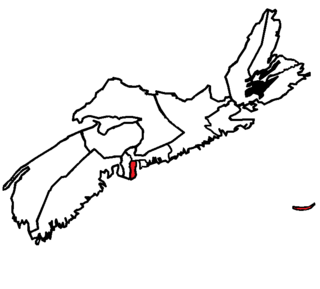
Nova Scotia Route 253 is a collector road in the Canadian province of Nova Scotia.

Canada Country in North America

Canada is a country in the northern part of North America. Its ten provinces and three territories extend from the Atlantic to the Pacific and northward into the Arctic Ocean, covering 9.98 million square kilometres, making it the world's second-largest country by total area. Canada's southern border with the United States, stretching some 8,891 kilometres (5,525 mi), is the world's longest bi-national land border. Its capital is Ottawa, and its three largest metropolitan areas are Toronto, Montreal, and Vancouver. As a whole, Canada is sparsely populated, the majority of its land area being dominated by forest and tundra. Consequently, its population is highly urbanized, with over 80 percent of its inhabitants concentrated in large and medium-sized cities, with 70% of citizens residing within 100 kilometres (62 mi) of the southern border. Canada's climate varies widely across its vast area, ranging from arctic weather in the north, to hot summers in the southern regions, with four distinct seasons.

Nova Scotia Province of Canada

Nova Scotia is one of Canada's three Maritime Provinces, and one of the four provinces that form Atlantic Canada. Its provincial capital is Halifax. Nova Scotia is the second-smallest of Canada's ten provinces, with an area of 55,284 square kilometres (21,300 sq mi), including Cape Breton and another 3,800 coastal islands. As of 2016, the population was 923,598. Nova Scotia is Canada's second-most-densely populated province, after Prince Edward Island, with 17.4 inhabitants per square kilometre (45/sq mi).

Contents

It is located in the Halifax Regional Municipality and connects Armdale with Herring Cove. The route generally parallels the eastern coast of the Chebucto Peninsula.

Herring Cove, Nova Scotia community in Nova Scotia, Canada

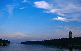
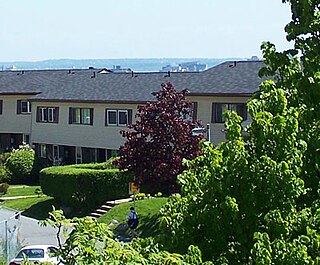
Herring Cove is a Canadian suburban and former fishing community in Nova Scotia's Halifax Regional Municipality. It is situated on the eastern shore of the Chebucto Peninsula, 15 kilometres south of Downtown Halifax. It is near the western approaches to Halifax Harbour, and can be reached both via Purcell's Cove along the coastal road and from inland via the Herring Cove Road through Spryfield. There are two schools in Herring Cove, William King Elementary and Herring Cove Junior High. The community is also home to a small variety of small businesses and programs.

Chebucto Peninsula

The Chebucto Peninsula is a Canadian peninsula located in central Nova Scotia entirely within the Halifax Regional Municipality on the Atlantic coast.

Between the junction with Route 349 in Armdale and Fortress Drive in Ferguson's Cove, it is known as Purcell's Cove Road. Afterwards and until Village Road in Herring Cove, it is known as John Brackett Drive. The last stretch in Herring Cove is known as Hebridean Drive.

Fergusons Cove, Nova Scotia human settlement in Nova Scotia, Canada

Ferguson's Cove is a suburban community within the Halifax Regional Municipality Nova Scotia on the western shore of Halifax Harbour between Purcell's Cove and Herring Cove along Route 253. The first 3 digits of the postal code in the area are B3V.

Communities

View north on Route 253 near York Redoubt. Nova Scotia Route 253 in Purcell's Cove May 2010.JPG
View north on Route 253 near York Redoubt.
Purcells Cove, Nova Scotia

Purcell's Cove is a community within the Halifax Regional Municipality, Nova Scotia, Canada, on the west side of Halifax Harbour from the Northwest Arm to Ferguson's Cove along Route 253.

List of parks

Provincial

Federal

Municipal

Yacht clubs

See also

Related Research Articles

Halifax (electoral district) Federal electoral district

Halifax is a federal electoral district in Nova Scotia, Canada, is one of a handful of ridings which has been represented continuously in the House of Commons since Confederation in 1867.

Spryfield, Nova Scotia

Spryfield is an unincorporated suburban community in Halifax, Nova Scotia, Canada. It was founded about 1770, by Captain William Spry, who purchased land there and established the settlement with the aid of stationed soldiers from the nearby Halifax garrison. In 1783, he sold the property and returned to England. The name "Spryfield" is also sometimes used to refer to the general area of Halifax's South Mainland, which includes a number of communities along the Herring Cove and Purcell's Cove Roads.

Mainland Halifax Community in Nova Scotia, Canada

Mainland Halifax is a community and planning area in central Nova Scotia, Canada that refers to the central-eastern part of the Chebucto Peninsula in the Halifax Regional Municipality. It contrasts with Halifax Peninsula, which lies across the Northwest Arm.

Northwest Arm bay in Nova Scotia, Canada

The Northwest Arm, originally named Sandwich River, is an inlet in eastern Canada off the Atlantic Ocean in Nova Scotia's Halifax Regional Municipality.

Armdale is a neighbourhood of Halifax, Nova Scotia, Canada.

Halifax Harbour Harbor in Canada

Halifax Harbour is a large natural harbour on the Atlantic coast of Nova Scotia, Canada, located in the Halifax Regional Municipality.

The Armdale Rotary is a roundabout in the Armdale district of Halifax, Nova Scotia.

Nova Scotia Route 333 highway in Nova Scotia

Route 333 is a collector road in the Canadian province of Nova Scotia.

Route 349 is collector road in the Canadian province of Nova Scotia.


Route 245 is a collector road in the Canadian province of Nova Scotia. Route 245 is part of the Sunrise Trail.

Route 344 is a collector road in the Canadian province of Nova Scotia.

Nova Scotia Route 331 highway in Nova Scotia

Route 331 is a collector road in the Canadian province of Nova Scotia.

Route 329 is a collector road in the Canadian province of Nova Scotia.

Cowie Hill human settlement in Nova Scotia, Canada

Cowie Hill is a subdivision of Mainland Halifax in the Halifax Regional Municipality, Nova Scotia. The hill on which it is situated was originally called "Cowie's Hill", named after one of the original owners of the land, Robert Cowie. Cowie was a British merchant, who was granted the land in 1752 by Governor Edward Cornwallis. Over time, the apostrophe 's' in "Cowie's Hill" was dropped.

McGraths Cove, Nova Scotia

McGraths Cove is a rural fishing community located near Peggy's Cove in the western part of the Halifax Regional Municipality, Nova Scotia, on Route 333. McGraths Cove is a quiet community on the water, and home to friendly locals always with welcoming faces. At the end of McGraths Cove Road, the Atlantic Ocean can be seen as far as the eye can see. A true symbol of Nova Scotia heritage is greatly displayed in this beautiful cove.

Chocolate Lake lake in Nova Scotia, Canada

Chocolate Lake is located in the Armdale neighbourhood of Halifax, Nova Scotia. The lake is surrounded by many private homes as well as a Best Western hotel and a city beach. As one of the nearest freshwater lakes to Downtown Halifax, Chocolate Lake is popular with swimmers and families during the summer months.

Halifax Armdale

Halifax Armdale is a provincial electoral district in Nova Scotia, Canada, that elects one member of the Nova Scotia House of Assembly. This Halifax district covers the growing population of the Fairmount, Armdale and Cowie Hill areas. The northern boundary is Highway 102, the eastern boundary is Joseph Howe Drive and the Northwest Arm, while the southern boundary is Frog Pond Park in Armdale.

Route 100 is a major highway in Newfoundland and Labrador. The highway begins at its northern terminus at the Trans-Canada Highway in the town of Whitbourne, runs for 108 kilometres until it ends at its southern terminus, the town of Branch, where it transitions into Route 92. Motorists can drive along the coast of Placentia Bay and eventually the Atlantic Ocean once traveling south of Point Verde.

References

  1. Atlantic Canada Back Road Atlas ISBN   978-1-55368-618-7 Page 81