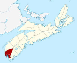
Yarmouth County is a rural county in the Canadian province of Nova Scotia. It has both traditional Anglo-Scottish and Acadian French culture as well as significant inland wilderness areas, including over 365 lakes and several major rivers. It comprises three municipalities: the Town of Yarmouth, the Municipality of the District of Yarmouth, and the Municipality of the District of Argyle.
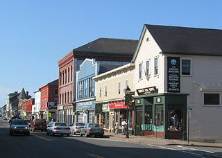
Yarmouth is a town in southwestern Nova Scotia, Canada. A port town, its industries include fishing and tourism. It is the terminus of a ferry service to Bar Harbor, Maine, run by Bay Ferries.

The Halifax and South Western Railway was a historic Canadian railway operating in the province of Nova Scotia.
Highway 103 is an east-west highway in Nova Scotia that runs from Halifax to Yarmouth.

Yarmouth, officially named the Municipality of the District of Yarmouth, is a district municipality in Yarmouth County, Nova Scotia, Canada. Statistics Canada classifies the district municipality as a municipal district.

The 100-Series Highways are a series of arterial highways in the Canadian province of Nova Scotia.
Route 203 is a collector road in the Canadian province of Nova Scotia.

White Juan is the unofficial name given to the hurricane-strength nor'easter blizzard of February 2004 that affected most of Atlantic Canada and the Eastern United States between February 17 and 20, 2004—five months after Hurricane Juan devastated Nova Scotia and Prince Edward Island.

The Cape Forchu Lighthouse is located in Cape Forchu, Nova Scotia. The lighthouse is located 11 km from Yarmouth, Nova Scotia.

Cape Chignecto Provincial Park is a Canadian provincial park located in Nova Scotia. A wilderness park, it derives its name from Cape Chignecto, a prominent headland which divides the Bay of Fundy with Chignecto Bay to the north and the Minas Channel leading to the Minas Basin to the east. The park, which opened in 1998, is the largest provincial park in Nova Scotia. It also anchors one end of the UNESCO Cliffs of Fundy Global Geopark.

The Yarmouth County Museum & Archives is a museum located in Yarmouth, Nova Scotia, Canada. This museum explores the history of Yarmouth County. Located in the heart of Yarmouth's heritage residential district, the museum is housed in a former church as well as two historic houses. It also operates a summer display in the restored Killam Brothers Shipping Office on the Yarmouth waterfront.
New Yarmouth is an abandoned farming and forestry community which is now part of the Cape Chignecto Provincial Park in Cumberland County, Nova Scotia near the village of Advocate.
Johns Cove is a small bay located on the Cape Forchu peninsula in the Municipality of Yarmouth, Nova Scotia. The cove is located in Yarmouth Sound and until the cancellation of the service in 2009 the CAT Ferry could be seen arriving and departing Yarmouth Harbour. Johns Cove is located 4 kilometers away from the town of Yarmouth. The beach is a popular destination for residents from Yarmouth due to its close proximity.

The following outline is provided as an overview of and topical guide to Nova Scotia:

The Yarmouth Stone, also known as the Yarmouth Runic Stone or the Fletcher Stone, is a slab of quartzite that first came to the attention of the public in the early 19th century. The stone appears to have an inscription carved into it which investigators have interpreted as Norse runes, Japanese, Basque. or early Greek This has led to speculation that the Yarmouth, Nova Scotia area, in Canada, was visited by Viking explorers sometime around 1000 C.E. Many other theories have been put forward, including the possibility of a hoax or the inscription being a product of natural forces. The stone is currently on display at the Yarmouth County Museum.
The Raid on Yarmouth took place on 5 December 1775 during the American Revolutionary War. The raid involved American Privateers from Salem, Massachusetts attacking Yarmouth, Nova Scotia at Cape Forchu. The privateers intended to stop the export of supplies being sent from Nova Scotia to the loyalists in Boston.
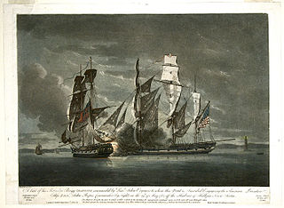
The Province of Nova Scotia was heavily involved in the American Revolutionary War (1776–1783). At that time, Nova Scotia also included present-day New Brunswick until that colony was created in 1784. The Revolution had a significant impact on shaping Nova Scotia, "almost the 14th American Colony". At the beginning, there was ambivalence in Nova Scotia over whether the colony should join the Americans in the war against Britain. Largely as a result of American privateer raids on Nova Scotia villages, as the war continued, the population of Nova Scotia solidified their support for the British. Nova Scotians were also influenced to remain loyal to Britain by the presence of British military units, judicial prosecution by the Nova Scotia Governors and the efforts of Reverend Henry Alline.
Eliza Ann Ross, née McGray (1849–1940), is a Canadian woman best known for commanding the steel four-mast barquentine Reform.
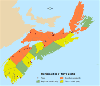
The Canadian province of Nova Scotia is divided into 49 municipalities, of which there are three types: regional (4), town (25), and county or district municipality (20).