
Cole Harbour is a former unincorporated village and unincorporated community located in the Halifax Regional Municipality in Nova Scotia, Canada.

Highway 107 in Nova Scotia runs through the eastern suburbs of the Halifax Regional Municipality, from the Burnside Industrial Park in Dartmouth to an intersection with Trunk 7 in Musquodoboit Harbour. It is 43.2 km (26.8 mi) long, and is mostly two lane, controlled access highway.
The Eastern Shore is a region of the Canadian province of Nova Scotia. It is the Atlantic coast running northeast from Halifax Harbour to the eastern end of the peninsula at the Strait of Canso.
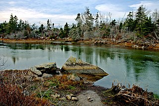
Cole Harbour is the name for a natural harbour located in the Canadian province of Nova Scotia.
Nova Scotia Trunk 7 is part of the Canadian province of Nova Scotia's system of Trunk Highways. The route runs from Bedford to Antigonish, along the Eastern Shore for a distance of 269 kilometres (167 mi). Part of Trunk 7 is known as the Marine Drive.
Route 322 is a collector road in the Canadian province of Nova Scotia.
Route 328 is a short collector road in the Canadian province of Nova Scotia.
Route 318 is a collector road in the Canadian province of Nova Scotia.

Mineville, Nova Scotia is a suburban community within the Eastern Halifax Regional Municipality, Nova Scotia, Canada, between Lake Echo on Trunk 7, Highway 107 and Upper Lawrencetown on Route 207. The main road is called the Mineville Rd. The other road is called Candy Mountain Road. The community has two lakes: Lawrencetown Lake and Lake Echo.
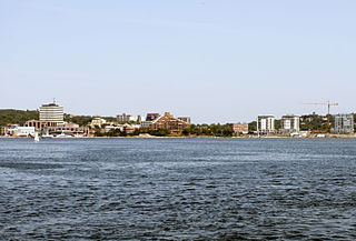
Downtown Dartmouth is the main business, banking and government office core of Dartmouth in Halifax, Nova Scotia. It is part of the Capital District of the Province.
The Marine Drive is a designated scenic route along Nova Scotia's Eastern Shore. It closely follows the coast of the Atlantic Ocean and the Strait of Canso from the Canso Causeway to the junction of Route 322 and Highway 111 in Dartmouth.
Westphal is an unincorporated suburban and rural community located in Dartmouth, Nova Scotia and outside of Dartmouth, Nova Scotia. Some of Westphal is considered part of Dartmouth, Nova Scotia and some of it is considered separate from Dartmouth, Nova Scotia. The area is bound by Port Wallace in the north, Waverley Road in the west, Lake Major Road in the east and Main Street in the south. The area also includes the watershed and water filtration plant for the Halifax Regional Water Commission that supplies drinking water for the residents of Dartmouth and surrounding communities east of Halifax Harbour. It is named after two Westphal brothers who became admirals in the British navy and who hailed from this part of Nova Scotia - George Augustus Westphal and his elder brother Philip. Their surname is of German origin.
West Lawrencetown is a residential community within the Halifax Regional Municipality Nova Scotia on the Eastern Shore on Route 207 along the scenic route Marine Drive.
East Lawrencetown is a rural community within Halifax Regional Municipality in Nova Scotia, Canada on the Eastern Shore on Route 207 along the scenic route Marine Drive. The community is 22.4 kilometers from Halifax. Lawrencetown Beach Provincial Park is located in the community, at the southern end of Lawrencetown Lake, a natural ocean inlet. The beach is a year-round destination for surfing, attracting both locals and those from abroad. There are also places to park vehicles, stroll along boardwalks, hike, mountain bike and swim. Available to the public in the summer is a canteen, showers, flush toilets and a section of beach that is supervised by the Nova Scotia Lifeguard Service.
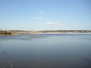
Porters Lake is a rural community in the Eastern Shore region of the Halifax, Nova Scotia, Canada, between Trunk 7 and Route 207, 27.8 km from Halifax. The residents mainly commute to jobs in Dartmouth, Burnside Industrial Park or in Downtown Halifax. The community is built around the lake from which it takes its name.
Three Fathom Harbour is a fishing community on the Eastern Shore of the Halifax Regional Municipality Nova Scotia on the shore of Atlantic Ocean off Route 207 on Three Fathom Harbour Road. The harbour had its own authority.
Head of Chezzetcook is a rural community on the Eastern Shore Marine Drive route of Halifax Regional Municipality in Nova Scotia. The Head of Chezzetcook area begins at the intersections of routes 7 and 207, near Porters Lake and West Chezzetcook, and continues along the Marine Drive to Gaetz Brook. Head of Chezzetcook is a short commute to Downtown Halifax at 29.52 kilometers; and in its heyday was a major port of call for ships delivering supplies from the city to local gold miners and early settlers. A vista of the sea marks the Head of Chezzetcook Inlet, for which the Chezzetcooks are named; and a fork in the road for both East Chezzetcook and Conrod Settlement.

