Nova Scotia Route 219

Last updated

Nova Scotia Route 219.svg

Route 219
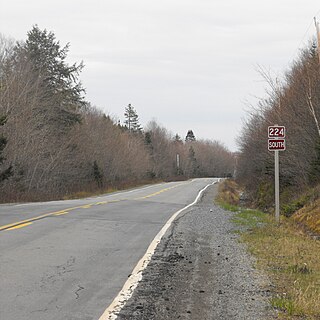
Part of Nova Scotia's Ceilidh Trail
Route information
Maintained by Nova Scotia Department of Transportation and Infrastructure Renewal
Length 20.0 km [1] (12.4 mi)
Major junctions
South endNova Scotia 19.svg Trunk 19 in Dunvegan
North end Cabot Trail in Margaree Harbour
Location
Counties Inverness
Highway system

Provincial highways in Nova Scotia

Nova Scotia Route 217.svg Route 217 Route 221 Nova Scotia Route 221.svg

Route 219 is a collector road approximately 20.3 km long in the Canadian province of Nova Scotia.

Canada Country in North America

Canada is a country in the northern part of North America. Its ten provinces and three territories extend from the Atlantic to the Pacific and northward into the Arctic Ocean, covering 9.98 million square kilometres, making it the world's second-largest country by total area. Canada's southern border with the United States, stretching some 8,891 kilometres (5,525 mi), is the world's longest bi-national land border. Its capital is Ottawa, and its three largest metropolitan areas are Toronto, Montreal, and Vancouver. As a whole, Canada is sparsely populated, the majority of its land area being dominated by forest and tundra. Consequently, its population is highly urbanized, with over 80 percent of its inhabitants concentrated in large and medium-sized cities, with 70% of citizens residing within 100 kilometres (62 mi) of the southern border. Canada's climate varies widely across its vast area, ranging from arctic weather in the north, to hot summers in the southern regions, with four distinct seasons.

Nova Scotia Province of Canada

Nova Scotia is one of Canada's three Maritime Provinces, and one of the four provinces that form Atlantic Canada. Its provincial capital is Halifax. Nova Scotia is the second-smallest of Canada's ten provinces, with an area of 55,284 square kilometres (21,300 sq mi), including Cape Breton and another 3,800 coastal islands. As of 2016, the population was 923,598. Nova Scotia is Canada's second-most-densely populated province, after Prince Edward Island, with 17.4 inhabitants per square kilometre (45/sq mi).

Contents

It is located in Inverness County and connects Margaree Harbour at Trunk 30 (the Cabot Trail) with Dunvegan at Trunk 19.

Inverness County, Nova Scotia County in Nova Scotia, Canada

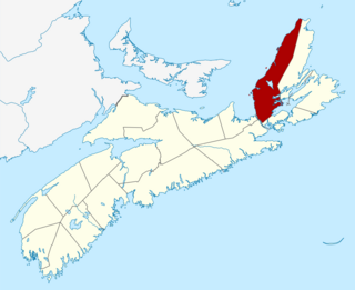
Inverness County is a county in the Canadian province of Nova Scotia. Its territory is almost contiguous with the Municipality of Inverness County, which only excludes the town of Port Hawkesbury and Miꞌkmaq reserves.

Margaree Harbour, Nova Scotia human settlement in Nova Scotia, Canada

Margaree Harbour is a small community in the Canadian province of Nova Scotia, located in Inverness County on Cape Breton Island.

Cabot Trail highway in Nova Scotia

The Cabot Trail is a highway and scenic roadway in northern Victoria County and Inverness County on Cape Breton Island in Nova Scotia, Canada.

The road is designated as part of the Ceilidh Trail.

The Ceilidh Trail is a scenic roadway in the Canadian province of Nova Scotia.

Communities

Dunvegan, Nova Scotia human settlement in Nova Scotia, Canada

Dunvegan is a small community in the Canadian province of Nova Scotia, located in Inverness County on Cape Breton Island.

St. Rose, Nova Scotia human settlement in Nova Scotia, Canada

St. Rose is a small community in the Canadian province of Nova Scotia, located in Inverness County on Cape Breton Island.

Chimney Corner, Nova Scotia human settlement in Nova Scotia, Canada

Chimney Corner is a small community in the Canadian province of Nova Scotia, located in Inverness County on Cape Breton Island.

See also

Related Research Articles

Port Hood, Nova Scotia human settlement in Inverness County, Nova Scotia, Canada

Port Hood is a Canadian community on the west coast of Cape Breton Island and the shire town of Inverness County, Nova Scotia, Canada. Local residents are predominantly English-speaking Roman Catholics, the population core having Scottish Highlands ancestry; MacDonalds/MacDonnells mostly. The community is named after Samuel Hood, 1st Viscount Hood.

Margaree River river in Canada

The Margaree River is a river on Cape Breton Island in Nova Scotia. The northeast branch of the river derives from the watershed of the Cape Breton Highlands, while the Southwest Margaree flows northeast from Lake Ainslie. The two branches join at Margaree Forks. The river then flows north to empty into the Gulf of Saint Lawrence at Margaree Harbour, Nova Scotia. The river is 120 km in length and drains an area of 1,375 km². The Margaree has been well known for a century for its trout and Atlantic salmon sport fishery, that draws anglers from near and far. Fishing is highly regulated now and is restricted to fly fishing only, with barbless hooks, in the main stem of the river. Famed American angler and Atlantic salmon conservationist Lee Wulff caught his first salmon on a fly on the Margaree in 1933.

Nova Scotia Trunk 7 is part of the Canadian province of Nova Scotia's system of Trunk Highways. The route runs from Bedford to Antigonish, along the Eastern Shore for a distance of 269 kilometres (167 mi). Part of Trunk 7 is known as the Marine Drive.

Route 322 is a collector road in the Canadian province of Nova Scotia.

Route 374 is a collector road in the Canadian province of Nova Scotia. It connects New Glasgow at Exit 24 of Nova Scotia Highway 104 with Sheet Harbour at Trunk 7. The highway runs through the Halifax Regional Municipality, Guysborough County & Pictou County.

Trunk 19 is part of the Canadian province of Nova Scotia's system of trunk highways. The road runs from Port Hastings to a junction with the Cabot Trail at Margaree Forks on Cape Breton Island, a distance of 106 kilometres. Most of the route is known as the Ceilidh Trail.

Nova Scotia Route 224 highway in Nova Scotia

Route 224 is a collector road in the Canadian province of Nova Scotia. It is located in the Halifax Regional Municipality and Colchester County, connecting Sheet Harbour at Trunk 7 with Milford Station at Exit 9 of Highway 102 and Trunk 14. The route passes through the upper half of the Musquodoboit Valley.

Nova Scotia Route 211 highway in Nova Scotia

Route 211 is a collector road in the Canadian province of Nova Scotia. It is located in Guysborough County and connects Stillwater on Trunk 7 to Isaac's Harbour North on Route 316.

Route 395 is a collector road in the Canadian province of Nova Scotia.

Route 344 is a collector road in the Canadian province of Nova Scotia.

Route 330 is a collector road in the Canadian province of Nova Scotia.

Nova Scotia Route 359 highway in Nova Scotia

Route 359 is a collector road in the Canadian province of Nova Scotia.

Alexander William Chisholm was a Canadian physician and political figure in Nova Scotia. He represented Inverness in the House of Commons of Canada from 1908 to 1925 as a Liberal.

Terre Noire, Nova Scotia human settlement in Inverness County, Nova Scotia, Canada

Terre Noire is a small Acadian community in the Canadian province of Nova Scotia, located in Inverness County on Cape Breton Island. It is located about four miles north of Margaree Harbour and south of Cap LeMoine on the Cabot Trail. It is named for the dark soil in the area.

References

  1. Atlantic Canada Back Road Atlas ISBN   978-1-55368-618-7 Pages 40-41