
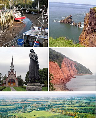
The Annapolis Valley is a valley and region in the province of Nova Scotia, Canada. It is located in the western part of the Nova Scotia peninsula, formed by a trough between two parallel mountain ranges along the shore of the Bay of Fundy. Statistics Canada defines the Annapolis Valley as an economic region, composed of Annapolis County, Kings County, and Hants County.
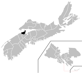
Kings County is a county in the Canadian province of Nova Scotia. With a population of 62,914 in the 2021 Census, Kings County is the third most populous county in the province. It is located in central Nova Scotia on the shore of the Bay of Fundy, with its northeastern part forming the western shore of the Minas Basin.

Kentville is an incorporated town in Nova Scotia. It is the most populous town in the Annapolis Valley. As of 2021, the town's population was 6,630. Its census agglomeration is 26,929.
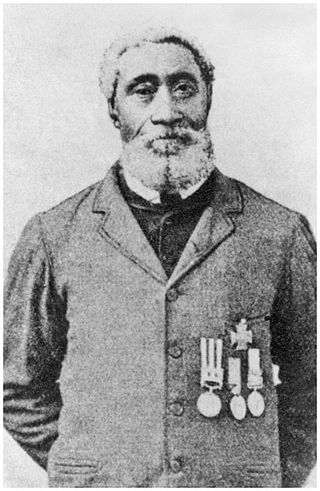
William Nelson Edward Hall was the first Black person, first Nova Scotian, and due to his actions in the 1857 Siege of Lucknow, he was the third Canadian to receive the Victoria Cross. He received the medal for his actions during the Indian Rebellion. During the action in which the naval gun crew with which he was serving came under heavy fire as they attacked a mosque. Hall and an officer from his ship continued to load and fire a 24-pounder gun at the walls of the Shah Nujeef mosque after the rest of the party had been killed or injured by the local resistance hoping to secure the restoration of Mughal suzerainty.
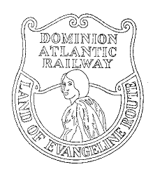
The Dominion Atlantic Railway was a historic railway which operated in the western part of Nova Scotia in Canada, primarily through an agricultural district known as the Annapolis Valley.

Castel di Sangro is a city and comune of 6,461 people in the Province of L'Aquila, in Abruzzo, central Italy. It is the main city of the Alto Sangro e Altopiano delle Cinque Miglia area.
New Minas is a village located in the eastern part of Kings County in Nova Scotia's Annapolis Valley. As of 2011, the population was 5,135.
Kings North is a provincial electoral district in Nova Scotia, Canada, that elects one member of the Nova Scotia House of Assembly.

The Maritime Junior Hockey League (MHL) is a Junior A ice hockey league under Hockey Canada, a part of the Canadian Junior Hockey League. It consists of six teams from New Brunswick, which make up the EastLink North Division, five teams from Nova Scotia, and one team from Prince Edward Island which make up the Eastlink South Division. The winner of the MHL playoffs competes for the Fred Page Cup against the winners of the Quebec Junior AAA Hockey League and the Central Junior A Hockey League. The winner of the Fred Page Cup then moves on to compete for the Canadian National Junior A Championship, formerly known as the Royal Bank Cup.

Trunk 1 is part of the Canadian province of Nova Scotia's system of Trunk Highways.

Trunk 12 is part of the Canadian province of Nova Scotia's system of Trunk Highways. The route runs from Chester Basin to Kentville, a distance of 66 kilometres (41 mi).

Route 207 is a collector road in the Canadian province of Nova Scotia. It is located in the Halifax Regional Municipality and connects Dartmouth to Porters Lake on the Eastern Shore.

Route 341 is a collector road in the Canadian province of Nova Scotia.

The Cornwallis River is in Kings County, Nova Scotia, Canada. It has a meander length of approximately 48 kilometres (30 mi) through eastern Kings County, from its source on the North Mountain at Grafton to its mouth near Wolfville on the Minas Basin. The lower portion of the river beginning at Kentville is tidal and there are extensive tidal marshes in the lower reaches. In its upper watershed at Berwick, the river draws on the Caribou Bog while a longer branch continues to the official source, a stream on the North Mountain at Grafton.

The Cornwallis Valley Railway (CVR) was a historic Canadian railway in Nova Scotia's Annapolis Valley. It was built in 1889 and ran 13.6 miles (21.9 km) from Kentville to Kingsport serving the Cornwallis Township area of Kings County. For most of its history, it operated as a branch line of the Dominion Atlantic Railway and was sometimes known as the "Kingsport Line".

The Windsor and Annapolis Railway (W&AR) was a historic Canadian railway that operated in Nova Scotia's Annapolis Valley.

Ship Harbour is a rural community located along the Eastern Shore of Nova Scotia, Canada, in the Halifax Regional Municipality. It is situated at the head of a natural harbour of the same name which opens into the Atlantic Ocean. The community is located along Trunk 7, approximately 80 kilometres (50 mi) east of Halifax, Nova Scotia and 45 kilometres (28 mi) west of Sheet Harbour, Nova Scotia. The area was settled in 1783 by a group of Loyalists from the Royal Nova Scotia Volunteer Regiment. The mi'kmaq referred to the area as Tedumunaboogwek, meaning "water-worn rock". The name of the community was derived from the name of the harbour, which in turn was derived from a rock at the entrance to the harbour, named Ship Rock, as it resembles a vessel from a distance. Ship Harbour is home to the Ship Harbour Mussel Farm, one of the largest mussel farm in North America. It is also home to Ralph's Downeast Diner, a small diner on Highway 7. It was previously Family Fries. There is also a community hall that hosts meeting for the Lake Charlotte region. West Ship Harbour Road collides with Nova Scotia Trunk 7 in Ship Harbour, which connects Ship Harbour with Owls Head, Little Harbour, Clam Harbour, Clam Harbour Beach Provincial Park and Lake Charlotte. Some minor roads include: Head Ship Harbour Loop Road, River Road, Bruce Drive, Newcombes Lane, Eisan Point Road and Goose Lane.

Leslie Raymond Fairn was a Canadian architect whose career is notable for its longevity and for the range of styles it encompassed, including Beaux Arts and Modernism. Most of his work was completed in the Maritimes.
