
St. Margarets Bay is a bay located on the Atlantic coast of Nova Scotia, Canada on the border of Halifax County and Lunenburg County.
The Aspotogan Peninsula is a peninsula in the eastern part of Lunenburg County, Nova Scotia, separating St. Margarets Bay in the east from Mahone Bay in the west. The peninsula was originally settled by second generation French immigrants on the east side and by second generation German immigrants on the west side. Traditionally fishing was a major industry for communities throughout the peninsula, however other primary industries such as farming and forestry were historically important as well. Shipping and shipbuilding were secondary and tertiary industries that also came into prominence during the 19th and early 20th centuries.
Highway 104 in Nova Scotia, Canada, runs from Fort Lawrence at the New Brunswick border near Amherst to River Tillard near St. Peter's. Except for the portion on Cape Breton Island between Port Hawkesbury and St. Peter's, it forms the main route of the Trans-Canada Highway across the province.

Nova Scotia Trunk 3 is an east-west trunk highway in Nova Scotia. The route runs from Halifax to Yarmouth, along the South Shore. Trunk 3's status as an important regional highway link has been superseded by the parallel Highway 103.
The Marine Drive is a designated scenic route along Nova Scotia's Eastern Shore. It closely follows the coast of the Atlantic Ocean and the Strait of Canso from the Canso Causeway to the junction of Route 322 and Highway 111 in Dartmouth.

Route 333 is a collector road in the Canadian province of Nova Scotia.
The Lighthouse Route is a scenic roadway in the Canadian province of Nova Scotia. It follows the province's South Shore for 585 km (364 mi) from Halifax to Yarmouth.
Route 245 is a collector road in the Canadian province of Nova Scotia. Route 245 is part of the Sunrise Trail.
Route 344 is a collector road in the Canadian province of Nova Scotia.

Route 332 is a collector road in the Canadian province of Nova Scotia. It is located in Lunenburg County, connecting Bridgewater at Trunk 3 with Lunenburg at Trunk 3. It is commonly referred to residences as Riverport Road as the village appears on all major road signage in the county.
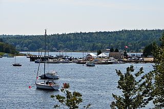
Hubbards is an unincorporated Canadian rural community on the South Shore of Nova Scotia.

The Municipality of the District of Chester is a Nova Scotia district municipality occupying the northeastern half of Lunenburg County, Canada.
Canadian Forces Station Mill Cove is a former Canadian Forces Station and currently a naval radio station located near Hubbards, Nova Scotia. Built in 1967, it is remotely operated by the Canadian Forces from CFB Halifax.
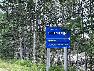
Queensland is a community of the Halifax Regional Municipality in the Canadian province of Nova Scotia.
Indian Harbour is a small fishing community of the Halifax Regional Municipality in the Canadian province of Nova Scotia on the Chebucto Peninsula. It is located between the communities of Peggy's Cove and Hackett's Cove.

Bayswater is a community in the Canadian province of Nova Scotia, located in the Chester Municipal District on the Aspotogan Peninsula in Lunenburg County on the Lighthouse Route. The community is home to Bayswater Beach Provincial park, Swissair 111 memorial, and All Saints Anglican Church
Blandford is a community in the Canadian province of Nova Scotia, located in the Chester Municipal District on the Aspotogan Peninsula on the Lighthouse Route. Blandford originally included the present day communities of New Harbour, Upper Blandford, and Deep Cove.
East River is a community in the Canadian province of Nova Scotia, located in the Chester Municipal District on the Aspotogan Peninsula on the Lighthouse Route at the junction of and Trunk 3.