Hammonds Plains is a suburban area of the Halifax Regional Municipality in Nova Scotia, Canada, located 20 km northwest of Downtown Halifax.

Lower Sackville is a suburban community of the Halifax Regional Municipality, Nova Scotia, Canada.
Highway 103 is an east-west highway in Nova Scotia that runs from Halifax to Yarmouth.
Highway 101 is an east-west highway in Nova Scotia that runs from Bedford to Yarmouth.
Highway 102 is a north–south highway in the Canadian province of Nova Scotia that runs from Halifax to Onslow, immediately north of the town of Truro. It is the busiest highway in Atlantic Canada.

Highway 107 in Nova Scotia runs through the eastern suburbs of the Halifax Regional Municipality, from the Bedford, Nova Scotia-Lower Sackville Border Line off Nova Scotia Highway 107 an intersection with Trunk 7 in Musquodoboit Harbour. It is 52.1 km (32.4 mi) long, and is mostly two lane, controlled access highway.

Highway 125 is a 28 km long controlled-access highway located in Nova Scotia's Cape Breton Regional Municipality. The provincial government named it Peacekeepers Way on August 18, 2008. Part of the provincial 100-series arterial highway network, Highway 125 encircles the west side of Sydney Harbour, from an interchange with Highway 105 at Sydney Mines to Trunk 4 immediately east of Sydney.
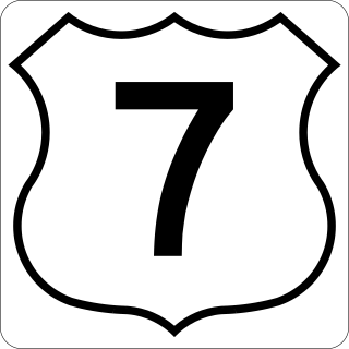
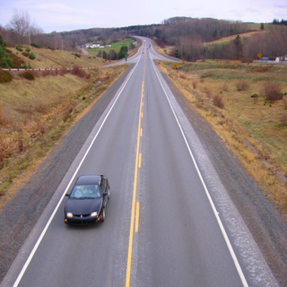
Nova Scotia Trunk 7 is part of the Canadian province of Nova Scotia's system of Trunk Highways. The route runs from Bedford to Antigonish, along the Eastern Shore for a distance of 269 kilometres (167 mi). Part of Trunk 7 is known as the Marine Drive.

Trunk 1 is part of the Canadian province of Nova Scotia's system of Trunk Highways.

Trunk 2 is part of the Canadian province of Nova Scotia's system of Trunk Highways. The route runs from Halifax to Fort Lawrence on the New Brunswick border. Until the 1960s, Trunk 2 was the Halifax area's most important highway link to other provinces, and was part of a longer Interprovincial Highway 2 which ended in Windsor, Ontario. The controlled access Highway 102 and Highway 104 now carry most arterial traffic in the area, while Trunk 2 serves regional and local traffic.

Nova Scotia Trunk 3 is an east-west trunk highway in Nova Scotia. The route runs from Halifax to Yarmouth, along the South Shore. Trunk 3's status as an important regional highway link has been superseded by the parallel Highway 103.
The Bedford Bypass, internally designated as Trunk 33, is a highway in the Canadian province of Nova Scotia.

Route 333 is a collector road in the Canadian province of Nova Scotia.
Route 224 is a collector road in the Canadian province of Nova Scotia. It is located in the Halifax Regional Municipality and Colchester County, connecting Sheet Harbour at Trunk 7 with Milford Station at Exit 9 of Highway 102 and Trunk 14. The route passes through the upper half of the Musquodoboit Valley.
Route 204 is a collector road in the Canadian province of Nova Scotia.
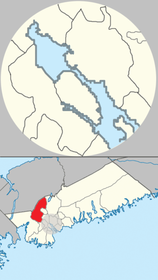
Upper Tantallon is a suburban community that extends from the Hammonds Plains Road to the crossroads of Trunk 3 and Route 333 within the Halifax Regional Municipality of Nova Scotia Canada, 28.5 km (17.7 mi) west from Downtown Halifax, Nova Scotia, Canada. The community is likely named for Tantallon Castle in Scotland.
Hammonds Plains, Upper Sackville and Beaver Bank is a planning area in the Halifax Regional Municipality, Nova Scotia. The area wraps from Exit 5 on Highway 103 to the west of the urban core of Halifax, and runs north and east, wrapping clockwise around the harbour along the Hammonds Plains Road, Lucasville Road and Sackville Drive, through Upper Sackville to Beaverbank.
The Old Annapolis Road was a planned direct route between Halifax and Annapolis Royal, the current and former capitals of Nova Scotia, in Eastern Canada. Work began in 1784 and was resumed in 1816 as a military settlement plan for Napoleonic War veterans. Known various times as the Annapolis Military Road, the Dalhousie Road and the Kempt Road, it led to some successful settlements but was never completed and was abandoned in 1829. Some disconnected sections remain in use today.
Upper Hammonds Plains is a Canadian suburban community located in Nova Scotia's Halifax Regional Municipality.