Bedford Highway

Last updated

Nova Scotia 1.svg

Nova Scotia 2.svg

Bedford Highway

Route information
Maintained by Halifax Regional Municipality
Transportation & Public Works
Length13.1 km [1]  (8.1 mi)
Component
highways
Nova Scotia 1.svgNova Scotia 2.svg Trunk 1  / Trunk 2
Major junctions
South endNova Scotia 111.svg Hwy 111  / Windsor Street
Major intersectionsNova Scotia 7.svg Trunk 7 (Dartmouth Road)
Nova Scotia 2.svg Trunk 2 (Hammonds Plains Road)
North endNova Scotia 101.svgNova Scotia 102.svg Hwy 101  / Hwy 102
Location
Country Canada
Province Nova Scotia
Highway system

The Bedford Highway is a highway in the Halifax Regional Municipality, Nova Scotia that is part of Trunk 2. It runs around the western side of the Bedford Basin. The highway starts at the Windsor Street intersection on the Halifax Peninsula and passes by the communities of Fairview, Rockingham, and Bedford, where it becomes part of Trunk 1 to Highway 101 .

Contents

Historically the Bedford Highway was part of the route from Halifax to Windsor, but also formed the first stage of a journey to Truro, with Sackville's Twelve Mile House staging inn marking the start of the Truro road. [2] The never-completed Annapolis Road also began on the Bedford Highway, at today's intersection with Kearney Lake Road, which is believed to partly follow the alignment of the early road. [3]

History

In 1958, the original Section of Highway 1 was blocked and knocked off due to the opening of Nova Scotia Highway 102 from Range Park to Memory Lane from Bedford, Nova Scotia to Sackville, Nova Scotia.

In 1970, Halifax ended their original terminus of Nova Scotia Highway 1 via Barrington Street, Quinpool Road, Robie Street, Spring Garden Road, Joseph Howe and Bayers Road to Main Road (renamed Bedford Highway in 1977) following the opening of The MacKay Bridge. The Concurrent Highway in Halifax ended Days Before the open of the new bridge.

In 1977, the whole main road was renamed Bedford Highway.

Notable places

The Chickenburger located at 1531 Bedford Highway (September 2018). The Chickenburger in 2018 (47342131212).jpg
The Chickenburger located at 1531 Bedford Highway (September 2018).

Major intersections

The entire route is located in Halifax Regional Municipality. 

Locationkm [1] miExitDestinationsNotes
Halifax 0.00.0Lady Hammond Road
Nova Scotia 111.svgNova Scotia 2.svg Hwy 111 east / Windsor Street (Trunk 2 south) MacKay Bridge, Dartmouth
Windsor Street Exchange; south end of Trunk 2 concurrency; continues as Lady Hammond Road
0.50.31Nova Scotia 3.svgNova Scotia 102.svg To Trunk 3  / Hwy 102  / Joseph Howe DriveInterchange
1.30.81Bayview Road
2.61.6Flamingo Drive
4.02.5Kearney Lake Road
5.93.7Larry Uteck Boulevard
Bedford 7.64.7Southgate Drive
8.35.2Nova Scotia Route 213.svg Hammonds Plains Road (Route 213 west)
9.76.0Meadowbrook Drive
10.56.5Union Street
11.06.8Nova Scotia 7.svg Dartmouth Road (Trunk 7 east) Dartmouth
11.27.0Nova Scotia 2.svg Trunk 2 north (Rocky Lake Drive) Waverley Nova Scotia 1.svg Trunk 1 eastern terminus; north end of Trunk 2 concurrency; south end of Trunk 1 concurrency
Lower Sackville 12.2–
13.1
7.6–
8.1
1G/HNova Scotia 102.svgOntario M502.svg Hwy 102  Airport, Truro, Halifax Signed as exits 1H (north) and 1G (south); exit 4A/B on Hwy 102
1KNova Scotia 1.svg Trunk 1 west (Cobequid Road) Lower Sackville Eastbound exit, westbound entrance; north end of Trunk 1 concurrency
Nova Scotia 101.svg Hwy 101 west Windsor, Annapolis Valley Continues as Hwy 101
1.000 mi = 1.609 km; 1.000 km = 0.621 mi

Related Research Articles

<span class="mw-page-title-main">Bedford, Nova Scotia</span> District of Halifax, Nova Scotia, Canada

Bedford is a former town and now a district of Halifax, Nova Scotia, Canada. It is situated on the north west shore of the Bedford Basin in the central area of the municipality. It borders the neighbouring communities of Hammonds Plains to the west, Sackville to the north, Dartmouth to the east, and Main Land Halifax to the south. Bedford was named in honour of John Russell, 4th Duke of Bedford, Secretary of State for the colonies in 1749.

<span class="mw-page-title-main">Lower Sackville, Nova Scotia</span> Community in Nova Scotia, Canada

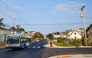
Lower Sackville is a suburban community of the Halifax Regional Municipality, Nova Scotia, Canada.

Middle Sackville is a suburban community located in Halifax Regional Municipality in Nova Scotia, Canada. It was named after George Germain, 1st Viscount Sackville.

<span class="mw-page-title-main">Nova Scotia Highway 111</span> Highway in Nova Scotia

Highway 111 is a 13-kilometre (8 mi) controlled-access highway in Halifax Regional Municipality, Nova Scotia, Canada.

<span class="mw-page-title-main">Nova Scotia Highway 101</span> Highway in Nova Scotia

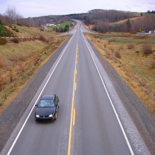
Highway 101 is an east-west highway in Nova Scotia that runs from Bedford to Yarmouth.

Highway 102 is a north–south highway in the Canadian province of Nova Scotia that runs from Halifax to Onslow, immediately north of the town of Truro. It is the busiest highway in Atlantic Canada.

<span class="mw-page-title-main">Nova Scotia Highway 107</span> Highway in Nova Scotia

Highway 107 in Nova Scotia runs through the eastern suburbs of the Halifax Regional Municipality, from the Burnside Industrial Park in Dartmouth to an intersection with Trunk 7 in Musquodoboit Harbour. It is 43.2 km (26.8 mi) long, and is mostly two lane, controlled access highway.

<span class="mw-page-title-main">Clayton Park, Nova Scotia</span> Community in Nova Scotia, Canada

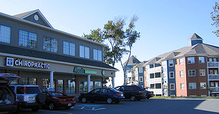
Clayton Park is a community within Halifax, Nova Scotia, Canada.

<span class="mw-page-title-main">Downtown Halifax</span> Downtown Area in Nova Scotia, Canada

Downtown Halifax is the primary central business district of the Municipality of Halifax. Located on the central-eastern portion of the Halifax Peninsula, on Halifax Harbour. Along with Downtown Dartmouth, and other de facto central business districts within the Municipality, Downtown Halifax serves as the business, entertainment, and tourism hub of the region.

Rockingham is a community located within the urban area of the Municipality of Halifax, in Nova Scotia, Canada.

<span class="mw-page-title-main">Nova Scotia Trunk 1</span> Highway in Nova Scotia

Trunk 1 is part of the Canadian province of Nova Scotia's system of Trunk Highways.

<span class="mw-page-title-main">Nova Scotia Trunk 2</span> Highway in Nova Scotia, Canada

Trunk 2 is part of the Canadian province of Nova Scotia's system of Trunk Highways. The route runs from Halifax to Fort Lawrence on the New Brunswick border. Until the 1960s, Trunk 2 was the Halifax area's most important highway link to other provinces, and was part of a longer Interprovincial Highway 2 which ended in Windsor, Ontario. The controlled access Highway 102 and Highway 104 now carry most arterial traffic in the area, while Trunk 2 serves regional and local traffic.

The Bedford Bypass, internally designated as Trunk 33, is a highway in the Canadian province of Nova Scotia.

<span class="mw-page-title-main">100-series highways (Nova Scotia)</span> Highway system in Nova Scotia

The 100-Series Highways are a series of arterial highways in the Canadian province of Nova Scotia.

<span class="mw-page-title-main">Fairview, Nova Scotia</span> Urban Community in Nova Scotia, Canada

Fairview is a community within the urban area of Halifax in Nova Scotia, Canada.

<span class="mw-page-title-main">Hammonds Plains, Upper Sackville and Beaverbank, Nova Scotia</span> Planning Area in Nova Scotia, Canada

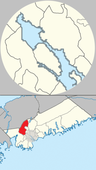
Hammonds Plains, Upper Sackville and Beaver Bank is a planning area in the Halifax Regional Municipality, Nova Scotia. The area wraps from Exit 5 on Highway 103 to the west of the urban core of Halifax, and runs north and east, wrapping clockwise around the harbour along the Hammonds Plains Road, Lucasville Road and Sackville Drive, through Upper Sackville to Beaverbank.

<span class="mw-page-title-main">Sackville River</span> River in Nova Scotia, Canada

The Sackville River is a river in Hants County and Halifax Regional Municipality, Nova Scotia, Canada. It empties into Bedford Basin. The Little Sackville River is a tributary.

Beechwood Park is a neighbourhood within the urban area of Municipality of Halifax, Nova Scotia, Canada.

Dunbrack Street is a 9.2 km (5.7 mi) arterial road in Mainland Halifax, Nova Scotia. It runs from Route 306 in Spryfield to Kearney Lake Road in Rockingham. Prior to 2019, Dunbrack Street ran from Kearney Lake Road in Rockingham to Main Avenue in Fairview. The remaining section was named Northwest Arm Drive. The former Northwest Arm section is assigned Trunk 32 by the provincial transportation department as an unsigned highway.

References

  1. 1 2 Google (January 28, 2020). "Bedford Highway" (Map). Google Maps . Google. Retrieved January 28, 2020.
  2. "A Brief History of Sackville". Fultz House Museum. Archived from the original on July 6, 2011. Retrieved December 29, 2010.
  3. Sanders, Mike; Beanlands, Sara (August 2009). "Highway 113 Archaeological Assessment" (PDF). Nova Scotia Transportation and Infrastructure Renewal. Retrieved December 29, 2010.
  4. "House of Intercessory Prayer Ministries" . Retrieved January 30, 2020.