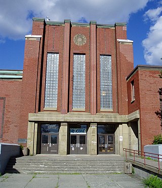
Queen Elizabeth High School (QEH) was a secondary school in Halifax, Nova Scotia. QEH was known for its high academic standards, competitive sports teams and distinguished extra-curricular activities such as its annual model parliament and musical productions. Its Reach for the Top team won the CBC-TV national championship in 1975.

The Quinpool District refers to a commercial district of Halifax, Nova Scotia, encompassing the eastern portion of Quinpool Road as well as the streets directly north and south of it. Prominent landmarks on Quinpool Road include the Atlantica Hotel, the Oxford Theatre, and an eclectic variety of local businesses, including many popular Chinese and Greek restaurants.
The Halifax Peninsula is a peninsula within the urban area of the Municipality of Halifax, Nova Scotia.

The Spring Garden Road area, along with Barrington Street is a major commercial and cultural district in Halifax, Nova Scotia, Canada. It acquired its name from the fresh water spring that flows directly beneath it. It comprises Spring Garden Road, South Park Street, and a number of smaller side streets. The area is considered to be one of the trendiest areas in Halifax and is the busiest shopping district east of Quebec.

The South End is a neighbourhood within Halifax's urban area, in the Municipality of Halifax, Nova Scotia, Canada.

The Halifax Common, in local popular usage often referred to as the Commons, is a Canadian urban park in Halifax, Nova Scotia. It is Canada’s oldest urban park.
The Halifax Regional Centre for Education is the public school district responsible for 136 elementary, junior high, and high schools located in the Halifax Regional Municipality. The current Regional Executive Director is Steve Gallagher. The district's office is on Spectacle Lake Drive in Dartmouth. The district's stated vision is "to provide a high quality education to every student every day". On January 24, 2018, the provincial government announced that the Halifax Regional School Board would be dissolved and that kindergarten to grade 12 education services in Halifax would administered by an appointed provincial council. The Halifa Regional School Board was dissolved on March 31, 2018.

Trunk 2 is part of the Canadian province of Nova Scotia's system of Trunk Highways. The route runs from Halifax to Fort Lawrence on the New Brunswick border. Until the 1960s, Trunk 2 was the Halifax area's most important highway link to other provinces, and was part of a longer Interprovincial Highway 2 which ended in Windsor, Ontario. The controlled access Highway 102 and Highway 104 now carry most arterial traffic in the area, while Trunk 2 serves regional and local traffic.

St. Paul's Church is an evangelical Anglican church in downtown Halifax, Nova Scotia, within the Diocese of Nova Scotia and Prince Edward Island of the Anglican Church of Canada. It is located at the south end of the Grand Parade, an open square in downtown Halifax with Halifax City Hall at the northern end.

Halifax Public Libraries (HPL) is a Canadian public library system serving residents of Halifax, Nova Scotia. It is the largest public library system in Nova Scotia, with over 2.8 million visits to library branches and 172,520 active registered borrowers or 44% of the municipality's population. With roots that trace back to the establishment of the Citizens' Free Library in 1864, the current library system was created in 1996 during municipal amalgamation, and now consists of 14 branches and a collection of almost 1 million items.

Barrington Street is a major street in Halifax, Nova Scotia, Canada, running from the MacKay Bridge in the North End approximately 7 km south, through Downtown Halifax to Inglis Street in the South End. Its civic numbers range from 950 to 4756 on the Halifax Peninsula street grid numbering system.
Inglis Street is a street on the Halifax Peninsula in the Halifax Regional Municipality Nova Scotia, Canada. It runs between Barrington Street and Beaufort Avenue. It forms the northern boundary of the campus of Saint Mary's University.
Camp Hill is a small hill on the Halifax Peninsula, Nova Scotia. Historically, much of the hill was part of the Halifax Common, and is today home to a number of public institutions. The topography of the area has been greatly altered over time, with the construction of large hospital and high school buildings. The Camp Hill area is roughly enclosed within two city blocks; the Camp Hill Cemetery, and the block bounded by Robie Street, Summer Street, Bell Road, and Veterans Memorial Lane.
Leiblin Park, Nova Scotia is a residential neighbourhood in Halifax on the Mainland Halifax within the Halifax Regional Municipality, Nova Scotia.
Dunbrack Street is a 9.2 km (5.7 mi) arterial road in Mainland Halifax, Nova Scotia. It runs from Route 306 in Spryfield to Kearney Lake Road in Rockingham. Prior to 2019, Dunbrack Street ran from Kearney Lake Road in Rockingham to Main Avenue in Fairview. The remaining section was named Northwest Arm Drive. The former Northwest Arm section is assigned Trunk 32 by the provincial transportation department as an unsigned highway.
The Nova Scotia Cotton Manufacturing Company was a cotton mill located in Halifax, Nova Scotia which was founded in 1882 and destroyed with great loss of life by the Halifax Explosion in 1917.

The Halifax Club is a private club in Halifax, Nova Scotia that was established in 1862. The club serves as a meeting place for business-minded men and women. It is a place where they can "meet, toast the day's successes, dine or simply relax in a warm atmosphere of history and tradition." The Club has a substantial art collection including a self-portrait of Benjamin West and a painting by Robert Field. The Club was built by George Lang.

Gorsebrook Park is a 19-acre Canadian urban park located in the South End of Halifax, Nova Scotia.

Cycling infrastructure in the Canadian city of Halifax, Nova Scotia includes most regular streets and roads, bike lanes, protected cycle tracks, local street bikeways, and multi-use pathways.
