Highway 102 is a north–south highway in the Canadian province of Nova Scotia that runs from Halifax to Onslow, immediately north of the town of Truro. It is the busiest highway in Atlantic Canada.

Highway 107 in Nova Scotia runs through the eastern suburbs of the Halifax Regional Municipality, from the Burnside Industrial Park in Dartmouth to an intersection with Trunk 7 in Musquodoboit Harbour. It is 43.2 km (26.8 mi) long, and is mostly two lane, controlled access highway.

The Eastern Shore is a region of the Canadian province of Nova Scotia. It is the Atlantic coast running northeast from Halifax Harbour to the eastern end of the peninsula at the Strait of Canso.

The Musquodoboit River is a Canadian river located in central Nova Scotia in the northeastern part of Halifax Regional Municipality. The river is approximately 97 kilometres (60 mi) in length with roughly 88 kilometres (55 mi) being traversable by paddle. It has a watershed area of 1,409 square kilometres (544 sq mi)
The Shubenacadie Valley is a Canadian rural region in central Nova Scotia.
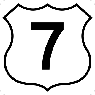
Nova Scotia Trunk 7 is part of the Canadian province of Nova Scotia's system of Trunk Highways. The route runs from Bedford to Antigonish, along the Eastern Shore for a distance of 269 kilometres (167 mi). Part of Trunk 7 is known as the Marine Drive.

Trunk 1 is part of the Canadian province of Nova Scotia's system of Trunk Highways.

Trunk 2 is part of the Canadian province of Nova Scotia's system of Trunk Highways. The route runs from Halifax to Fort Lawrence on the New Brunswick border. Until the 1960s, Trunk 2 was the Halifax area's most important highway link to other provinces, and was part of a longer Interprovincial Highway 2 which ended in Windsor, Ontario. The controlled access Highway 102 and Highway 104 now carry most arterial traffic in the area, while Trunk 2 serves regional and local traffic.
Route 374 is a collector road in the Canadian province of Nova Scotia. It connects New Glasgow at Exit 24 of Nova Scotia Highway 104 with Sheet Harbour at Trunk 7. The highway runs through the Halifax Regional Municipality, Guysborough County & Pictou County.
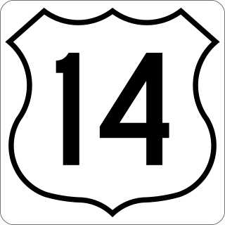
Trunk 14 is part of the Canadian province of Nova Scotia's system of Trunk Highways. The route runs from Chester to Milford Station through the Windsor area, for a distance of 121 kilometres (75 mi).
The Marine Drive is a designated scenic route along Nova Scotia's Eastern Shore. It closely follows the coast of the Atlantic Ocean and the Strait of Canso from the Canso Causeway to the junction of Route 322 and Highway 111 in Dartmouth.
The Glooscap Trail is a scenic roadway in the Canadian province of Nova Scotia.

Route 357 is a collector road in the Canadian province of Nova Scotia. It is located in the Halifax Regional Municipality and connects Musquodoboit Harbour at Trunk 7 with Middle Musquodoboit at Route 224.

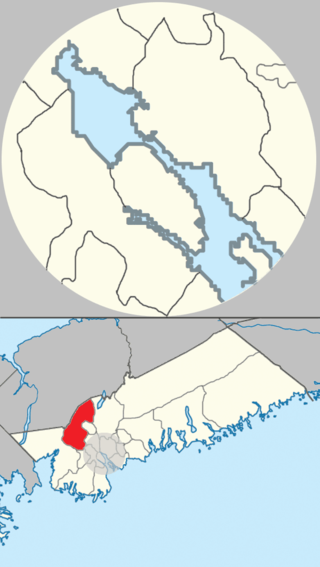
Middle Musquodoboit is a rural community in the Musquodoboit Valley region of Nova Scotia, Canada within the Halifax Regional Municipality, along the Musquodoboit River at the junction of Route 357 with Route 224, 78 kilometres (48 mi) from Dartmouth, Nova Scotia. The community's name comes from the First Nations' word Mooskoduboogwek, which means to suddenly widen out after a narrow entrance at a mouth. For a time after 1883, Middle Musquodoboit was called Laytonville, but at some point reverted to its former name.
Hammonds Plains, Upper Sackville and Beaver Bank is a planning area in the Halifax Regional Municipality, Nova Scotia. The area wraps from Exit 5 on Highway 103 to the west of the urban core of Halifax, and runs north and east, wrapping clockwise around the harbour along the Hammonds Plains Road, Lucasville Road and Sackville Drive, through Upper Sackville to Beaverbank.
Sheet Harbour Road is a community of the Halifax Regional Municipality in the Canadian province of Nova Scotia. It is located just five minutes south of Upper Musquodoboit, Nova Scotia. Its name is derived from Route 224, which is the primary route from the Musquodoboit Valley to Sheet Harbour, Nova Scotia.
Beaver Lake 17 is a small Mi'kmaq reserve on the Eastern Shore of Nova Scotia, Canada, in the Halifax Regional Municipality. It is located on Route 224 about 21 km (13 mi) northwest of Sheet Harbour and about 20 km (12 mi) southeast of Upper Musquodoboit. The community is located adjacent to Lower Beaver Lake and is located within the community of Beaver Dam.
