Musquodoboit Valley

Last updated • 4 min readFrom Wikipedia, The Free Encyclopedia
Musquodoboit Valley
Valley
Greenwood NS.JPG
Musquodoboit Valley at Greenwood
Novascotiahrm-musqvalleydutchsettlement.png
Map of Musquodoboit Valley/Dutch Settlement planning area in Halifax, Nova Scotia
Canada Nova Scotia location map 2.svg
Red pog.svg
Musquodoboit Valley
Location within Nova Scotia
Coordinates: 45°02′35″N63°09′06″W / 45.04306°N 63.15167°W / 45.04306; -63.15167 Coordinates: 45°02′35″N63°09′06″W / 45.04306°N 63.15167°W / 45.04306; -63.15167
CountryFlag of Canada (Pantone).svg  Canada
ProvinceFlag of Nova Scotia.svg  Nova Scotia
Municipality Halifax Regional Municipality
Area
[1]
  Total714 km2 (276 sq mi)
Time zone UTC-4 (AST)
  Summer (DST) UTC-3 (ADT)
Communities Caribou Mines, Chaplin, Dean, Pleasant Valley, Sheet Harbour Road, Upper Musquodoboit, Fraser Settlement, Kent, Centre Musquodoboit, Reid, Newcomb Corner, Lindsay Lake, Elmsvale, Higginsville, Brookvale, Glenmore, Middle Musquodoboit, South Section, Murchyville, Mooseland, Chaswood, Cooks Brook, Carrolls Corner, Elderbank, Lake Egmont, Meaghers Grant, Meagher, Lower Meaghers Grant, Musquodoboit Harbour, Greenwood
HighwaysNova Scotia Route 212.svg Route 212
Nova Scotia Route 224.svg Route 224
Nova Scotia Route 336.svg Route 336
Nova Scotia Route 357.svg Route 357
Website www.musquodoboitvalley.ca

The Musquodoboit Valley ( /ˌmʌskəˈdɒbɪt/ MUS-kə-DOB-it) is a valley and region in the Halifax Regional Municipality of Nova Scotia, Canada. It is administratively located in the municipality's Musquodoboit Valley & Dutch Settlement planning area and the western edge of the valley includes communities that are considered part of the commutershed for the urban area of the Halifax Regional Municipality. The picturesque Musquodoboit River flows through majority of the valley, passing by most of the communities in the valley. The river is approximately 97 kilometres (60 mi) long and originates in the extreme northeastern area of the valley. The three largest communities in the valley are Upper Musquodoboit, Middle Musquodoboit and Musquodoboit Harbour. The word "Musquodoboit" is derived from the Mi’kmaq language and means "rolling out in foam". [1]

Contents

Geography

Musquodoboit River MusquodoboitRiver 2010.jpg
Musquodoboit River

The Musquodoboit Valley region is located within the northeastern reaches of the Halifax Regional Municipality. Entirely rural, [2] the region shares more in common economically with the neighboring rural areas of adjacent Pictou and Colchester counties, as well as the nearby Eastern Shore region, as the economy of the valley relies on forestry and agriculture. [3] The Musquodoboit River bisects the valley, the headwaters of which are at the confluence of the North and South branches of the Musquodoboit River. [4] [5] [6] The drainage area of the river is 1,316 square kilometres (508 sq mi). [7] The mouth of the river is at Musquodoboit Harbour, which in turn flows into the Atlantic Ocean. [4] [8]

History

The name of the valley, as well as the name of several communities within it, is derived from the mi'kmaw word Mooskudoboogwek, meaning "suddenly widening out after a narrow entrance at its mouth". [9] Musquodoboit is an Anglicized version of the native name. The area of present-day Musquodoboit Harbour was first settled by Europeans in the 1680s by the French. Claude Pettpipas, Jr. and his Mi'kmaq wife, Marie Therese, moved from Port Royal and the Annapolis Valley and raised their family near Martinique Beach, at the mouth of the river. The first land grants around Middle Musquodoboit were given in the 1780s, and the Mi'kmaw referred to the place as Natkamkik, meaning "the river extends uphill". The area was known as Laytonville until sometime after 1883. [10] Gold mining was prevalent in the region in the 20th century, most notably in the community of Moose River Gold Mines. The community was the site of a cave-in disaster in 1936 which received national attention. [1] [11]

Economy

Middle Musquodoboit Middle Musquodoboit NS.JPG
Middle Musquodoboit
Upper Musquodoboit Upper Musquodoboit NS.JPG
Upper Musquodoboit

The upper part of the Musquodoboit Valley comprises the largest farming district in the Halifax Regional Municipality. The farms have adapted over time from family-run farms to large commercial scale farms, to adapt to the changing market. [3] Most of the non-farming businesses within the valley are concentrated in Upper Musquodoboit and Middle Musquodoboit.

Middle Musquodoboit had a Co-op store, which recently closed, as well as a bakery and restaurant. [12] A fire station is present within the community, as well as a detachment of the Royal Canadian Mounted Police. [13] [14] The Natural Resources Education Centre is located within the community as well, offering cuuriculum-based programs as well as three kilometres (1.9 mi) of hiking trails. [15] A federal post office and branch of the Royal Bank of Canada are in the community as well. [16] [17] Middle Musquodoboit also hosts the annual Halifax County Exhibition. [1] Upper Musquodoboit has a convenience store, a volunteer fire station, an auto-body shop and a limestone mine. [18] [13] [19] [20]

Musquodoboit Valley Memorial Hospital is the only hospital in the Musquodoboit Valley. It is located in Middle Musquodoboit and is on the opposite side of the river to the downtown area. It is adjacent to Braeside Nursing Home. [21] [22]

Education

Three schools are present within the valley region.

Musquodoboit Rural High School (MRHS) is the only high school in the Musquodoboit Valley. It has Three feeder schools and teaches grades 7-12. Offering an Intensive French program, the building was constructed in 2008. In 2018, there were 270 students enrolled in the school. [23] Musquodoboit Valley Education Centre (MVEC) is a feeder school of MRHS. Located in Middle Musquodoboit, the school teaches grades primary through six. The school was constructed in 2001 and had an enrollment of 113 in 2018. [24]

Upper Musquodoboit Consolidated Elementary School is located in Upper Musquodoboit. The school is a feeder school of MRHS. Serving grades primary through six, the school was constructed in 1962. In 2018, there were thirty students enrolled in the school. [25]

Climate

Climate data for Middle Musquodoboit, 1981–2010 normals, extremes 1961–present
MonthJanFebMarAprMayJunJulAugSepOctNovDecYear
Record high °C (°F)16.5
(61.7)
17.0
(62.6)
28.0
(82.4)
30.5
(86.9)
33.3
(91.9)
33.9
(93.0)
34.5
(94.1)
35.6
(96.1)
33.0
(91.4)
26.7
(80.1)
23.5
(74.3)
16.0
(60.8)
35.6
(96.1)
Average high °C (°F)−0.9
(30.4)
0.2
(32.4)
3.9
(39.0)
9.6
(49.3)
16.1
(61.0)
21.3
(70.3)
24.7
(76.5)
24.6
(76.3)
20.3
(68.5)
14.0
(57.2)
7.8
(46.0)
2.2
(36.0)
12.0
(53.6)
Daily mean °C (°F)−6.2
(20.8)
−5.2
(22.6)
−1.3
(29.7)
4.4
(39.9)
9.9
(49.8)
14.8
(58.6)
18.5
(65.3)
18.4
(65.1)
14.2
(57.6)
8.5
(47.3)
3.5
(38.3)
−2.4
(27.7)
6.4
(43.5)
Average low °C (°F)−11.4
(11.5)
−10.6
(12.9)
−6.4
(20.5)
−0.9
(30.4)
3.7
(38.7)
8.3
(46.9)
12.2
(54.0)
12.2
(54.0)
7.9
(46.2)
2.9
(37.2)
−1.0
(30.2)
−7.1
(19.2)
0.8
(33.4)
Record low °C (°F)−34.0
(−29.2)
−33.0
(−27.4)
−31.0
(−23.8)
−15.0
(5.0)
−7.8
(18.0)
−3.0
(26.6)
1.1
(34.0)
−1.5
(29.3)
−4.5
(23.9)
−10.6
(12.9)
−21.0
(−5.8)
−34.0
(−29.2)
−34.0
(−29.2)
Average precipitation mm (inches)129.8
(5.11)
100.5
(3.96)
124.2
(4.89)
109.0
(4.29)
105.4
(4.15)
99.8
(3.93)
103.8
(4.09)
91.9
(3.62)
110.7
(4.36)
116.7
(4.59)
136.8
(5.39)
129.1
(5.08)
1,357.6
(53.45)
Average rainfall mm (inches)80.4
(3.17)
62.1
(2.44)
92.8
(3.65)
99.5
(3.92)
104.9
(4.13)
99.8
(3.93)
103.8
(4.09)
91.9
(3.62)
110.7
(4.36)
116.7
(4.59)
128.6
(5.06)
97.2
(3.83)
1,188.3
(46.78)
Average snowfall cm (inches)49.4
(19.4)
41.3
(16.3)
31.4
(12.4)
9.5
(3.7)
0.5
(0.2)
0.0
(0.0)
0.0
(0.0)
0.0
(0.0)
0.0
(0.0)
0.0
(0.0)
8.2
(3.2)
31.9
(12.6)
172.2
(67.8)
Average precipitation days (≥ 0.2 mm)14.812.113.715.014.914.012.712.712.314.715.814.5167.1
Average rainy days (≥ 0.2 mm)7.56.09.414.014.814.012.712.712.314.714.810.1143.1
Average snowy days (≥ 0.2 cm)9.07.55.41.80.080.00.00.00.00.01.96.231.8
Source: Environment Canada [26] [27] [28] [29]

Related Research Articles

<span class="mw-page-title-main">Sackville—Preston—Chezzetcook</span> Federal electoral district in Nova Scotia, Canada

Sackville—Preston—Chezzetcook is a federal electoral district in Halifax, Nova Scotia, Canada, that has been represented in the House of Commons of Canada since 1997.

<span class="mw-page-title-main">Halifax, Nova Scotia</span> Capital and most populous municipality of Nova Scotia, Canada

Halifax is the capital and largest municipality of the Canadian province of Nova Scotia, and the largest municipality in Atlantic Canada. Halifax is one of Canada's fastest growing municipalities, and as of 2022, it is estimated that the CMA population of Halifax was 480,582, with 348,634 people in its urban area. The regional municipality consists of four former municipalities that were amalgamated in 1996: Halifax, Dartmouth, Bedford, and Halifax County.

<span class="mw-page-title-main">Cole Harbour, Nova Scotia</span> Community in Nova Scotia, Canada

Cole Harbour is a former village and current community located in Nova Scotia, Canada that is part of the Halifax Regional Municipality.

<span class="mw-page-title-main">Eastern Shore (Nova Scotia)</span> Region of Nova Scotia

The Eastern Shore is a region of the Canadian province of Nova Scotia. It is the Atlantic coast running northeast from Halifax Harbour to the eastern end of the peninsula at the Strait of Canso.

The Halifax Regional Municipality (HRM) in Nova Scotia, Canada has a widely varied geography.

<span class="mw-page-title-main">Musquodoboit River</span> River in Nova Scotia, Canada

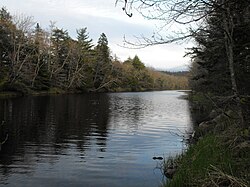
The Musquodoboit River is a Canadian river located in central Nova Scotia in the northeastern part of Halifax Regional Municipality. The river is approximately 97 kilometres (60 mi) in length with roughly 88 kilometres (55 mi) being traversable by paddle. It has a watershed area of 1,409 square kilometres (544 sq mi)

Area codes 902 and 782 are telephone area codes in the North American Numbering Plan (NANP) for the Canadian provinces of Nova Scotia and Prince Edward Island. Area code 902 was one of the original North American area codes established in October 1947.

<span class="mw-page-title-main">Sheet Harbour, Nova Scotia</span> Place in Nova Scotia, Canada

Sheet Harbour is a rural community in Nova Scotia, Canada. It is located in the eastern reaches of the Halifax Regional Municipality, approximately 117 km (73 mi) northeast of the central urban area of the municipality, concentrated on Downtown Halifax and Dartmouth. The community is located along the Marine Drive scenic route on Trunk 7 at its junctions with Route 224 and Route 374. Surrounding the branched harbour which its name is derived from, the community has a population of about 800 and its respective census tract, containing sizable amounts of land around the community, has a population of 3,478 as of the 2011 Census. Two rivers, West River and East River, flow through the community and into the Northwest and Northeast Arms of the harbour respectively. The coastline of the community is heavily eroded and the region in which the community is located has an abundance of lakes. The region has a humid continental climate, congruent with the majority of Nova Scotia, and the ocean significantly influences the temperature.

<span class="mw-page-title-main">Nova Scotia Route 224</span>

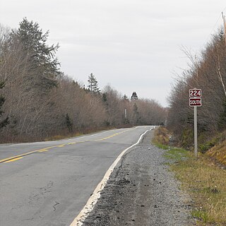
Route 224 is a collector road in the Canadian province of Nova Scotia. It is located in the Halifax Regional Municipality and Colchester County, connecting Sheet Harbour at Trunk 7 with Milford Station at Exit 9 of Highway 102 and Trunk 14. The route passes through the upper half of the Musquodoboit Valley.

<span class="mw-page-title-main">Middle Musquodoboit, Nova Scotia</span> Place in Nova Scotia, Canada

Middle Musquodoboit is a rural community in the Musquodoboit Valley region of Nova Scotia, Canada within the Halifax Regional Municipality, along the Musquodoboit River at the junction of Route 357 with Route 224, 78 kilometres (48 mi) from Dartmouth, Nova Scotia. The community's name comes from the First Nations' word Mooskoduboogwek, which means to suddenly widen out after a narrow entrance at a mouth. For a time after 1883, Middle Musquodoboit was called Laytonville, but at some point reverted to its former name.

<span class="mw-page-title-main">Upper Musquodoboit, Nova Scotia</span> Place in Nova Scotia, Canada

Upper Musquodoboit is a forestry and farming community in the northeastern reaches of the Musquodoboit Valley, Nova Scotia, Canada within the Halifax Regional Municipality, 75 kilometres (47 mi) from Downtown Halifax. The community is located along the Musquodoboit River. The community had a population of 473 at the 2006 Census and the community has an area of 380.25 square kilometres (146.82 sq mi). Upper Musquodoboit is situated at the junction of Route 336 with Route 224.

<span class="mw-page-title-main">Moser River, Nova Scotia</span> Place in Nova Scotia, Canada

Moser River is a rural community on the Eastern Shore of Nova Scotia, Canada, in the Halifax Regional Municipality. The community lies along the Marine Drive on Trunk 7, 32 km (20 mi) east of Sheet Harbour and 51 km (32 mi) southwest of Sherbrooke. The community is located along the shores of Necum Teuch Harbour, an inlet of the Atlantic Ocean, and is at the mouth of Moser River. The area was called Noogoomkeak in the mi'kmaq language, translating to "soft sand place". The community is named for Henry Moser, who was the son of Jacob Moser, who settled the area in the early 1800s. The first school in the community was built in 1905, and another school, Moser River Consolidated School, was built in 1957. The school closed in 2015, due to its very low student population. Marine Drive Academy in Sheet Harbour serves the community and its surroundings at all grade levels. There is a small seaside park in the community near the former school, as well as a post office and convenience store.

<span class="mw-page-title-main">Musquodoboit Harbour, Nova Scotia</span> Place in Nova Scotia, Canada

Musquodoboit Harbour is a rural community located in Nova Scotia, Canada within the Halifax Regional Municipality. The community is situated on the Eastern Shore at the mouth of the Musquodoboit River. The community lies 45 kilometres east of downtown Halifax. With a hospital, RCMP detachment, postal outlet, schools, recreational center, library, municipal office and other services, Musquodoboit Harbour is a serve centre for many of the surrounding communities.

<span class="mw-page-title-main">Transportation in Halifax, Nova Scotia</span>

Transport in Halifax, Nova Scotia consists of a variety of modes.

The Halifax Regional Municipality (HRM) is a major generator of economic activity in Atlantic Canada.

The Capital District Health Authority was the largest of the nine health authorities in the Canadian province of Nova Scotia. In 2015 it was merged into the new, province-wide Nova Scotia Health Authority.

Beaver Dam is a rural community on the Eastern Shore of Nova Scotia, Canada, in the Halifax Regional Municipality. It is located along Route 224, about 21 km (13 mi) northwest of Sheet Harbour and about 19 km (12 mi) southeast of Upper Musquodoboit. Beaver Lake 17, a small Mi'kmaq reserve, is located in the community as well. The community is located adjacent to Lower Beaver Lake.

Beaver Lake 17 is a small Mi'kmaq reserve on the Eastern Shore of Nova Scotia, Canada, in the Halifax Regional Municipality. It is located on Route 224 about 21 km (13 mi) northwest of Sheet Harbour and about 20 km (12 mi) southeast of Upper Musquodoboit. The community is located adjacent to Lower Beaver Lake and is located within the community of Beaver Dam.

<span class="mw-page-title-main">Outline of Nova Scotia</span> Overview of and topical guide to Nova Scotia

The following outline is provided as an overview of and topical guide to Nova Scotia:

<span class="mw-page-title-main">West River Sheet Harbour</span> River in Nova Scotia, Canada

West River Sheet Harbour is a river on the Eastern Shore of Nova Scotia, Canada, in the Halifax Regional Municipality. Its headwaters are near the Musquodoboit Valley and the river flows southeast and empties in to the Northwest Arm of Sheet Harbour, Nova Scotia. The river has three main tributaries: West River Main, Killag River and Little River. The river was suffering from acidification, so a lime doser was installed and has been in use since September 2005. It stabilized the river's pH at 5.5, a healthy level for aquatic life.

References

Notes

  1. 1 2 3 4 "Experience Musquodoboit Valley!". TownCryer News. Retrieved 23 October 2015.
  2. "Settlement Areas". Halifax Regional Municipality. Archived from the original on June 14, 2007. Retrieved April 30, 2015.
  3. 1 2 "Agriculture & Industry". TownCryer News. Archived from the original on 2016-01-08. Retrieved 23 October 2015.
  4. 1 2 "Musqudoboit River". Natural Resources Canada . Retrieved 12 May 2019.
  5. "South Branch Musquodoboit River". Natural Resources Canada . Retrieved 12 May 2019.
  6. "North Branch Musquodoboit River". Natural Resources Canada . Retrieved 12 May 2019.
  7. "T8.1 Freshwater Hydrology" (PDF). Nova Scotia Museum of Natural History. Archived from the original (PDF) on 7 June 2003. Retrieved 11 May 2019.
  8. "Musqudoboit Harbour". Natural Resources Canada . Retrieved 12 May 2019.
  9. Scott 2011, p. 174.
  10. Scott 2011, p. 162.
  11. "Disaster at Moose River Gold Mine". Art Gallery of Nova Scotia. Retrieved 11 May 2019.
  12. "Community Directory". TownCryer News. Archived from the original on 7 October 2015. Retrieved 23 October 2015.
  13. 1 2 "Fire Stations". Halifax Regional Municipality. Archived from the original on 2015-10-08. Retrieved 23 October 2015.
  14. "About Halifax District RCMP". Royal Canadian Mounted Police. Retrieved 23 October 2015.
  15. "NREC - Our Facilities". Nova Scotia Government. Retrieved 23 October 2015.
  16. "CanadaPost - Post Office: MIDDLE MUSQUODOBOIT PO, Nova Scotia (mail, package delivery, courier) - Location & Hours". MyStore411.com. Retrieved 23 October 2015.
  17. "RBC Branch and ATM Locator". Royal Bank of Canada. Retrieved 23 October 2015.
  18. "Upper Musquodoboit Mini Mart". Yellow Pages Digital & Media Solutions Limited. Retrieved 23 October 2015.
  19. "Atwood's Autobody & Garage". Yellow Pages Digital & Media Solutions Limited. Retrieved 23 October 2015.
  20. "Mosher Limestone". Mosher Limestone Co. Ltd. Retrieved 23 October 2015.
  21. "Musquodoboit Valley Memorial Hospital". Nova Scotia Health Authority. Retrieved 23 October 2015.
  22. "Braeside Nursing Home". 411 Local Search Corp. Retrieved 23 October 2015.
  23. "Musquodoboit Rural High". Halifax Regional Centre for Education. Retrieved 23 October 2015.
  24. "Musquodoboit Valley Education Centre". Halifax Regional Centre for Education. Retrieved 23 October 2015.
  25. "Upper Musquodoboit Consolidated Elem". Halifax Regional Centre for Education. Retrieved 23 October 2015.
  26. "Middle Musquodoboit, Nova Scotia". Canadian Climate Normals 1981–2010. Environment Canada . Retrieved 12 May 2015.
  27. "Daily Data Report for December 2008". Canadian Climate Data. Environment Canada . Retrieved 3 October 2016.
  28. "Daily Data Report for April 2009". Canadian Climate Data. Environment Canada . Retrieved 3 October 2016.
  29. "Daily Data Report for March 2012". Canadian Climate Data. Environment Canada . Retrieved 3 October 2016.

Bibliography
Scott, David (2011). Nova Scotia Place Names. DESPUB. ISBN   978-0-9865370-1-1.