
Hector was a ship that was part of the first significant migration of Scottish settlers to Nova Scotia in 1773. A replica of the original ship is located at the Hector Heritage Quay, a heritage centre run by local volunteers, in Pictou, Nova Scotia.
Masstown, formerly Cobequid, is a farming community located approximately 17 kilometres (11 mi) from Truro, Nova Scotia.
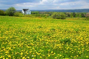
White Hill is located in Pictou County in the province of Nova Scotia, Canada. It was once a rural farming community with a history of Scottish settlement. The population is around 300.
Thorburn is a community in the Canadian province of Nova Scotia, located in Pictou County.
Caribou Mines is a rural community of the Halifax Regional Municipality in the Canadian province of Nova Scotia. The Icelandic settlement Markland was located in Caribou Mines from 1875 to 1882.
Lochaber Mines is a rural community on the Eastern Shore of Nova Scotia, Canada, in the Halifax Regional Municipality. It is located along Route 374 about 14 km (8.7 mi) northeast of Sheet Harbour. The community is located along East River and is near the Marshall Flowage, a large lake at the head of East River. The community is named for Lochaber, located in Scotland. In 1812, Alexander Fraser received a grant of land in the area. Several gold leads were opened by J.H. Anderson in 1887 in the area, however, not much work was done outside of exploratory work.
Liscomb Game Sanctuary is a conservation area that straddles the border of Halifax Regional Municipality and Guysborough County in the Canadian province of Nova Scotia. Nova Scotia Route 374 runs north–south through the sanctuary. Within the sanctuary are two nature reserves and parts of two wilderness areas.
Granton is a community in the Canadian province of Nova Scotia, located in Pictou County. It is the birthplace of Leonard W. Murray. The community was named for Granton, Edinburgh.
Alma is an unincorporated rural community in the Canadian province of Nova Scotia, located in Pictou County. It is named after the Battle of Alma which occurred in 1854 during the Crimean War.
Eureka is a community in the Canadian province of Nova Scotia, located in Pictou County.
Durham is a community in the Canadian province of Nova Scotia, located in Pictou County on Nova Scotia Route 376 alongside the West River of Pictou. The centre of the village is about 10 km up-stream from the town of Pictou. The Durham Presbyterian Church is located near the bridge on the west side of the river, and the Durham Community Hall is on the east side of the river, adjacent to the cemetery.
Cameron Settlement is a small community in the Canadian province of Nova Scotia, located in the Municipality of the District of Saint Mary's in Guysborough County.
Lorne is a community in the Canadian province of Nova Scotia, located in Pictou County along Route 374.
Georgeville is a community on Cape George in Antigonish County, Nova Scotia, Canada.
Dunmaglass is a locality in the Canadian province of Nova Scotia, located in Antigonish County. Formerly a small community, the use of the name as such was rescinded in 1976. Formerly known as both "back settlement of Knoydart" and "Summerville", it was officially named in 1879 after Dunmaglass, Scotland, the home of its first settlers.
Frasers Mills is a community in the Canadian province of Nova Scotia, located in Antigonish County on Nova Scotia Route 316.
There are various Black Lakes in Nova Scotia, Canada. They vary widely in size, depth and usability. Many counties, such as Cumberland, Halifax, Inverness, and Pictou Counties have more than one Black Lake so named, while other counties mentioned in this article have only one named Black Lake.
Woodburn is an unincorporated area in Pictou County, Nova Scotia, Canada.
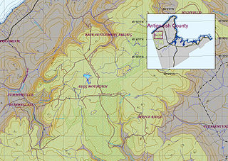
Eigg Mountain is high plateau, part of the highlands of Antigonish County, Nova Scotia, Canada.

A township in Nova Scotia, Canada, was an early form of land division and local administration during British colonial settlement in the 18th century. They were created as a means of populating the colony with people loyal to British rule. They were typically rural or wilderness areas of around 100,000 acres (400 km2) that would eventually include several villages or towns. Some townships, but not all, returned a member to the General Assembly of Nova Scotia; others were represented by the members from the county. Townships became obsolete by 1879 by which time towns and counties had become incorporated.
