Grant Township is a civil township of Keweenaw County in the U.S. state of Michigan. The population was 275 at the 2020 census. Grant Township is one of the most isolated municipalities in Michigan, as it forms the tip of the Keweenaw Peninsula, which projects into Lake Superior.

U.S. Route 75 is a north–south U.S. Highway that runs 1,239 miles (1,994 km) in the central United States. The highway's northern terminus is located at Noyes, Minnesota, which connects to the Canadian border, where it once continued as Manitoba Highway 75 on the other side of the now-closed border crossing. Its southern terminus is located at Interstate 30 (I-30) and I-45 in Dallas, Texas, where it is known as North Central Expressway.

The Eastern Shore is a region of the Canadian province of Nova Scotia. It is the Atlantic coast running northeast from Halifax Harbour to the eastern end of the peninsula at the Strait of Canso.
Route 224 is a collector road in the Canadian province of Nova Scotia. It is located in the Halifax Regional Municipality and Colchester County, connecting Sheet Harbour at Trunk 7 with Milford Station at Exit 9 of Highway 102 and Trunk 14. The route passes through the upper half of the Musquodoboit Valley.
The Ribble way is a long-distance walk between the Lancashire coast and the Yorkshire Dales National Park largely following the course of the River Ribble.

State Road 55 is mainly the internal or secret designation of U.S. Route 19 through Florida, although it has appeared on maps and atlases on several occasions. State Road 55 originates at the Georgia state line north of Ashville, and ends at SR 684 in Bradenton. North of Perry, it is the secret route for US 221, continuing north into Georgia as Georgia State Route 76. South of Memphis, it is a secret designation for US 41; it is also a secret designation for US 301 in the Bradenton - Palmetto area, along a segment co-signed with US 41.

Middle Musquodoboit is a rural community in the Musquodoboit Valley region of Nova Scotia, Canada within the Halifax Regional Municipality, along the Musquodoboit River at the junction of Route 357 with Route 224, 78 kilometres (48 mi) from Dartmouth, Nova Scotia. The community's name comes from the First Nations' word Mooskoduboogwek, which means to suddenly widen out after a narrow entrance at a mouth. For a time after 1883, Middle Musquodoboit was called Laytonville, but at some point reverted to its former name.

Upper Musquodoboit is a forestry and farming community in the northeastern reaches of the Musquodoboit Valley, Nova Scotia, Canada within the Halifax Regional Municipality, 75 kilometres (47 mi) from Downtown Halifax. The community is located along the Musquodoboit River. The community had a population of 473 at the 2006 Census and the community has an area of 380.25 square kilometres (146.82 sq mi). Upper Musquodoboit is situated at the junction of Route 336 with Route 224.
Chaplin is a farming, forestry and cottage community in the eastern Musquodoboit Valley, within the Halifax Regional Municipality Nova Scotia on the St. Mary's Rd. near Route 336. It is colloquially known as "Woodside Road" to locals, the "Chaplin" designation used on maps and for government reference.

Musquodoboit Harbour is a rural community located in Nova Scotia, Canada within the Halifax Regional Municipality. The community is situated on the Eastern Shore at the mouth of the Musquodoboit River. The community lies 45 kilometres east of downtown Halifax. With a hospital, RCMP detachment, postal outlet, schools, recreational center, library, municipal office and other services, Musquodoboit Harbour is a serve centre for many of the surrounding communities.

Elderbank is a farming community in the Musquodoboit Valley area of the Halifax Regional Municipality, Nova Scotia at the junction of Routes 357 and 212. Elderbank is located in the Southeast Branch Musquodoboit. Other communities in this branch include, Meaghers Grant, Nova Scotia.

Canaan is an unincorporated community and census-designated place (CDP) in Shelby Township, Jefferson County, Indiana, United States. As of the 2010 census it had a population of 90.
A roundabout interchange is a type of interchange between a controlled access highway, such as a motorway or freeway, and a minor road. The slip roads to and from the motorway carriageways converge at a single roundabout, which is grade-separated from the motorway lanes with bridges.
West Loon Lake, Nova Scotia is small cottage and recreational community of rural Halifax Regional Municipality Nova Scotia situated at the northeastern corner of the municipality borders the counties of Pictou, and Colchester and Municipal District of Saint Mary's at Trafalgar. A majority of the dwellings are cottages along Loon Lake, the lake which the community derives its name from. The community is on the St. Mary's Rd, between Route 336 and Route 374. The area has an elevation of 180 metres (590 ft) - 230 metres (750 ft), and the community has an area of 5.86 square kilometres (2.26 sq mi).
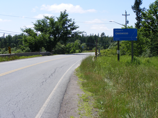
Chaswood is a rural community in the Musquodoboit Valley northwest of Middle Musquodoboit, Nova Scotia in Nova Scotia, Canada. Chaswood is named in honour of Charles Carroll Wood.

Cooks Brook is a small community found in the Southwest Branch Musquodoboit of the Musquodoboit Valley in Nova Scotia, Canada. Cooks Brook is located along the Halifax Regional Municipality/Colchester County border.
Priorswood is a townland and district in northern Coolock, on the Northside of Dublin, Ireland. It is in the jurisdiction of Dublin City Council and forms part of the Dublin 17 postal district.
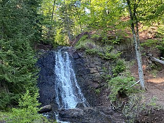
Beaver Dam is a rural community on the Eastern Shore of Nova Scotia, Canada, in the Halifax Regional Municipality. It is located along Route 224, about 21 km (13 mi) northwest of Sheet Harbour and about 19 km (12 mi) southeast of Upper Musquodoboit. Beaver Lake 17, a small Mi'kmaq reserve, is located in the community as well. The community is located adjacent to Lower Beaver Lake.
Sheet Harbour Road is a community of the Halifax Regional Municipality in the Canadian province of Nova Scotia. It is located just five minutes south of Upper Musquodoboit, Nova Scotia. Its name is derived from Route 224, which is the primary route from the Musquodoboit Valley to Sheet Harbour, Nova Scotia.

