
Colchester County is a county in the Canadian province of Nova Scotia. With a population of 50,585 the county is the fourth largest in Nova Scotia. Colchester County is located in north central Nova Scotia.
Barrington, officially named the Municipality of the District of Barrington, is a district municipality in western Shelburne County, Nova Scotia, Canada. Statistics Canada classifies the district municipality as a municipal district.
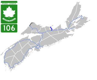
Highway 106 is a 19 km (12 mi) 2-lane limited-access highway located within Pictou County, in the Canadian province of Nova Scotia.
Route 374 is a collector road in the Canadian province of Nova Scotia. It connects New Glasgow at Exit 24 of Nova Scotia Highway 104 with Sheet Harbour at Trunk 7. The highway runs through the Halifax Regional Municipality, Guysborough County & Pictou County.
The Lighthouse Route is a scenic roadway in the Canadian province of Nova Scotia. It follows the province's South Shore for 585 km (364 mi) from Halifax to Yarmouth.
The Glooscap Trail is a scenic roadway in the Canadian province of Nova Scotia.
The Sunrise Trail is a scenic roadway in the Canadian province of Nova Scotia. It is located along the province's North Shore on the Northumberland Strait for 333 km (207 mi) from Amherst to the Canso Causeway.
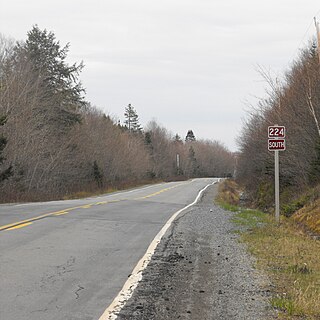
Route 224 is a collector road in the Canadian province of Nova Scotia. It is located in the Halifax Regional Municipality and Colchester County, connecting Sheet Harbour at Trunk 7 with Milford Station at Exit 9 of Highway 102 and Trunk 14. The route passes through the upper half of the Musquodoboit Valley.
The Fundy Shore Ecotour is a former scenic drive and network of tourist destinations in the Canadian province of Nova Scotia and encircles several sub-basins of the Bay of Fundy, which contains the highest tidal range on the planet.

Route 236 is a collector road in the Canadian province of Nova Scotia.
Route 223 is a collector road in the Canadian province of Nova Scotia.

Route 256 is a collector road in the Canadian province of Nova Scotia.
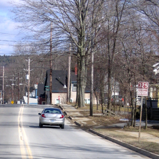
Route 325 is a collector road in the Canadian province of Nova Scotia. It is located in Lunenburg County and connects Colpton at Route 208 with Mahone Bay at Trunk 3.
Route 348 is a collector road in the Canadian province of Nova Scotia.
Upper Stewiacke is a small community located in Colchester County in central Nova Scotia. Upper Stewiacke can be reached by road via Route 289. Upper Stewiacke was founded in 1783 by Matthew Johnson, son of James Johnson, a Grantee of Truro, Nova Scotia. Johnson's supplies had come from Truro, some 20 miles away. In 1983, a special event and reenactment was held to mark the 200th Anniversary of the arrival of Matthew Johnson and his wife Ruth.

Sheepherders Junction is a community in the Canadian province of Nova Scotia, located in Colchester County in the Stewiacke Valley. It is located at the border between Colchester County and Pictou County, Nova Scotia at the intersection of Dryden Lake Road with Route 289. Nearby on Fall Brook, a tributary of the Stewiake River, is the 12 m Fall Brook Fall.
The Stewiacke Valley is a Canadian rural region in central Nova Scotia running from western Pictou County through southern Colchester County to the Shubenacadie River.
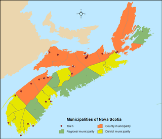
The Canadian province of Nova Scotia is divided into 49 municipalities, of which there are three types: regional (4), town (25), and county or district municipality (20).

