Nova Scotia Route 360.svg

Nova Scotia Route 360
Route information
Maintained by Nova Scotia Department of Transportation and Infrastructure Renewal
Length22 km [1] (14 mi)
Major junctions
South endAylesford Road in Morristown
 Nova Scotia 1.svgNova Scotia 101.svg Trunk 1 / Hwy 101 in Berwick
Nova Scotia Route 221.svg Route 221 in Welsford
North endLong Point Road in Harbourville
Highway system
Provincial highways in Nova Scotia
Nova Scotia Route 359.svg Route 359 Route 362 Nova Scotia Route 362.svg

Route 360 is a collector road in the Canadian province of Nova Scotia.

Canada Country in North America

Canada is a country in the northern part of North America. Its ten provinces and three territories extend from the Atlantic to the Pacific and northward into the Arctic Ocean, covering 9.98 million square kilometres, making it the world's second-largest country by total area. Canada's southern border with the United States is the world's longest bi-national land border. Its capital is Ottawa, and its three largest metropolitan areas are Toronto, Montreal, and Vancouver. As a whole, Canada is sparsely populated, the majority of its land area being dominated by forest and tundra. Consequently, its population is highly urbanized, with over 80 percent of its inhabitants concentrated in large and medium-sized cities, many near the southern border. Canada's climate varies widely across its vast area, ranging from arctic weather in the north, to hot summers in the southern regions, with four distinct seasons.

Nova Scotia Province of Canada

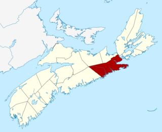
Nova Scotia is one of Canada's three Maritime Provinces, and one of the four provinces that form Atlantic Canada. Its provincial capital is Halifax. Nova Scotia is the second-smallest of Canada's ten provinces, with an area of 55,284 square kilometres (21,300 sq mi), including Cape Breton and another 3,800 coastal islands. As of 2016, the population was 923,598. Nova Scotia is Canada's second-most-densely populated province, after Prince Edward Island, with 17.4 inhabitants per square kilometre (45/sq mi).

Contents

It is located in Kings County and connects Berwick at Trunk 1 with Harbourville.

Kings County, Nova Scotia County in Nova Scotia, Canada

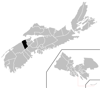
Kings County is a county in the Canadian province of Nova Scotia. With a population of 60,600 in the 2016 Census,, Kings County is the third most populous county in the province. It is located in central Nova Scotia on the shore of the Bay of Fundy, with its northeastern part forming the western shore of the Minas Basin.

Berwick, Nova Scotia Town in Nova Scotia, Canada

Berwick is a Canadian town in Kings County, Nova Scotia. The town is located in the eastern part of the Annapolis Valley on the Cornwallis River. The town site stretches south from the river and Exit 15 of Highway 101 to Highway 1. Berwick occupies 6.80 km2 and has an elevation of 43 m (141 ft) above sea level.

Nova Scotia Trunk 1 highway in Nova Scotia

Trunk 1 is a secondary highway in the Canadian province of Nova Scotia.

It climbs the steep southern slope of the North Mountain in a sharp hairpin turn known locally as "The Oxbow".

North Mountain (Nova Scotia) mountain in Nova Scotia, Canada

North Mountain is a narrow southwest-northeast trending volcanic ridge on the mainland portion of southwestern Nova Scotia, stretching from Brier Island to Cape Split. It forms the northern edge of the Annapolis Valley along the shore of the Bay of Fundy. Together with South Mountain, the two ranges form the Annapolis Highlands region.

View near junction of Nova Scotia Route 360 and Trunk 1 at Berwick, Nova Scotia. NSRoute360 1.png
View near junction of Nova Scotia Route 360 and Trunk 1 at Berwick, Nova Scotia.

Communities

Morristown, Kings County, Nova Scotia human settlement in Canada

Morristown is a community in the Canadian province of Nova Scotia, located in Kings County.

Somerset, Kings County, Nova Scotia human settlement in Canada

Somerset is a rural community in the Canadian province of Nova Scotia, located in Kings County.

Welsford, Kings, Nova Scotia human settlement in Canada

Welsford is a small farming community in the Canadian province of Nova Scotia, located in Kings County.

See also

Related Research Articles

Guysborough County, Nova Scotia County in Nova Scotia, Canada

Guysborough County is a county in the Canadian province of Nova Scotia.

Kings West

Kings West is a provincial electoral district in Nova Scotia, Canada, that elects one member of the Nova Scotia House of Assembly. It includes the towns of Berwick and Kingston, and the village of Greenwood.

Weston, Nova Scotia Community in Nova Scotia, Canada

Weston, Nova Scotia is a small community located in the central part of the Annapolis Valley. It is located about 3 miles (4.82 km) north-west of Berwick, Nova Scotia

Diocese of Nova Scotia and Prince Edward Island

The Diocese of Nova Scotia and Prince Edward Island is a diocese of the Ecclesiastical Province of Canada of the Anglican Church of Canada. It encompasses the provinces of Nova Scotia and Prince Edward Island and has two cathedrals: All Saints' in Halifax and St. Peter's in Charlottetown. It is the oldest Anglican diocese outside the British Islands. Its de facto see city is Halifax, and its roughly 24 400 Anglicans distributed in 239 congregations are served by approximately 153 clergy and 330 lay readers according to the last available data. According to the 2001 census, 120,315 Nova Scotians identified themselves as Anglicans, while 6525 Prince Edward Islanders did the same.

Aylesford, Nova Scotia Village in Nova Scotia, Canada

Aylesford, since its formation, has always been a farming community. It is situated in western Kings County in the Annapolis Valley of Nova Scotia, Canada. The settlement was named after the fourth Earl of Aylesford, Heneage Finch, who was Lord Of The Bedchamber to George III from 1772-1777. The community is located between the North and South Mountains, and is roughly a 15 minute to Canadian Forces Base Greenwood, and a 10 minute drive to its closest neighbour, the Town Of Berwick. Aylesford is located on the Evangeline Trail scenic tourist route, which was named after the epic 1847 H.W. Longfellow poem entitled Evangeline, A Tale of Acadie.

Nova Scotia Power Inc. is a vertically integrated electric utility in Nova Scotia, Canada. It is privately owned by Emera and regulated by the provincial government via the Nova Scotia Utility and Review Board (NSUARB). Nova Scotia Power Inc provides electricity to 500,000 residential, commercial and industrial customers in Nova Scotia.

Route 374 is a collector road in the Canadian province of Nova Scotia. It connects New Glasgow at Exit 24 of Nova Scotia Highway 104 with Sheet Harbour at Trunk 7. The highway runs through the Halifax Regional Municipality, Guysborough County & Pictou County.

Route 328 is a short collector road in the Canadian province of Nova Scotia.

Nova Scotia Route 246 highway in Nova Scotia

Route 246 is a collector road in the Canadian province of Nova Scotia.

1927 Nova Scotia hurricane Category 3 Atlantic hurricane in 1927

The 1927 Nova Scotia hurricane was the deadliest Canadian hurricane since at least 1900. The first observed storm of the season, this cyclone developed from a tropical wave over the deep tropics of the Atlantic Ocean on August 18. Initially a tropical storm, it moved west-northwestward and intensified into a Category 1 hurricane on the modern day Saffir–Simpson hurricane wind scale by August 19. The storm deepened significantly over the next few days, and by August 22, it peaked as a Category 3 hurricane with maximum sustained winds of 125 mph (205 km/h). Around that time, the system began curving northwestward and later northward. By August 23, it turned to the north-northeast and then began weakening on August 24. Thereafter, the storm accelerated toward Atlantic Canada. Late on August 24, the hurricane struck near Yarmouth, Nova Scotia, as a Category 2 hurricane, just before becoming extratropical.

Valley Wildcats ice hockey team

The Valley Wildcats are a Canadian junior ice hockey franchise from the Annapolis Valley region of Nova Scotia. The team is a member of the Maritime Junior A Hockey League and plays in the EastLink Division. They play their home games in the Kings Mutual Century Centre in Berwick, Nova Scotia.

Auburn, Nova Scotia human settlement in Canada

Auburn is a community in the Canadian province of Nova Scotia, located in Kings County, situated west of Aylesford. The second oldest Anglican church in Nova Scotia is situated there, consecrated in 1790 by Bishop Inglis. Modelled on Christopher Wren's London church designs, St. Marys Anglican Church is known as "The Little Wren Church". Complete with a Palladian window over the chancel, it most closely resembles St James's Church, Piccadilly.

Isle Haute

Isle Haute is an island in the upper regions of Bay of Fundy in Nova Scotia, near the entrance to the Minas Basin. It is 16 kilometers from the coast of Harbourville and eight kilometers south-southwest of Cape Chignecto. The island is part of Cumberland County, Nova Scotia and is three kilometres long and 400 metres wide. The Mi'kmaq used the island to make stone tools before Europeans arrived and called the island "Maskusetik", meaning place of wild potatoes.. In 1604, Samuel de Champlain gave the present name to the island, which means "High Island" in French, when he observed the towering bluffs, timber and fresh-water springs. The steep 100 m (328 ft) basalt cliffs of the island are the result from volcanic eruptions in the Jurassic period and may have been connected to the North Mountain volcanic ridge on the mainland 200 million years ago, before the Bay of Fundy was formed.

Ogilvie, Nova Scotia human settlement in Canada

Ogilvie is a community in the Canadian province of Nova Scotia, located in Kings County. It is located between the communities of Burlington and Harbourville.

Hiram Thomas was a Canadian politician. He represented the electoral district of Kings West in the Nova Scotia House of Assembly from 1956 to 1960. He was a member of the Progressive Conservative Party of Nova Scotia.

Edith Hallett Bethune

Edith Hallett Bethune (1890-1970) was a Canadian photographer known for her Pictorialist photography.

References

  1. Atlantic Canada Back Road Atlas ISBN   978-1-55368-618-7 Pages 65, 79