
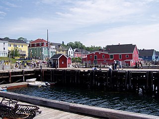
Lunenburg is a port town on the South Shore of Nova Scotia, Canada. Founded in 1753, the town was one of the first British attempts to settle Protestants in Nova Scotia.
Lunenburg County is an historical county and census division on the South Shore of the Canadian province of Nova Scotia. Major settlements include Bridgewater, Lunenburg, and Mahone Bay.
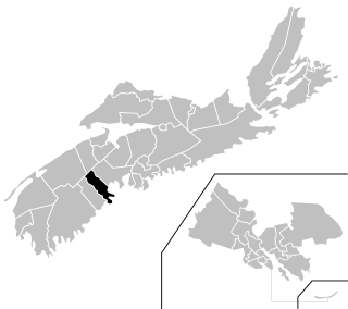
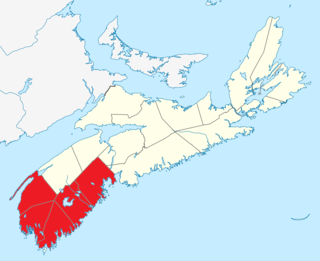
Lunenburg is a provincial electoral district in Nova Scotia, Canada, that elects one member of the Nova Scotia House of Assembly.
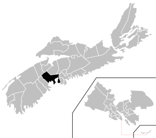
Chester—St. Margaret's is a provincial electoral district in Nova Scotia, Canada, that elects one member of the Nova Scotia House of Assembly. It is located on the South Shore.
Route 203 is a collector road in the Canadian province of Nova Scotia.
Route 208 is a collector highway in the Canadian province of Nova Scotia.

Route 209 is a collector road in the Canadian province of Nova Scotia.

Route 210 is a collector road in the Canadian province of Nova Scotia.
Route 320 is a collector road in the Canadian province of Nova Scotia.
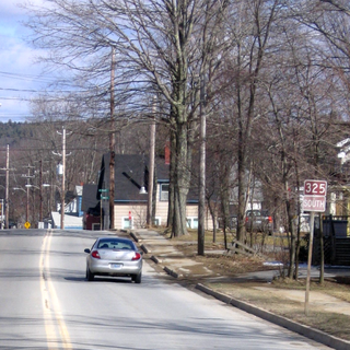
Route 325 is a collector road in the Canadian province of Nova Scotia. It is located in Lunenburg County and connects Colpton at Route 208 with Mahone Bay at Trunk 3.

Route 332 is a collector road in the Canadian province of Nova Scotia. It is located in Lunenburg County, connecting Bridgewater at Trunk 3 with Lunenburg at Trunk 3. It is commonly referred to residences as Riverport Road as the village appears on all major road signage in the county.
Route 329 is a collector road in the Canadian province of Nova Scotia.
Blockhouse is a community in the Canadian province of Nova Scotia, located in the Lunenburg Municipal District in Lunenburg County. It was named after the blockhouses constructed by Captain Ephraim Cook to protect colonizers following a raid in 1756. The final blockhouse in the community burned down in 1874.

The Raid on Lunenburg occurred during the French and Indian War when Mi'kmaw and Maliseet fighters attacked a British settlement at Lunenburg, Nova Scotia on May 8, 1756. The native militia raided two islands on the northern outskirts of the fortified Township of Lunenburg, [John] Rous Island and Payzant Island. According to French reports, the Raiding party killed twenty settlers and took five prisoners. This raid was the first of nine the Natives and Acadians would conduct against the peninsula over a three-year period during the war. The Wabanaki Confederacy took John Payzant and Lewis Payzant prisoner, both of whom left written account of their experiences.

The Raid on Lunenburg occurred during the American Revolution when the US privateer, Captain Noah Stoddard of Fairhaven, Massachusetts, and four other privateer vessels attacked the British settlement at Lunenburg, Nova Scotia on July 1, 1782. The raid was the last major privateer attack on a Nova Scotia community during the war.
Southern Nova Scotia or the South Shore is a region of Nova Scotia, Canada. The area has no formal identity and is variously defined by geographic, county and other political boundaries. Statistics Canada, defines Southern Nova Scotia as an economic region, composed of Lunenburg County, Queens County, Shelburne County, Yarmouth County, and Digby County. According to Statistics Canada, the region had the highest decrease of population in Canada from 2009 to 2010, with a population decrease of 10.2 residents per thousand. The region also has the second-highest median age in Canada at 47.1 years old.

The following outline is provided as an overview of and topical guide to Nova Scotia:

Dr. Jonathan Prescott was a British officer who fought at the Siege of Louisbourg (1745), became the Captain of the militia at Chester, Nova Scotia and later was involved with the Raid on Chester, Nova Scotia (1782). He was the father of Charles Ramage Prescott and uncle of Dr. Samuel Prescott who finished the "midnight ride" begun by Paul Revere.

Ephraim Cook (Cooke) was a mariner and prominent merchant who was instrumental in establishing Halifax, Mahone Bay, Blockhouse and Chebogue, Nova Scotia. He also participated in the French and Indian War, including the Expulsion of the Acadians. He was the first Registrar of Deeds (1767) and the first Justice of the Peace in Yarmouth County.
The Raid on Chester occurred during the American Revolution when the US privateer, Captain Noah Stoddard of Fairhaven, Massachusetts, and four other privateer vessels attacked the British settlement at Chester, Nova Scotia on 30 June 1782. The town was defended by Captain Jonathan Prescott and Captain Jacob Millett.