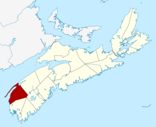
Digby County is a county in the Canadian province of Nova Scotia.
The Cabot Trail is a scenic highway on Cape Breton Island in Nova Scotia, Canada. It is a 298 km (185 mi) loop around the northern tip of the island, passing along and through the Cape Breton Highlands and the Cape Breton Highlands National Park.

The Trans Canada Trail, officially named The Great Trail between September 2016 and June 2021, is a cross-Canada system of greenways, waterways, and roadways that stretches from the Atlantic to the Pacific to the Arctic oceans. The trail extends over 24,000 km (15,000 mi); it is now the longest recreational, multi-use trail network in the world. The idea for the trail began in 1992, shortly after the Canada 125 celebrations. Since then it has been supported by donations from individuals, corporations, foundations, and all levels of government.
Highway 103 is an east-west highway in Nova Scotia that runs from Halifax to Yarmouth.
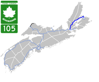
Highway 105 in Nova Scotia represents the Cape Breton Island leg of the Trans-Canada Highway. It runs from the Port Hastings Rotary just east of the Canso Causeway in Port Hastings to the Marine Atlantic ferry terminal in North Sydney, representing a distance of 142 kilometres (88 mi).

The Eastern Shore is a region of the Canadian province of Nova Scotia. It is the Atlantic coast running northeast from Halifax Harbour to the eastern end of the peninsula at the Strait of Canso.

District of Shelburne, officially named the Municipality of the District of Shelburne, is a district municipality comprising the eastern section of Shelburne County, Nova Scotia, Canada, but does not include the Towns of Shelburne or Lockeport. Statistics Canada classifies the district municipality as a municipal district. It is home to the Bowers Meadows Wilderness Area.

Trunk 2 is part of the Canadian province of Nova Scotia's system of Trunk Highways. The route runs from Halifax to Fort Lawrence on the New Brunswick border. Until the 1960s, Trunk 2 was the Halifax area's most important highway link to other provinces, and was part of a longer Interprovincial Highway 2 which ended in Windsor, Ontario. The controlled access Highway 102 and Highway 104 now carry most arterial traffic in the area, while Trunk 2 serves regional and local traffic.

Trunk 4 is part of the Canadian province of Nova Scotia's system of Trunk Highways. The route runs from Highway 104 exit 7 near Thomson Station to Glace Bay. Until the construction of the Trans-Canada Highway, Trunk 4 was a major traffic link in northern Nova Scotia and Cape Breton, and is still used on Cape Breton as an alternative to Highway 105. The highway was originally called the King's Highway, however, this name is no longer applied to the entire road. The only remaining historic section of the highway that maintains the name "King" is King's Road in Sydney.

Trunk 10 is part of the Canadian province of Nova Scotia's system of Trunk Highways. This rural road runs from Bridgewater to Middleton, a distance of 88 kilometres (55 mi).
The Glooscap Trail is a scenic roadway in the Canadian province of Nova Scotia.
The Bras d'Or Lakes Scenic Drive is a scenic roadway on Nova Scotia's Cape Breton Island. It extends around the perimeter of Bras d'Or Lake.
Route 203 is a collector road in the Canadian province of Nova Scotia.
Route 223 is a collector road in the Canadian province of Nova Scotia.
Aulac is a Canadian community in Westmorland County, New Brunswick. As of January 1, 2023 it is part of the Municipality of Tantramar which consists of the former town of Sackville, Village of Dorchester, Pointe de Bute and other rural communities. It is located between the former college town of Sackville and the provincial border with Nova Scotia.

The Municipality of the District of Chester is a Nova Scotia district municipality occupying the northeastern half of Lunenburg County, Canada.
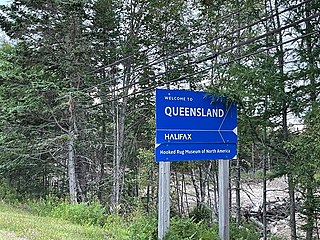
Queensland is a community of the Halifax Regional Municipality in the Canadian province of Nova Scotia.
Noel is a community in the Canadian province of Nova Scotia, located in the Municipal District of East Hants, which is in Hants County, Nova Scotia. The community is most well known for being named after its most prominent resident Noël Doiron and for ship building in the nineteenth century. Noel Doiron is the namesake of the village as well as the surrounding communities of Noel Shore, Nova Scotia, East Noel, Noel Road, Nova Scotia, North Noel Road, Nova Scotia. The earliest recorded reference to the community of "Noel" was by surveyor Charles Morris in 1752. Prior to that date, the area is referred to as "Trejeptick", which first appears in the Colonial Office minutes of Annapolis Royal in 1734. Noel was also the home of the Osmond O'Brien Shipyard.
Benacadie is a community in the Canadian province of Nova Scotia, located in the Cape Breton Regional Municipality.

East Bay is a bay of the Bras d'Or Lake on Cape Breton Island in the Canadian province of Nova Scotia. It lies entirely within Cape Breton County.