
The Trans Canada Trail, officially renamed The Great Trail in September 2016, is a cross-Canada system of greenways, waterways, and roadways that stretches from the Atlantic to the Pacific to the Arctic oceans. The trail extends over 24,000 kilometres ; it is now the longest recreational, multi-use trail network in the world. The idea for the trail began in 1992, shortly after the Canada 125 celebrations. Since then it has been supported by donations from individuals, corporations, foundations, and all levels of government.

Cape Breton Regional Municipality, often referred to as simply CBRM, is the Canadian province of Nova Scotia's second largest municipality and the economic heart of Cape Breton Island. As of 2016 the municipality has a population of 94,285. The municipality was created in 1995 through the amalgamation of eight municipalities located in Cape Breton County.
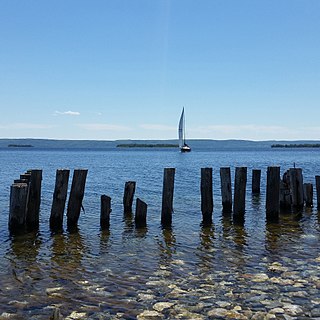
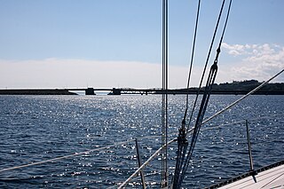
Bras d'Or Lake is an inland sea, or large body of partially fresh/salt water in the centre of Cape Breton Island in the province of Nova Scotia, Canada. Bras d'Or Lake is sometimes referred to as the Bras d'Or Lakes or the Bras d'Or Lakes system; however, its official geographic name is Bras d'Or Lake, as it is a singular entity. Canadian author and yachtsman Silver Donald Cameron describes Bras d'Or Lake as "A basin ringed by indigo hills laced with marble. Islands within a sea inside an island." The lake is connected to the North Atlantic by natural channels; the Great Bras d'Or Channel north of Boularderie Island and the Little Bras d'Or Channel to south of Boularderie Island connect the northeastern arm of the lake to the Cabot Strait. The Bras d'Or is also connected to the Atlantic Ocean via the Strait of Canso by means of a lock canal completed in 1869—the St. Peters Canal, at the southern tip of the lake.
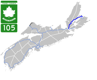
Highway 105 in Nova Scotia represents the Cape Breton Island leg of the Trans-Canada Highway. It runs from the Port Hastings Rotary just east of the Canso Causeway in Port Hastings to the Marine Atlantic ferry terminal in North Sydney, representing a distance of 142 kilometres (88 mi).

Grand Narrows is a community in the Cape Breton Regional Municipality in Nova Scotia, Canada. The community is the birthplace of the longest serving Premier of Nova Scotia, George Henry Murray. The Barra Strait Marina is here, operated by the Grand Narrows Waterfront Development Society.
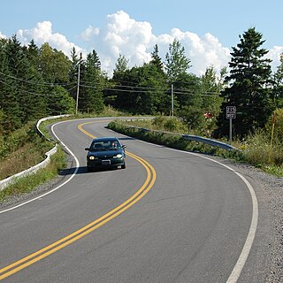
The Bras d'Or Lakes Scenic Drive is a scenic roadway on Nova Scotia's Cape Breton Island. It extends around the perimeter of Bras d'Or Lake.
Route 289 is a collector road in the Canadian province of Nova Scotia.
Route 215 is collector road in the Canadian province of Nova Scotia.
Route 395 is a collector road in the Canadian province of Nova Scotia.
Route 252 is a collector road in the Canadian province of Nova Scotia.
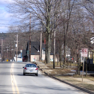
Route 325 is a collector road in the Canadian province of Nova Scotia. It is located in Lunenburg County and connects Colpton at Route 208 with Mahone Bay at Trunk 3.
Route 358 is a collector road in the Canadian province of Nova Scotia.

Route 430 is a 413-kilometre-long (257 mi) paved highway that traverses the Great Northern Peninsula of Newfoundland in the Canadian province of Newfoundland and Labrador. The route begins at the intersection of Route 1 in Deer Lake and ends in St. Anthony. Officially known as the Great Northern Peninsula Highway, it has been designated as the Viking Trail since it is the main auto route to L'Anse aux Meadows, the only proven Viking era settlement in North America. It is the primary travel route in the Great Northern Peninsula and the only improved highway between Deer Lake and St. Anthony. It is the main access route to the Labrador Ferry terminal in St. Barbe.
Iona is a small community in the Canadian province of Nova Scotia, located in Victoria County on Cape Breton Island. It is named after Iona in Scotland. Perched above the Barra Strait between the Great Bras d'Or and Piper's Cove portions of Bras d'Or Lake, Iona is the western terminus of the Barra Strait Bridge carrying Nova Scotia Route 223 across to Grand Narrows village. The Cape Breton and Central Nova Scotia Railway passes through the village, crossing the Barra Strait over the Grand Narrows Bridge on its way east to North Sydney and Sydney.
Big Beach is a community located on the north side of the Boisdale Hills on the east side of the Great Bras D'Or Lake on Provincial Route 223, which runs from Leitches Creek to Little Narrows, through Central Cape Breton Island in the Canadian province of Nova Scotia. Located on the "Bras D'Or Lakes Scenic Drive" it is part of the Cape Breton Regional Municipality in Central Cape Breton Island.

The Barra Strait is a 1.22 km (0.76 mi) wide channel located in the Canadian province of Nova Scotia. It connects the northern and southern basins of Bras d'Or Lake, an inland saltwater body that dominates the centre of Cape Breton Island. The border between two of Cape Breton Island's counties runs through the strait; the community of Grand Narrows, in Cape Breton County, is situated on the eastern shore while the community of Iona, in Victoria County is situated on the western shore.

The Grand Narrows Bridge is a Canadian railway bridge crossing between Victoria County, Nova Scotia, and Cape Breton County. At 516.33 m (1,694 ft), it is the longest railroad bridge in the province. The bridge incorporates a swing span at its eastern end to permit the continued passage of marine traffic through the strait.
The Barra Strait Bridge is a Canadian road bridge crossing between Victoria County, Nova Scotia, and Cape Breton County. The Barra Strait Bridge crosses the Barra Strait of Bras d'Or Lake, carrying Nova Scotia Route 223 between Iona, Victoria County, on the West side, and Grand Narrows, Cape Breton County on the east side.
