Nova Scotia Highway 103

Last updated

Nova Scotia 103.svg

Highway 103

Fishermen's Memorial Highway
Nova Scotia Highway 103
Highway 103 highlighted in red
Route information
Maintained by Nova Scotia Department of Transportation and Infrastructure Renewal
Length291.3 km [1]  (181.0 mi)
Existed1949–present
Major junctions
East endNova Scotia 102.svg Hwy 102 in Halifax
Major intersections
West endHardscratch Road in Yarmouth
Location
Country Canada
Province Nova Scotia
Counties Halifax Regional Municipality, Lunenburg, Queens, Shelburne, Yarmouth
Towns Yarmouth, Shelburne, Bridgewater, Lunenburg, Mahone Bay
Highway system
Nova Scotia 102.svg Hwy 102 Nova Scotia Highway 104 (TCH).svg Hwy 104 (TCH)

Highway 103 is an east-west highway in Nova Scotia that runs from Halifax to Yarmouth.

Contents

The highway follows a route of 291 kilometres (181 mi) along the province's South Shore region fronting the Atlantic coast. The route parallels its predecessor, local Trunk 3. The highway varies from 2-lane controlled access to 2-lane local secondary roads on the section between Yarmouth and Hebbville. East of Hebbville to Ingramport, the highway is 2-lane controlled access, with the exception of a 3 km (2 mi) 4-lane divided freeway near Chester. From just west of Ingramport (exit 5A), to the interchange with Highway 102 (near Bayers Lake) in Halifax, the highway is 4-lane divided freeway. Same as Highway 101, kilometre markers increase running west-to-east, increasing from Yarmouth to Halifax; with exit numbers running east-to-west, increasing from Halifax to Yarmouth.

In 2013, Highway 103 was redesignated as the Fishermen's Memorial Highway.

History

The highway has developed sporadically since the 1970s, with the 2-lane controlled access portion to Bridgewater being largely responsible for the abandonment of CN Rail's South Shore line, the former Halifax and Southwestern Railway.[ citation needed ]

In November 1998, construction was completed that twinned a five kilometer section of highway between exit 2 and exit 3. [2] In November 2006, construction was completed that twinned 15 kilometres of highway between exit 3 and exit 5. [3] In December 2006, an 8.3 kilometre bypass around Barrington was completed. [4]

In late September 2015 a new section of highway was opened to bypass the Port Joli area. [5] In November 2016, a new section was completed which bypassed Port Mouton. Residents complained that the single exit east of the community had lengthened the trip for people heading west from Port Mouton.

The new interchange in Ingramport (exit 5A) opened in January 2017.

Work on twinning Highway 103 from exit 5 (Tantallon) to exit 5A (Ingramport) began in February, 2018 and was completed in December, 2020. Twinning from exit 5A (Ingramport) to exit 6 (Hubbards) started in 2020 with an expected completion date of late 2023.

Names of Highway 103

Safety concerns

Between 2006 and 2009, there were 29 deaths on the highway. [6] In 2009, it was considered Nova Scotia's deadliest highway and was ranked the second most dangerous highway in Canada by the Canadian Automobile Association. [7] [8] In 2009 alone, ten people died in automobile accidents on the highway, according to the Nova Scotia Department of Transportation and Infrastructure Renewal. [9] Between 2008 and 2012, there were 22 fatalities on the highway. [10]

In September 2018, local residents raised concern over the presence of a road sign on the highway, near the turnoff to Port Mouton, that had a very confusing appearance, looking like a patchwork of several other road signs. It was supposedly revealed when a hotel removed its billboard advertisement, revealing the sign below. [11]

Exit list

CountyLocationkm [1] miExitDestinationsNotes
Halifax Halifax 0.00.01BNova Scotia 102.svgNova Scotia 101.svgOntario M502.svg Hwy 102 to Hwy 101  Halifax, Dartmouth, Windsor, Airport, Truro, Bedford Hwy 103 eastern terminus.
0.40.251D Dunbrack Street Eastbound exit only.
1.20.752Nova Scotia 3.svgNova Scotia Route 333.svg Trunk 3 west (St. Margarets Bay Road) to Route 333 (Lighthouse Route) Beechville, Lakeside, Peggys Cove Westbound signed as exits 2A (west) and 2B (east)
Timberlea 5.63.53Nova Scotia 3.svg To Trunk 3  / Timberlea Village Parkway
Hubley 12.77.94Nova Scotia 3.svg Trunk 3  Timberlea, Five Island Lake
Upper Tantallon 19.612.25Nova Scotia Route 213.svgNova Scotia 3.svgNova Scotia Route 333.svg Route 213 (Hammond's Plains Road) to Trunk 3  / Route 333  Peggys Cove, Bedford
29.918.65ANova Scotia 3.svg To Trunk 3  Ingramport, Black Point, Boutiliers Point
Lunenburg Hubbards 40.825.46Nova Scotia 3.svgNova Scotia Route 329.svg Trunk 3  / Route 329  Queensland, Blandford
East River 50.031.17Nova Scotia 3.svgNova Scotia Route 329.svg Trunk 3  / Route 329  Chester, Blandford
Chester 57.235.58Nova Scotia 14.svg Trunk 14  Chester, Windsor
Chester Basin 61.338.19Nova Scotia 12.svg Trunk 12  Kentville, New Ross
Mahone Bay 75.046.610Nova Scotia 3.svg Trunk 3  Lunenburg, Martin's River
Blockhouse 79.949.611Nova Scotia Route 324.svgNova Scotia Route 325.svg Route 324 (Cornwall Road) to Route 325  Mahone Bay, Lunenburg
Bridgewater 91.656.912Nova Scotia 10.svgNova Scotia Route 331.svgNova Scotia Route 332.svg Trunk 10 to Route 331  / Route 332  West LaHave, East LaHave, Riverport
91.857.0Crosses the LaHave River
93.057.812ABridgewater Business ParkInterchange under construction (opening in Fall 2024)
94.858.913Nova Scotia Route 325.svgNova Scotia Route 331.svg Route 325 (Victoria Road) to Route 331  Bakers Settlement, Wileville
Hebb's Cross 101.463.014Nova Scotia 3.svg Trunk 3 east Hebbville, Bridgewater At-grade
Italy Cross 107.967.015Italy Cross Road Crousetown, Petite Riviere, Broad Cove, Rissers Beach Provincial ParkAt-grade
Middlewood 111.769.416Hirtle Road / Camperdown School Road Vogler's Cove, Broad Cove, Camperdown At-grade
Queens 122.476.117Nova Scotia Route 331.svg Route 331  East Port Medway, Voglers Cove, Charleston, Cherry Hill At-grade
Crosses the Medway River
124.277.217APort Medway Road Mill Village, Port Medway, East/West Berlin, Charleston At-grade
130.581.118Nova Scotia 3.svg Trunk 3 west Brooklyn, Liverpool At-grade
Liverpool 136.985.119Nova Scotia 8.svgNova Scotia 3.svg Trunk 8 to Trunk 3  Milton, Brooklyn
137.585.4Crosses the Mersey River
140.387.220ANova Scotia 3.svg To Trunk 3 (Old Port Mouton Road) White Point, Hunt's Point At-grade
153.295.221Nova Scotia 3.svg To Trunk 3  Summerville Centre, Hunt's Point, White Point At-grade
Port Mouton 155.996.9 Trunk 3 eastIntersection closed, use exit 21 [12]
160.799.922 Trunk 3 west Port Joli, East Side Port l'Hébert, Kejimkujik National Park (Seaside Adjunct) At-grade; Trunk 3 is unsigned
163.3101.5 Trunk 3 east Port Joli Intersection closed, use exit 22 [12]
Shelburne Sable River 176.6109.723Nova Scotia 3.svg Trunk 3 west Lockeport At-grade
Jordan Falls 190.3118.224Nova Scotia 3.svg Trunk 3 east / Lake John Road Lockeport At-grade
190.8118.6Jordan Branch Road Jordan Branch, Jordan Ferry, Jordan Bay At-grade
196.0121.825Nova Scotia 3.svg Trunk 3 west Shelburne At-grade
Shelburne 200.0124.326Nova Scotia Route 203.svg Route 203  Ohio, East Kemptville At-grade
Birchtown 206.9128.627Nova Scotia 3.svg Trunk 3 east Gunning Cove, Ingomar At-grade
Clyde River 220.3136.928Nova Scotia Route 309.svg Route 309 south (South Road) / Quinns Falls Road Port Clyde, Eel Bay, Port La Tour At-grade
Barrington 230.0142.929Nova Scotia 3.svgNova Scotia Route 309.svg Trunk 3 west to Route 309  Port La Tour At-grade
Riverhead 234.3145.630Nova Scotia 3.svg To Trunk 3  Barrington Passage, Lower Woods Harbour, Upper Woods Harbour
Yarmouth Pubnico 256.0159.131Nova Scotia 3.svgNova Scotia Route 335.svg To Trunk 3  / Route 335  Lower Argyle At-grade
Argyle 268.4166.832Nova Scotia 3.svg Trunk 3 east Central Argyle, Argyle Head East end of Trunk 3 unsigned concurrency; at-grade, proposed interchange
269.0167.1Crosses the Argyle River
269.4167.432ANova Scotia 3.svg Trunk 3 west Glenwood West end of Trunk 3 unsigned concurrency; at-grade, proposed intersection closure
276.2171.6Eel Lake Road / Belleville RoadAt-grade
276.8–
277.4
172.0–
172.4
Crosses Eel Lake
Tusket 281.2174.733Nova Scotia Route 308.svgNova Scotia 3.svg Route 308 to Trunk 3  Quinan
282.4175.5Crosses the Tusket River
Yarmouth 291.3181.0Hardscratch Road Brooklyn Hwy 103 western terminus
292.1181.5Nova Scotia 3.svgNova Scotia 101.svgNova Scotia 1.svgOntario M508.svg Trunk 3 (Starrs Road) to Hwy 101  / Trunk 1  Ferry
1.000 mi = 1.609 km; 1.000 km = 0.621 mi

Communities

Related Research Articles

<span class="mw-page-title-main">Queens County, Nova Scotia</span> County in Nova Scotia, Canada

Queens County is a county in the Canadian province of Nova Scotia.

Route 2 is a major provincial highway in the Canadian province of New Brunswick, carrying the main route of the Trans-Canada Highway in the province. The highway connects with Autoroute 85 at the border with Quebec and Highway 104 at the border with Nova Scotia, as well as with traffic from Interstate 95 in the U.S. state of Maine via the short Route 95 connector. A core route in the National Highway System, Route 2 is a four-lane freeway in its entirety, and directly serves the cities of Edmundston, Fredericton, and Moncton.

Autoroute 20 is a Quebec Autoroute, following the Saint Lawrence River through one of the more densely populated parts of Canada, with its central section forming the main route of the Trans-Canada Highway from the A-25 interchange to the A-85 interchange. At 585 km (363.5 mi), it is the longest Autoroute in Quebec. It is one of two main links between Montreal and Quebec City; the other is the A-40.

<span class="mw-page-title-main">Halifax and South Western Railway</span>

The Halifax and South Western Railway was a historic Canadian railway operating in the province of Nova Scotia.
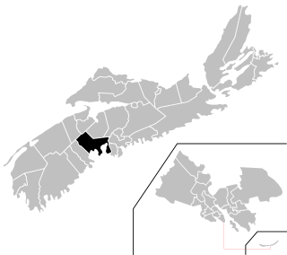
<span class="mw-page-title-main">Port Joli, Nova Scotia</span>

Port Joli is a small village located along Highway 103 on the southwest coast of Region of Queens Nova Scotia, Canada. It is about 20 miles from Liverpool, Nova Scotia, the nearest significant town, and 120 miles from Halifax, Nova Scotia, the provincial capital. Port Mouton is about midway between Port Joli and Liverpool. The village's name, Port Joli, comes from the French joli, meaning "pretty."

<span class="mw-page-title-main">Nova Scotia Highway 101</span> Highway in Nova Scotia

Highway 101 is an east-west highway in Nova Scotia that runs from Bedford to Yarmouth.

Highway 102 is a north–south highway in the Canadian province of Nova Scotia that runs from Halifax to Onslow, immediately north of the town of Truro. It is the busiest highway in Atlantic Canada.

Highway 104 in Nova Scotia, Canada, runs from Fort Lawrence at the New Brunswick border near Amherst to River Tillard near St. Peter's. Except for the portion on Cape Breton Island between Port Hawkesbury and St. Peter's, it forms the main route of the Trans-Canada Highway across the province.

<span class="mw-page-title-main">Nova Scotia Highway 105</span> Highway in Nova Scotia

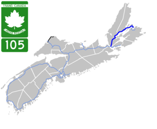
Highway 105 in Nova Scotia represents the Cape Breton Island leg of the Trans-Canada Highway. It runs from the Port Hastings Rotary just east of the Canso Causeway in Port Hastings to the Marine Atlantic ferry terminal in North Sydney, representing a distance of 142 kilometres (88 mi).

<span class="mw-page-title-main">Nova Scotia Highway 107</span> Highway in Nova Scotia

Highway 107 in Nova Scotia runs through the eastern suburbs of the Halifax Regional Municipality, from the Burnside Industrial Park in Dartmouth to an intersection with Trunk 7 in Musquodoboit Harbour. It is 43.2 km (26.8 mi) long, and is mostly two lane, controlled access highway.

<span class="mw-page-title-main">Nova Scotia Highway 118</span> Highway in Nova Scotia

Highway 118 is a divided highway connecting Dartmouth with Highway 102 at Fall River, 14 kilometres (8.7 mi) to the north in the Canadian province of Nova Scotia.

<span class="mw-page-title-main">Nova Scotia Highway 125</span> Highway in Nova Scotia

Highway 125 is a 28 km long controlled-access highway located in Nova Scotia's Cape Breton Regional Municipality. The provincial government named it Peacekeepers Way on August 18, 2008. Part of the provincial 100-series arterial highway network, Highway 125 encircles the west side of Sydney Harbour, from an interchange with Highway 105 at Sydney Mines to Trunk 4 immediately east of Sydney.

<span class="mw-page-title-main">Nova Scotia Trunk 3</span> Highway in Nova Scotia, Canada

Nova Scotia Trunk 3 is an east-west trunk highway in Nova Scotia. The route runs from Halifax to Yarmouth, along the South Shore. Trunk 3's status as an important regional highway link has been superseded by the parallel Highway 103.

Route 213 is a collector road in the Canadian province of Nova Scotia. It is located in the Halifax Regional Municipality, connecting Bedford at Trunk 2 with Upper Tantallon at Trunk 3 with interchanges with Highway 102 and Highway 103 located near the termini.

The Lighthouse Route is a scenic roadway in the Canadian province of Nova Scotia. It follows the province's South Shore for 585 km (364 mi) from Halifax to Yarmouth.
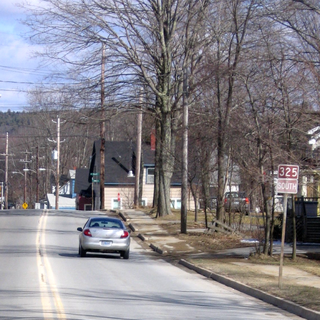
Mill Village is a Canadian rural community in the Region of Queens Municipality, Nova Scotia. It developed in relation to the lumber industry. Located inland from the Atlantic coast, Mill Village was the site of Canada's first satellite earth station constructed in the 1960s.
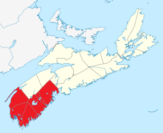
<span class="mw-page-title-main">Outline of Nova Scotia</span> Overview of and topical guide to Nova Scotia

The following outline is provided as an overview of and topical guide to Nova Scotia:

<span class="mw-page-title-main">Administrative divisions of Nova Scotia</span> Local governance within Nova Scotia

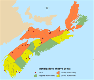
The Canadian province of Nova Scotia is divided into 49 municipalities, of which there are three types: regional (4), town (25), and county or district municipality (20).

References

  1. 1 2 Google (August 20, 2019). "Highway 103 in Nova Scotia" (Map). Google Maps . Google. Retrieved August 20, 2019.
  2. Four Lanes Open on Highway 103 Government of Nova Scotia
  3. Highway 103 Greatly Improved Government of Nova Scotia
  4. Barrington Bypass Completed Government of Nova Scotia
  5. Verge, Brittany W. (October 14, 2015). "Smoothing out Highway 103: Port Joli bypass opens to traffic". Queens County Advance. Transcontinental Media. Retrieved 30 May 2017.
  6. Canada's most notorious highways CBC.ca
  7. "Nova Scotia's Highway 101 to be widened". CBC News. March 6, 2009. Retrieved 2017-06-26.
  8. "CAA NEO Blog". Archived from the original on 2012-04-28. Retrieved 2010-01-16. "The Top 12 Most Dangerous Highways in Canada"
  9. 10 most dangerous roads in Canada Archived 2010-10-21 at the Wayback Machine MSN.ca
  10. Highway 103 safety review launched in Nova Scotia CBC.ca
  11. "Is this road sign in Canada the world's most confusing?". BBC. 11 September 2018. Retrieved 13 September 2018.
  12. 1 2 "Highway 103: Broad River to Port Joli Phase 1" (PDF). Nova Scotia Transportation & Infrastructure Renewal. Government of Nova Scotia. January 2014. Retrieved August 20, 2019.
Template:Attached KML/Nova Scotia Highway 103
KML is from Wikidata