
Highway 111 is a 13-kilometre (8 mi) controlled-access highway in Halifax Regional Municipality, Nova Scotia, Canada.
Highway 103 is an east-west highway in Nova Scotia that runs from Halifax to Yarmouth.
Highway 101 is an east-west highway in Nova Scotia that runs from Bedford to Yarmouth.

Highway 102 is a north-south highway in the Canadian province of Nova Scotia that runs from Halifax to Onslow, immediately north of the town of Truro. It is the busiest highway in Atlantic Canada.
Highway 104 in Nova Scotia, Canada, runs from Fort Lawrence at the New Brunswick border near Amherst to River Tillard near St. Peter's. Except for the portion on Cape Breton Island between Port Hawkesbury and St. Peter's, it forms the main route of the Trans-Canada Highway across the province.
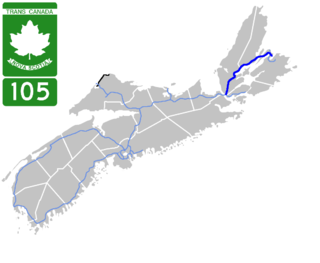
Highway 105 in Nova Scotia represents the Cape Breton Island leg of the Trans-Canada Highway. It runs from the Port Hastings Rotary just east of the Canso Causeway in Port Hastings to the Marine Atlantic ferry terminal in North Sydney, representing a distance of 142 kilometres (88 mi).

Highway 107 in Nova Scotia runs through the eastern suburbs of the Halifax Regional Municipality, from the Burnside Industrial Park in Dartmouth to an intersection with Trunk 7 in Musquodoboit Harbour. It is 43.2 km (26.8 mi) long, and is mostly two lane, controlled access highway.

Highway 125 is a 28 km long controlled-access highway located in Nova Scotia's Cape Breton Regional Municipality. The provincial government named it Peacekeepers Way on August 18, 2008. Part of the provincial 100-series arterial highway network, Highway 125 encircles the west side of Sydney Harbour, from an interchange with Highway 105 at Sydney Mines to Trunk 4 immediately east of Sydney.
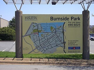
Burnside is a Canadian urban neighbourhood located along the northeast shore of Bedford Basin of the Halifax Regional Municipality in Dartmouth, Nova Scotia.
Nova Scotia Trunk 7 is part of the Canadian province of Nova Scotia's system of Trunk Highways. The route runs from Bedford to Antigonish, along the Eastern Shore for a distance of 269 kilometres (167 mi). Part of Trunk 7 is known as the Marine Drive.

Highway 162 is a two-lane controlled access highway on Boularderie Island in Nova Scotia, Canada.

Trunk 1 is part of the Canadian province of Nova Scotia's system of Trunk Highways.
Trunk 2 is part of the Canadian province of Nova Scotia's system of Trunk Highways. The route runs from Halifax to Fort Lawrence on the New Brunswick border. Until the 1960s, Trunk 2 was the Halifax area's most important highway link to other provinces, and was part of a longer Interprovincial Highway 2 which ended in Windsor, Ontario. The controlled access Highway 102 and Highway 104 now carry most arterial traffic in the area, while Trunk 2 serves regional and local traffic.
Nova Scotia Trunk 3 is an east-west trunk highway in Nova Scotia. The route runs from Halifax to Yarmouth, along the South Shore. Trunk 3's status as an important regional highway link has been superseded by the parallel Highway 103.
Route 213 is a collector road in the Canadian province of Nova Scotia. It is located in the Halifax Regional Municipality, connecting Bedford at Trunk 2 with Upper Tantallon at Trunk 3 with interchanges with Highway 102 and Highway 103 located near the termini.

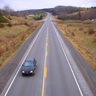
The 100-Series Highways are a series of arterial highways in the Canadian province of Nova Scotia.

Route 333 is a collector road in the Canadian province of Nova Scotia.
The Bedford Highway is a highway in the Halifax Regional Municipality, Nova Scotia that is part of Trunk 2. It runs around the western side of the Bedford Basin. The highway starts at the Windsor Street intersection on the Halifax Peninsula and passes by the communities of Fairview, Rockingham, and Bedford, where it becomes part of Trunk 1 to Highway 101.

Halifax, Nova Scotia, is a major multi-modal transportation centre for freight and passengers in Atlantic Canada. Halifax, formally known as the Halifax Regional Municipality (HRM), is the capital and largest municipality of the Canadian province of Nova Scotia.
Dunbrack Street is a 9.2 km (5.7 mi) arterial road in Mainland Halifax, Nova Scotia. It runs from Route 306 in Spryfield to Kearney Lake Road in Rockingham. Prior to 2019, Dunbrack Street ran from Kearney Lake Road in Rockingham to Main Avenue in Fairview. The remaining section was named Northwest Arm Drive until 2019. The former Northwest Arm section is assigned Trunk 32 by the provincial transportation department as an unsigned highway.