
Shelburne County is a county in the Canadian province of Nova Scotia.
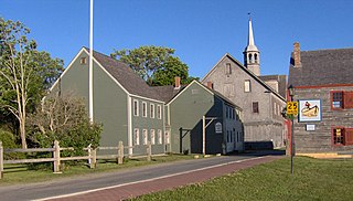
Beaubassin was an important Acadian village and trading centre on the Isthmus of Chignecto in what is now Nova Scotia, Canada. The area was a significant place in the geopolitical struggle between the British and French empires. It was established in the 1670s on an upland close to an extensive area of saltwater marsh. Settlers reclaimed the land to engage in cattle ranching and trade.
Shelburne is a town located in southwestern Nova Scotia, Canada.
Upper Economy is a rural area of approximately 50 residents and 5 km2 located along Trunk 2 in western Colchester County, Nova Scotia. It stretches from along the north shoreline of the western end of Cobequid Bay north into the lower slopes of the Cobequid Mountains. Upper Economy is considered locally to be part of the rural community of Economy. It borders Little Bass River to the west and the former community of Pleasant Hills to the north.
Great Village is a rural community of approximately 500 people located along Trunk 2 and the north shore of Cobequid Bay in Colchester County, Nova Scotia. It is considered locally to incorporate the areas of Highland Village to the west and Scrabble Hill to the north northwest.
Wallace is a rural community in Cumberland County, Nova Scotia, Canada.

Malagash is a dispersed community on the Malagash Peninsula in Cumberland County, Nova Scotia, Canada.

District of Shelburne, officially named the Municipality of the District of Shelburne, is a district municipality comprising the eastern section of Shelburne County, Nova Scotia, Canada, but does not include the Towns of Shelburne or Lockeport. Statistics Canada classifies the district municipality as a municipal district. It is home to the Bowers Meadows Wilderness Area.
Alexander McNutt was a British Army officer, colonist and land agent, responsible for seeing an approximate 500 Ulster Scottish emigrants arrive in Nova Scotia during the early 1760s.

The Nova Scotia peninsula is a peninsula on the Atlantic coast of North America. It is called Enmigtaqamu'g in the Mi'kmaw language.
Manganese Mines is an unincorporated community in Colchester County, Nova Scotia, Canada.

Onslow is a rural, unincorporated Canadian community in central Colchester County, Nova Scotia. The community is located along the north bank of the Salmon River, opposite the town of Truro and is largely a farming area. The area was first settled by Acadians and resettled after their expulsion as Onslow Township in 1761 by Irish emigrants under Colonel McNutt. The township is believed to have been named after Arthur Onslow.
Brookfield is a Canadian rural community located in southern Colchester County, Nova Scotia, Canada. Brookfield is a growing community in the heart of Nova Scotia, just forty minutes from the provincial capital of Halifax, thirty minutes from the Stanfield International Airport and ten minutes from the Town of Truro. The community hosts both levels of public schools, two churches, restaurants, a bakery, a service station, a sportsplex, an 18 hole golf course, and a volunteer fire service.
Masstown, formerly Cobequid, is a farming community located approximately 17 kilometres (11 mi) from Truro, Nova Scotia.

Birchtown is a community and National Historic Site in the Canadian province of Nova Scotia, located near Shelburne in the Municipal District of Shelburne County. Founded in 1783, the village was the largest settlement of Black Loyalists and the largest free settlement of ethnic Africans in North America in the eighteenth century. The two other significant Black Loyalist communities established in Nova Scotia were Brindley town and Tracadie. Birchtown was named after British Brigadier General Samuel Birch, an official who helped lead the evacuation of Black Loyalists from New York.
Scotch Village is an unincorporated community on the Kennetcook River in the Canadian province of Nova Scotia, located in the Municipality of West Hants. This area was part of Newport Township at the time of settlement primarily by Rhode Island Planters in the early 1760s. It was referred to as “Scotchman’s Dyke” or “Scotch Village”, due to settlement of early families of Scottish descent. Prior to the arrival of the Planters, Scotch Village had been the home of Mi'kmaq and Acadians.
Greenfield is a small rural community in the Canadian province of Nova Scotia, located in Colchester County. It is two miles south of the Salmon River and six miles east of Truro, NS. The name is intended to describe the landscape, annotated by surveyor Alexander Miller around 1817.
North River is a community in the Canadian province of Nova Scotia, located in Colchester County near Truro, Nova Scotia. It was settled in the 1760s as part of what was then Onslow Township, one of the many townships set up by the British Government in Halifax to encourage planters to come to Nova Scotia to work the land. Onslow Township was settled by New England Planters from the area around Boston, Massachusetts and from New Hampshire. The original occupation of the new immigrants was farming.
Portapique is a rural community in the Canadian province of Nova Scotia, located in Colchester County. It has about 100 residents in winter and increases to 250 residents in summer.

Stephen Blucke or Stephen Bluck was a Black Loyalist in the American Revolutionary War and one the commanding officers of the British Loyalist provincial unit, the Black Company of Pioneers. He was one of 3,000 people who left New York for Nova Scotia on British ships. He settled in a town designed for African-Americans, Birchtown, Nova Scotia. He was a leader in the town, called a magistrate and commissioned as lieutenant colonel of the Black Militia of the greater Shelburne district by Governor John Parr. He worked with a surveyor to identify the area that would become Birchtown and was involved in coordinating labour for roads and other public works. He lived the life of a middle-class person while his neighbors lived a life of poverty. He had a substantial well-built house, while most people lived in simple housing. He was a go-between for employment of some of the townspeople in labor or similar jobs.

