
Glenmore in Nova Scotia
Glenmore is a rural community of the Halifax Regional Municipality in the Canadian province of Nova Scotia.
Coordinates: 45°4′15.1″N63°8′59.3″W / 45.070861°N 63.149806°W
Glenmore is a rural community of the Halifax Regional Municipality in the Canadian province of Nova Scotia.
Coordinates: 45°4′15.1″N63°8′59.3″W / 45.070861°N 63.149806°W

The Arctic Archipelago, also known as the Canadian Arctic Archipelago, is an archipelago lying to the north of the Canadian continental mainland, excluding Greenland.
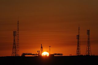
The Baikonur Cosmodrome is a spaceport in an area of southern Kazakhstan leased to Russia. The Cosmodrome is the world's first spaceport for orbital and human launches and the largest operational space launch facility. All crewed Russian spaceflights are launched from Baikonur.
Mercedes-AMG GmbH, commonly known as AMG, is the high-performance subsidiary of Mercedes-Benz AG. AMG independently hires engineers and contracts with manufacturers to customize Mercedes-Benz AMG vehicles. The company has its headquarters in Affalterbach, Baden-Württemberg, Germany.

The Halifax Regional Municipality has a number of parks and recreation areas in urban and rural settings.

CKTY-FM is a radio station in Truro, Nova Scotia. Owned by Bell Media, it broadcasts a country format branded as Pure Country 99.5.
CKTO-FM is a Canadian radio station, broadcasting at 100.9 FM in Truro, Nova Scotia. The station airs an adult hits format and is branded as Bounce 100.9. The station has been on the air since 1965.

Vimont is a provincial electoral district in the Laval region of Quebec, Canada, that elects members to the National Assembly of Quebec. It consists of part of the city of Laval.

Rangárþing eystra is a municipality located in southern Iceland in the Southern Region, between Eystri Rangá in the west and Jökulsá á Sólheimasandi in the east. The largest settlements are Skógar and Hvolsvöllur.
Long Lake could mean the following :
Little Lake could mean the following :
There are many lakes named Rocky Lake in Nova Scotia, Canada.
Bluie was the United States military code name for Greenland during World War II. It is remembered by the numbered sequence of base locations identified by the 1941 United States Coast Guard South Greenland Survey Expedition, and subsequently used in radio communications by airmen unfamiliar with pronunciation of the Inuit and Old Norse names of those locations. These were typically spoken BLUIE (direction) (number), with direction being east or west along the Greenland coast from Cape Farewell.
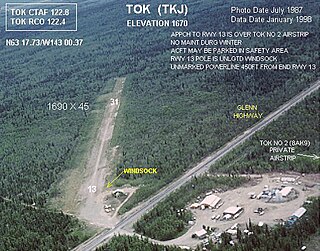
Tok Airport was a state-owned public-use airport located two nautical miles (4 km) south of the central business district of Tok, in the Southeast Fairbanks Census Area of the U.S. state of Alaska.
The River Philip is a river contained entirely within Cumberland County, Nova Scotia, Canada.

The Stewiacke River is a river in the Canadian province of Nova Scotia that starts at Round Lake in Pictou County and flows into the Shubenacadie River in Colchester County running through the Stewiacke Valley.

Sherbrooke is a municipality that holds community status in Prince Edward Island, Canada.

Indian River is a 59.1-mile-long (95.1 km) tributary of the Manistique River on the Upper Peninsula of Michigan in the United States. It rises out of Hovey Lake at 46°17′36″N86°42′20″W on Hiawatha National Forest land in Alger County and flows south and east through a lake district and on through Schoolcraft County. The river flows into the 8,659 acre (35 km²) Indian Lake at 46°17′36″N86°42′20″W and flows out at 45°59′30″N86°17′15″W. It then flows east and south about 2.5 miles where it merges with the Manistique River, which then flows through Manistique and into Lake Michigan at 45°56′56″N86°14′45″W.
| | This Halifax County, Nova Scotia location article is a stub. You can help Wikipedia by expanding it. |