Economy is an unincorporated rural community situated along the north shore of the Minas Basin/Cobequid Bay, at approximately 45°23'N, 63°54'W, in Colchester County, Nova Scotia. In the late 19th century, it was known for its shipbuilding industry.

East Hants, officially named the Municipality of the District of East Hants, is a district municipality in Hants County, Nova Scotia, Canada. Statistics Canada classifies the district municipality as a municipal district.

The Shubenacadie River is a river in Nova Scotia, Canada. It has a meander length of approximately 72 km from its source at Shubenacadie Grand Lake to its mouth at the historic seaport village of Maitland on Cobequid Bay, site of the building of the William D. Lawrence, the largest wooden ship ever built in Canada. In 2009, the I Backpack Canada blog named the Shubenacadie one of the top five whitewater rivers in Canada. The lower 30 km of the river is tidal and the river experiences a tidal bore twice daily, with some bores reaching up to 3 m in height at certain points along the river. Local tourism operators offer adventure seekers a chance to ride with the bore on high-horse power Zodiac Hurricanes. Tidal Bore Rafting was invented at the Tidal Bore Rafting Resort by H. Knoll. It is also a popular surfing spot for experienced Sea Kayakers.
The Wentworth Valley is a valley in the Cobequid Mountains of northwestern Nova Scotia, Canada. It comprises the lowest elevation pass through the Cobequids. It was named after the colonial governor John Wentworth (1792-1808).

The Nova Scotia peninsula is a peninsula on the Atlantic coast of North America.

Onslow is a rural, unincorporated Canadian community in central Colchester County, Nova Scotia. The community is located along the north bank of the Salmon River, opposite the town of Truro and is largely a farming area. The area was first settled by Acadians and resettled after their expulsion as Onslow Township in 1761 by Irish emigrants under Colonel McNutt. The township is believed to have been named after Arthur Onslow.
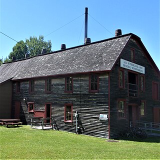
The Sutherland Steam Mill Museum is a restored steam woodworking mill from the 1890s located in Denmark, Nova Scotia. The mill operated until 1958. Today it is part of the Nova Scotia Museum system.
Maitland, East Hants, Nova Scotia is a village in East Hants, Nova Scotia. It is home to the historic Lawrence House Museum, which is part of the Nova Scotia Museum. The community was part of the Douglas Township until it was named Maitland after Governor General of Nova Scotia Peregrine Maitland (1828–34) when building the Shubenacadie Canal was first attempted (1826–1831). The Canal was supposed to start at Maitland, Nova Scotia and run through the province to Maitland Street, Dartmouth, the canal being "bookended" by two "Maitland" landmarks.
Upper Rawdon is a community in the Canadian province of Nova Scotia, located in the Municipal District of East Hants, which is in Hants County, Nova Scotia. This community was originally part of the Rawdon Township.

South Maitland is a community in the Canadian province of Nova Scotia, located in the Municipal District of East Hants, Hants County, Nova Scotia. The community was one of the stops on the Shubenacadie Canal system and the site of a number of 19th century shipyards including the yard that built the barque Calburga in 1890, the last large square rigger to sail under a Canadian flag. The village is best known for the historic bridge built over the Shubenacadie River, a large bridge built over challenging tidal waters by the Midland Railway, part of the Dominion Atlantic Railway in 1901. Demolished in the 1990s, a surviving abutment of the railway bridge was retrofitted in 2006 by the Fundy Tidal Interpretive Centre at South Maitland as an interpretive lookoff and walking trail showcasing the massive tides of the Shubenacadie River. A former railway caboose is also preserved beside the interpretive tail.
South Victoria is a small community in the Canadian province of Nova Scotia, in Cumberland County.
The Cobequid Pass is the name given to a 45 km (28 mi) tolled section of Nova Scotia Highway 104 between Thomson Station, Cumberland County and Masstown, Colchester County in the Canadian province of Nova Scotia. The section is a public–private partnership; the highway is owned by the Highway 104 Western Alignment Corporation, a Crown corporation of the Government of Nova Scotia, with a toll plaza operated under contract by Atlantic Highway Management Corporation Limited, a subsidiary of Aecon Concessions. The toll plaza is located near the halfway point in Londonderry. It opened in 1997.
Lower South River is a community in the Canadian province of Nova Scotia, located in Antigonish County.
Folly Mountain is a mountain and a community in the Canadian province of Nova Scotia, located in Colchester County on Trunk 4 in the Cobequid Hills.
South Branch is a community in the Canadian province of Nova Scotia, located in Colchester County. The Community is named for the South Branch of the Stewiacke River.
There are various Black Lakes in Nova Scotia, Canada. They vary widely in size, depth and usability. Many counties, such as Cumberland, Halifax, Inverness, and Pictou Counties have more than one Black Lake so named, while other counties mentioned in this article have only one named Black Lake.
The River Philip is a river contained entirely within Cumberland County, Nova Scotia, Canada.

The Stewiacke River is a river in the Canadian province of Nova Scotia that starts at Round Lake in Pictou County and flows into the Shubenacadie River in Colchester County running through the Stewiacke Valley.
The Chedabucto Fault is a fault that divides Mainland Nova Scotia from the Minas Basin in the west to Chedabucto Bay in the east into the Avalon zone in the north and the Meguma Zone in the south. The Avalon and Meguma Zones are different because they belonged to different land masses that were widely separated from one another. The Avalon Zone was a part of Laurasia, while the Meguma Zone was a part of Gondwana. It marks the southern margin of the Cobequid Mountains. The Cobequid-Chedabucto Fault Zone is the most prominent geological feature of Nova Scotia.

A township in Nova Scotia, Canada, was an early form of land division and local administration during British colonial settlement in the 18th century. They were created as a means of populating the colony with people loyal to British rule. They were typically rural or wilderness areas of around 100,000 acres (400 km2) that would eventually include several villages or towns. Some townships, but not all, returned a member to the General Assembly of Nova Scotia; others were represented by the members from the county. Townships became obsolete by 1879 by which time towns and counties had become incorporated.
