Related Research Articles
Sir Sandford Fleming Park is a 95-acre (38 ha) Canadian urban park located in the community of Jollimore in Halifax Regional Municipality. It is also known as Dingle Park or simply The Dingle, named after the town of Dingle in southwestern Ireland. The park was donated to the people of Halifax by Sir Sandford Fleming. The centrepiece of the park is an impressive tower that commemorates Nova Scotia's achievement of representative government in 1758. Constructed between 1908 and 1912, the Memorial Tower was erected during the same period of building other commemorative towers in the British Commonwealth, notably Cabot Tower in Bristol, England (1898) and Cabot Tower in St. John's (1900).
Spryfield is community within the urban area of Halifax, Nova Scotia, Canada.

The North End of Halifax is a neighbourhood of Halifax, Nova Scotia occupying the northern part of Halifax Peninsula immediately north of Downtown Halifax.
The Halifax Peninsula is a peninsula within the urban area of the Municipality of Halifax, Nova Scotia.

The South End is a neighbourhood within Halifax's urban area, in the Municipality of Halifax, Nova Scotia, Canada.
Highway 102 is a north–south highway in the Canadian province of Nova Scotia that runs from Halifax to Onslow, immediately north of the town of Truro. It is the busiest highway in Atlantic Canada.
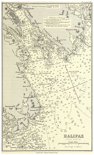
Halifax Harbour is a large natural harbour on the Atlantic coast of Nova Scotia, Canada, located in the Halifax Regional Municipality. Halifax largely owes its existence to the harbour, being one of the largest and deepest ice-free natural harbours in the world. Before Confederation it was one of the most important commercial ports on the Atlantic seaboard. In 1917, it was the site of the world's largest man-made accidental explosion, when the SS Mont-Blanc blew up in the Halifax Explosion of December 6.
Clayton Park is a community within Halifax, Nova Scotia, Canada.
Rockingham is a community located within the urban area of the Municipality of Halifax, in Nova Scotia, Canada.

Long Lake Provincial Park is located in Halifax, Nova Scotia, Canada. It was initiated in 1981 by then Premier John Buchanan after Halifax's water supply had been shifted from the Spruce Hill/Long Lake/Chain Lakes watershed to the Pockwock Lake watershed near Hammonds Plains. The 2,095-hectare (5,180-acre) park, formally established in 1984, constitutes the bulk of these former watershed lands. Other portions were deeded to the municipality of Halifax, and the area around the Chain Lakes is still administered by the Halifax Regional Water Commission, since the Chain Lakes remain the city's emergency water supply.
Burnside Drive is a four-lane divided roadway, with a speed limit of 80 km/h, that serves the Burnside Business Park in the Halifax Regional Municipality (HRM) community of Dartmouth, Nova Scotia. The road parallels Highway 118, running north from exit 3 of Highway 111 to Akerley Boulevard, a western extension of Highway 107. Although some maps produced by the province show Burnside Drive, as well as a portion of Akerley Boulevard, as part of Highway 107, these roads are actually maintained by the HRM, and Highway 107 becomes Akerley Boulevard about halfway between Highway 118 and Burnside Drive.

Robie Street is a north-south artery that runs for 7 km in the Halifax Peninsula area of the Halifax Regional Municipality from Memorial Drive in the North End to Gorsebrook Avenue in the South End.
West Pennant is a rural community located at the head of Pennant Harbour near Sambro on the Chebucto Peninsula in the Halifax Regional Municipality Nova Scotia on Route 349 West Pennant is an old fishing community that sits on Fawson and Long Coves that open into Pennant Harbour. There are nearby islands: Martin Island, Powers Island, and Pennant Island. Powers Island is privately owned. Once Mi'k Maq hunting and fishing grounds, West Pennant has been occupied by three dominant colonial families since the mid 1700s: the Marriotts, Grays, and Toughs. Just 25 minutes from Halifax, West Pennant is evolving into a suburb of Halifax with many local residents moving in from other parts of Canada and overseas. Until the 1970s most families earned their living fishing, now most families have one or more members who work in Halifax-Dartmouth. West Pennant is also home to cottagers. The local corner store is Mishoo's Right Stop. West Pennant is only a few kilometres from Crystal Crescent Beach Provincial park, a unique beach flanked with granite outcrops and white sand beaches. West Pennant also borders Terrance Bay Wilderness area. Local wildlife include porcupines, deer, coyotes, bobcat, black bear, pheasant, partridge, bald eagles, golden eagles, herring gulls, osprey, beaver, moles, shrew, monarch butterfly (seasonal), raccoon, mink, muskrat, otter, harbour seals, blue jays, american goldfinch, american robin, hummingbirds (seasonal), bobcat, and possibly cougar, and right whale. Fishing is a common occupation and hobby. The dominant species caught in Pennant Harbour are Atlantic Cod, Mackerel, Boston Blue Fish, and further out, Halibut, Swordfish, and Haddock. Squid can be caught off of the government wharf in Sambro during summer nights. There is also a commercial fishery for lobster. Once the poor man's food, lobster is now a local delicacy.
Pennant Point is a rural community located at the head of Pennant Harbour near Sambro on the Chebucto Peninsula in the Halifax Regional Municipality Nova Scotia on Route 349.

The West End is a neighbourhood of Halifax Regional Municipality in the Canadian province of Nova Scotia, located on the western half of the Halifax Peninsula. The West End is predominantly middle class with many blocks of tree-lined older residential streets. However, it is also home to many students and small low rent units. Rising real estate prices have also led to some levels of gentrification.

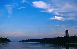
Sambro Island Lighthouse is a landfall lighthouse located at the entrance to Halifax Harbour, Nova Scotia, on an island near the community of Sambro in the Halifax Regional Municipality. It is the oldest surviving lighthouse in North America and its construction is a National Historic Event.
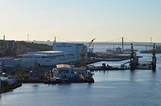
The Halifax Shipyard Limited is a Canadian shipbuilding company located in Halifax, Nova Scotia.

Bridgeview is a Residential subdivision, developed by B.D Stevens in the 1960s. Located in the community of Rockingham on Mainland Halifax, just off the Bedford Highway, it is considered to be part of the Halifax Regional Municipality, Nova Scotia, and is found on the shore of the Bedford Basin in Halifax Harbour.
Dunbrack Street is a 9.2 km (5.7 mi) arterial road in Mainland Halifax, Nova Scotia. It runs from Route 306 in Spryfield to Kearney Lake Road in Rockingham. Prior to 2019, Dunbrack Street ran from Kearney Lake Road in Rockingham to Main Avenue in Fairview. The remaining section was named Northwest Arm Drive. The former Northwest Arm section is assigned Trunk 32 by the provincial transportation department as an unsigned highway.

The Cogswell Interchange is a multi-level highway interchange in downtown Halifax, Nova Scotia, Canada. It was built as the first stage of a greater scheme for an elevated freeway, called Harbour Drive, which would have run south through downtown and necessitated demolition of much of the downtown building stock. The plan was halted in the face of significant public opposition, but the Cogswell Interchange remains a visible reminder, occupying a large amount of prime land and posing a barrier to pedestrian movement.
References
- Destination Nova Scotia (link dead - May 6, 2010)
44°35′39.7″N63°38′18.6″W / 44.594361°N 63.638500°W
| | This Halifax County, Nova Scotia location article is a stub. You can help Wikipedia by expanding it. |