Halifax Harbour is a large natural harbour on the Atlantic coast of Nova Scotia, Canada, located in the Halifax Regional Municipality.

Deadman's Island is a small peninsula containing a cemetery and park located in the Northwest Arm of Halifax Harbour in Nova Scotia, Canada. The area was first used as a training grounds for the British military, and later became a burial ground for dead prisoners of war from nearby Melville Island. In the early 1900s the site became an amusement park before being annexed to the city of Halifax in the 1960s. Though development projects were considered for the site, these plans met with popular protest, and instead Deadman's Island became a heritage park, Deadman's Island Park.

Purcell's Cove is a community within the Halifax Regional Municipality, Nova Scotia, Canada, on the west side of Halifax Harbour from the Northwest Arm to Ferguson's Cove along Route 253.
Birch Cove is a subdivision and a cove in the community of Bedford area of the Halifax Regional Municipality, Nova Scotia, Canada, on the shore of Bedford Basin and along the Bedford Highway. The name is after the birch trees that hung over the cove by William Donaldson, who named his estate Birch Cove.
Boulderwood is a Residential subdivision in Armdale on Mainland Halifax within the Halifax Regional Municipality Nova Scotia on the shore of the Northwest Arm in Halifax Harbour.
Halifax Northwest was a provincial electoral district in Nova Scotia, Canada, that was formed in 1956 and elected one member of the Nova Scotia House of Assembly. In 1966, the district was renamed Halifax County North West, and the following year, in 1967, the district was redistributed to form Halifax Cobequid.
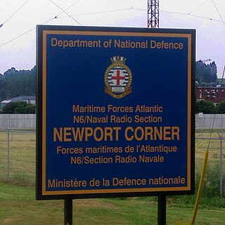
Naval Radio Section Newport Corner is a Canadian Forces naval radio station located in Brooklyn, Nova Scotia. Founded in 1942, it is still in operation today but remotely controlled from CFB Halifax.
Canadian Forces Station Mill Cove is a former Canadian Forces Station and currently a naval radio station located near Hubbards, Nova Scotia. Built in 1967, it is remotely operated by the Canadian Forces from CFB Halifax.
Portuguese Cove is a rural community in the Halifax Regional Municipality, Nova Scotia on Route 349 on the Chebucto Peninsula.
Hackett's Cove is a rural community of the Halifax Regional Municipality in the Canadian province of Nova Scotia on the Chebucto Peninsula.
Convoy Place is a residential neighbourhood in Halifax on the Halifax Peninsula within the Halifax Regional Municipality of Nova Scotia.
Fairmount, Nova Scotia is a residential neighbourhood in Halifax, Nova Scotia. It encompasses Mount Olivet Cemetery (Halifax) which contains the graves of some victims Titanic disaster and the Halifax Explosion and Sir Charles Tupper.
The Northwest Arm Drive is a 4-lane divided highway that runs entirely in Halifax in the Halifax Regional Municipality connecting Nova Scotia Highway 102 in Clayton Park to Nova Scotia Route 306 in Spryfield. The highway is a stub of the incomplete "Harbour Drive" project which would have connected Nova Scotia Highway 102 with the Halifax waterfront, via a bridge over the Northwest Arm and a 6-lane highway through the south end along Water Street and along Barrington past Cogswell. The project was cancelled in the 1970s in the wake of public opposition, but not before Northwest Arm Drive and the Cogswell Street Interchange were completed.
Sandy Cove is a community of the Halifax Regional Municipality in the Canadian province of Nova Scotia on the Chebucto Peninsula.
Bear Cove is a rural community of the Halifax Regional Municipality in the Canadian province of Nova Scotia on the Chebucto Peninsula.
The Dartmouth Yacht Club is a yacht club located in Wright's Cove in Halifax Harbour's Bedford Basin, next to Burnside Industrial Park in Dartmouth, Nova Scotia, Canada. The club has a history dating to 1962.
Wright's Cove is a cove on the Dartmouth side of Bedford Basin in Halifax Harbour Nova Scotia Canada within the Halifax Regional Municipality. Located in the cove is the Dartmouth Yacht Club, an Ultramar wharf, a Gypsum loading facility operated by National Gypsum Company and a Canadian Forces armament depot . The cove is sheltered from Bedford Basin by Navy Island and Sheppard's Island. It is the birthplace of George Henry Wright.
CIRP-FM is a non-profit radio station which broadcasts a Christian radio format from Spryfield, Nova Scotia, a community in the Halifax Regional Municipality. The station is owned by City Church of Halifax on Herring Cove Road. CIRP-FM plays Light Christian Contemporary music in the morning and Southern Gospel music later in the day.

Cambridge Military Library is a public library building in Royal Artillery Park (Halifax) in Halifax, Nova Scotia, Canada which was created in 1886. The building was created to house the garrison library collection, which had been moved from various locations in the city since its creation in 1817. It is the oldest library collection in Atlantic Canada. This building was the social and literary centre of military Halifax. In 1902, the officers of the garrison requested the library be named after the Prince George, Duke of Cambridge.
Tatamagouche Mountain is a community in the Canadian province of Nova Scotia, located in Colchester County.