This is a list of communities in Richmond County, Nova Scotia.
Communities are ordered by the highway upon which they are located. All routes start with the terminus located near the largest community.
St. George's Bay - informally referred to as Bay St. George due to its French translation Baie St-George - is a large bay in the province of Newfoundland and Labrador, Canada. It is located on the west coast of the island of Newfoundland and comprises a sub-basin of the Gulf of St. Lawrence.

The Great Northern Peninsula is the largest and longest peninsula of Newfoundland, Canada, approximately 270 km long and 90 km wide at its widest point and encompassing an area of 17,483 km2. It is defined as that part of Newfoundland from Bonne Bay northwards around Cape Norman and Cape Bauld and thence southwards to the head of White Bay, bounded by the Gulf of St. Lawrence on the west, the Strait of Belle Isle on the north and the Labrador Sea and White Bay on the east.
The Fleur-de-lis Trail is a scenic roadway located on Nova Scotia's Cape Breton Island. It is approximately 182 km (113 mi) long and runs along the southeastern part of the island through an Acadian region, with a 35 km (22 mi) spur route to and encircling Isle Madame, for a total distance of 217 km (135 mi).
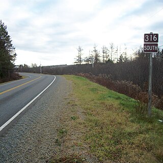
Route 316 is a collector road in the Canadian province of Nova Scotia. It is located in Antigonish County and Guysborough County, connecting Lower South River at Highway 104 with Half Island Cove at Trunk 16.
Grandique Ferry is a former community in Richmond County, Nova Scotia.
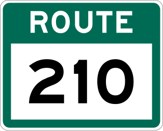
Route 210, also known as the Burin Peninsula Highway and Heritage Run, is a highway that extends through the Burin Peninsula from Goobies to Grand Bank, Newfoundland and Labrador. The maximum speed limit is 90 km/h except through communities and settlements where the speed limit is reduced to 50 km/h. Just after exiting Swift Current, until a few kilometres north of Marystown, much of the landscape is barren, with very few trees prevalent. After entering Marystown, motorists approach a junction where they could turn right to continue their journey on Route 210 until arriving at Grand Bank, or going straight onto Route 220 towards Burin and St. Lawrence. Marystown is the most populous community along the route.

Route 430 is a 413-kilometre-long (257 mi) paved highway that traverses the Great Northern Peninsula of Newfoundland in the Canadian province of Newfoundland and Labrador. The route begins at the intersection of Route 1 in Deer Lake and ends in St. Anthony. Officially known as the Great Northern Peninsula Highway, it has been designated as the Viking Trail since it is the main auto route to L'Anse aux Meadows, the only proven Viking era settlement in North America. It is the primary travel route in the Great Northern Peninsula and the only improved highway between Deer Lake and St. Anthony. It is the main access route to the Labrador Ferry terminal in St. Barbe.
Lower River Inhabitants is a small community in the Canadian province of Nova Scotia, located in Richmond County in Cape Breton Island. The River Inhabitants is born out of tributaries from the hills of Kingsville, Inverness County. These tributaries join to first form two branches of the River Inhabitants in Kingsville, which join together at Princeville, Inverness County. The main river then flows down through the communities of Princeville, Riverside, Cleveland, Grantville, Hureauville, and Lower River Inhabitants/Evanston to join Inhabitants Bay, known locally as Basin Inhabitants or Whiteside Basin. Port Hawkesbury is the market town of Lower River Inhabitants communities.
Louisdale is an unincorporated area within the Municipality of the County of Richmond, Nova Scotia, Canada. It is located on Cape Breton Island at the centre of an Acadian region. Founded mainly by families from nearby Petit-de-Grat, its early settlers were primarily of Acadian and, from the early 19th century, Scottish descent. It has two schools, park areas, and places to eat catering to tourists and residents.
Strait Area Transit is a provider of public transportation based in Inverness County and Richmond County, Nova Scotia, Canada. Established in 2008, it operates not as a government-sponsored agency, but rather as a non-profit cooperative charity. The organization offers daily fixed route, and Dial-A-Ride services in the South-Central Inverness County, Richmond County area.
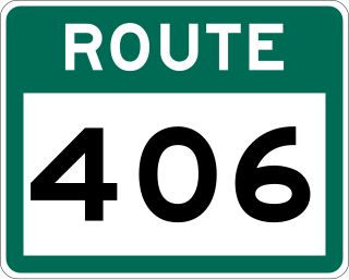
Route 406, also known as Codroy Road, is a highway on the western portion of Newfoundland in the Canadian province of Newfoundland and Labrador. It is a relatively short route, with its eastern terminus at Route 1 in the community of Doyles, and its western terminus at Cape Anguille. The route travels through the scenic Codroy Valley region.

Route 436, also known as L'Anse aux Meadows Road, is a 29.1-kilometre-long (18.1 mi) north-south highway on the Great Northern Peninsula of Newfoundland in the Canadian province of Newfoundland and Labrador. Its southern terminus is an intersection on Route 430, and its northern terminus is at L'Anse aux Meadows, a world-famous archaeological site.

Route 220 is the southern portion of the Heritage Run in the Canadian province of Newfoundland and Labrador, running along the southern and western coastlines of the Burin Peninsula of Newfoundland. It is a loop road, running due south from the town of Marystown and continues until the town of Grand Bank where it transitions into Route 210 - and vice versa. The speed limit along much of Route 220 is 80 km/h, except in communities where the speed limit is reduced to 50 km/h.

Route 11 is a 18.3-kilometre-long (11.4 mi) north-south highway located on the Avalon Peninsula of the island of Newfoundland in the Canadian province of Newfoundland and Labrador. It connects the town of Petty Harbour-Maddox Cove with Goulds and St. John's
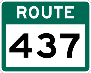
Route 437, also known as Cape Onion Road, is a 22.1-kilometre-long (13.7 mi) north-south highway on the northern edge of the Great Northern Peninsula of Newfoundland in the Canadian province of Newfoundland and Labrador. It connects the communities of Cape Onion-Ship Cove and Raleigh, along with Pistolet Bay Provincial Park, with Route 436 and St. Anthony.