Arichat, Nova Scotia

Last updated

Arichat
Unincorporated place
Canada Nova Scotia location map 2.svg
Red pog.svg
Arichat
Coordinates: 45°30′40.17″N61°0′46.5″W / 45.5111583°N 61.012917°W / 45.5111583; -61.012917
CountryFlag of Canada (Pantone).svg  Canada
ProvinceFlag of Nova Scotia.svg  Nova Scotia
Census division Richmond County
Established1785
Time zone UTC-4 (EST)
  Summer (DST) UTC-4 (AST)
Postal code span
B0E
Area code 902

Arichat is an unincorporated place in the Municipality of the County of Richmond, Nova Scotia, Canada. It is the main village on Isle Madame on the southeastern tip of Cape Breton Island.

Contents

Toponym

The name derives from a Mi'kmaq word meaning camping ground, or worn rocks. [1]

History

Arichat has a deep and protected natural harbour which made it an important fishing and shipbuilding centre in the 1800s. [2]

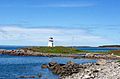
Jerseyman Island, which protects the harbour, was visited by Europeans fishermen as early as the 1500s. [3]

The village was sacked by John Paul Jones during the American Revolutionary War, after which two cannons were installed above the village.

The LeNoir Forge was an important boat building site and is now a museum. [4]

The first classes of St. Francis Xavier University began at Arichat in 1853, [5] later moving to Antigonish.

The Catholic Cathedral of Notre Dame de l'Assomption was constructed in 1835, having since been rebuilt. [6] It is the oldest surviving Roman Catholic Church in Nova Scotia. [7]

St. John's Anglican Church was built in 1828, destroyed by fire and rebuilt in 1895. [8] Considered to be the second oldest Anglican congregation in Cape Breton, the Church is noted for its amazing acoustic properties, a signature of its architect. [9]

Lighthouses were built in the 1850s, since replaced with replicas in 2017-2018.

In 1970, SS Arrow struck Cerberus Rock, releasing over 10,000 tons of oil, devastating the fishing industry. It is now a popular dive site. [10]

Related Research Articles

<span class="mw-page-title-main">Cape Breton Island</span> Island in Nova Scotia

Cape Breton Island is a rugged and irregularly shaped island on the Atlantic coast of North America and part of the province of Nova Scotia, Canada.

<span class="mw-page-title-main">Richmond County, Nova Scotia</span> County in Nova Scotia, Canada

Richmond County is an historical county and census division of Nova Scotia, Canada. Local government is provided by the Municipality of the County of Richmond.

<span class="mw-page-title-main">Joseph Frederick Wallet DesBarres</span> Swiss cartographer

Joseph Frederick Wallet Des Barres was a Canadian cartographer who served in the Seven Years' War, as the aide-de-camp to General James Wolfe.

<span class="mw-page-title-main">Baddeck</span> Village in Nova Scotia, Canada

Baddeck is a village in northeastern Nova Scotia, Canada. It is situated in the centre of Cape Breton, approximately 6 km east of where the Baddeck River empties into Bras d'Or Lake.

<span class="mw-page-title-main">Antigonish, Nova Scotia</span> Town in Nova Scotia, Canada

Antigonish is a town in Antigonish County, Nova Scotia, Canada. The town is home to St. Francis Xavier University and the oldest continuous Highland games outside Scotland. It is approximately 160 kilometres northeast of Halifax, the provincial capital.

Isle Madame is an island off southeastern Cape Breton Island in Nova Scotia. It is part of the Municipality of the County of Richmond.

<span class="mw-page-title-main">Diocese of Nova Scotia and Prince Edward Island</span> Diocese of the Anglican Church in Canada

The Diocese of Nova Scotia and Prince Edward Island is a diocese of the Ecclesiastical Province of Canada of the Anglican Church of Canada. It encompasses the provinces of Nova Scotia and Prince Edward Island and has two cathedrals: All Saints' in Halifax and St. Peter's in Charlottetown. Its de facto see city is Halifax, and its roughly 24 400 Anglicans distributed in 239 congregations are served by approximately 153 clergy and 330 lay readers according to the last available data. According to the 2001 census, 120,315 Nova Scotians identified themselves as Anglicans, while 6525 Prince Edward Islanders did the same.

The Fleur-de-lis Trail is a scenic roadway located on Nova Scotia's Cape Breton Island. It is approximately 182 km (113 mi) long and runs along the southeastern part of the island through an Acadian region, with a 35 km (22 mi) spur route to and encircling Isle Madame, for a total distance of 217 km (135 mi).

<span class="mw-page-title-main">Charles Robin</span>

Charles Robin was an entrepreneur from the Isle of Jersey who traded between the maritime region of Canada and the British Isles.

<span class="mw-page-title-main">Roman Catholic Diocese of Antigonish</span> Latin Catholic diocese in Canada

The Diocese of Antigonish is a Latin Church ecclesiastical jurisdiction or diocese of the Catholic Church in Nova Scotia, Canada. Its current diocesan ordinary is Wayne Joseph Kirkpatrick.

William Fraser was a Canadian Roman Catholic priest and the first Bishop of Halifax in Nova Scotia from 1842 to July 20, 1845. He was Bishop of Arichat from September 22, 1844. The difference in the dates is due to the splitting of the diocese into two dioceses effective September 22, 1844, and Fraser remaining Bishop of Halifax until such time that William Walsh took formal possession of the Diocese of Halifax.

Grandique Ferry is a former community in Richmond County, Nova Scotia.

<span class="mw-page-title-main">Higher education in Nova Scotia</span>

Higher education in Nova Scotia refers to education provided by higher education institutions. In Canada, education is the responsibility of the provinces and there is no Canadian federal ministry governing education. Nova Scotia has a population of less than one million people, but is home to ten public universities and the Nova Scotia Community College, which offers programs at 13 locations.

Boisdale is a community in the Canadian province of Nova Scotia, located in the Cape Breton Regional Municipality on Cape Breton Island. It was named for Lochboisdale, the main village of the island of South Uist in the Outer Hebrides of Scotland. Neil Campbell was granted land in the area in 1836. In 1821, Thomas Lockman, an Irishman who came to Cape Breton in 1799 and lived at Lloyds Cove, petitioned for land, and got a grant next to Neil Campbell's lot in 1842. Angus McIntyre got a grant in 1846, and in 1869, land at what was then called Boisdale was granted to Dugald O'Henley. Farming and lumbering were the basic industries. In 1840, a small log church was constructed by Father John Grant on where the present-day church resides. It was replaced by a new building in 1862, which burned down in September 1928. In 1846, Boisdale Parish was officially erected. A post office was established at Boisdale Chapel in 1854. On October 1, 1873 a new post office was established with Michael McIntyre as office keeper. In 1874, the total population of Boisdale, was that of 500. During this time, the area had 1 store, 3 sawmills, 1 grist mill, and a post office, of which mail was delivered bi-weekly. By 1908, it contained 1 hotel, 2 general stores, 1 saw mill, and 2 gristmills. The population at that time, was 300. In 1915, a newer 40,000 gallon open-wood tank was built replacing an older 40,000 gallon wood tank, for the water services within the area. Father Alexander F. MacGillivray, whom was the fifth pastor of Boisdale, had installed the bell within St. Andrew's Church in Boisdale, in 1882, and had built the Glebe house there in 1890. A new and larger bell, cast by the Meneely Bell Company of New York, was installed in St. Andrew's Church, by Father MacGillivray, on Nov. 14, 1897. In 1921, Father Gillis built St. Andrew's Parish Hall, James Johnston of Red Islands, Nova Scotia was the contractor. The formal opening of the hall was held on September 13, 1921. The original St. Andrew's Parish Church was destroyed by fire on Sunday, September 11, 1927. Construction of a new stone church commenced in June 1929, with help from workers from Quebec. The design style of the church was inspired by the Norman architecture as well as the St Mary the Virgin, Iffley church in England. Link, Weber, and Bowers, architects hailing from Pittsburgh, Pennsylvania, designed the architecture of the church. The approximate cost of the church was $55,000, but the exterior walls had to be repointed during the summer of 1930, which added an extra $7,500 to the total cost. The new church was blessed on Sunday, August 31, 1930, by Bishop James Morrison, assisted by the late Bishop Alexander MacDonald. In 1931, the total population of Boisdale was 449. There was also a train station located on Station Road, in Boisdale during this time. The former Glebe House for St. Andrew's Church was burnt down in 2011, due to a fire. Dugald Smith was the teacher in 1839, and a school-house had been constructed by that time. A new school-house was completed in 1917. Education within the area dates back to the early 1800s, with the Boisdale Consolidated School closing in 2003. The enrolment for the school, in the 1957–1958 academic year, were 82 students, and 3 teachers. By the 1987 Academic year, there were only 21 students, all within grades primary-second, and fourth. In 1943, within what is now known as Ironville, then known as Boisdale Barrachois until 1907, a youth summer camp was built. The two-week summer camp operated from 1943, until its closure in the 1980s. Efforts were made in 1997 to re-open the camp in the spring of 1998. The camp officially closed in 2010, due to the deterioration of some of the buildings. The property in which the youth camp was on, was sold in 2013. In August 1977, the community of Boisdale, as well as Father Webb, unveiled and held a ceremony for the opening of an indoor stone, ice-skating rink. Father Webb also built a Co-op store, in the 70s. A new hall above the store replaced the old Holyrood Hall, which burned down on December 18, 1975. By 1956, the population of Boisdale was 133. Over the years the population decreased, down to 138 by 1991, and estimated to be 105 by the 2001 Census.To the Hill of Boisdale,a book on the genealogical history of Boisdale was published in 1986, and later in a revised edition in 2001, by Father Allan MacMillan, then Priest of the Diocese of Antigonish. Highland Gold Maple, a family-owned and operated sugar maple producer, has been operating within the area for over fifteen years. In late April 2018, their operation burned to the ground due to a fire. By March 2019, Highland Gold Maple had rebuilt the Sugar Shack and are back in operation.

Petit-de-Grat is a small Acadian community in the Canadian province of Nova Scotia, located in Richmond County on Petit-de-Grat Island. Its name comes from the Basque word "dégrat" which means "fishing station" or "whaling station".

<span class="mw-page-title-main">East Bay, Nova Scotia</span> Unincorporated community in Nova Scotia, Canada

East Bay is a community in the Canadian province of Nova Scotia, located in the Cape Breton Regional Municipality on Cape Breton Island. It is situated on the south side of the East Bay of the Bras d'Or Lake, from which it gets its name. East Bay has one public beach and a large number of summer cottages with beach front property. Home of famous Fish & Chips, and East Bay Country Market, located on the Eskasoni turn off.

Louisdale is an unincorporated area within the Municipality of the County of Richmond, Nova Scotia, Canada. It is located on Cape Breton Island at the centre of an Acadian region. Founded mainly by families from nearby Petit-de-Grat, its early settlers were primarily of Acadian and, from the early 19th century, Scottish descent. It has two schools, park areas, and places to eat catering to tourists and residents.

<span class="mw-page-title-main">Strait Area Transit</span>

Strait Area Transit is a provider of public transportation based in Inverness County and Richmond County, Nova Scotia, Canada. Established in 2008, it operates not as a government-sponsored agency, but rather as a non-profit cooperative charity. The organization offers daily fixed route, and Dial-A-Ride services in the South-Central Inverness County, Richmond County area.

<span class="mw-page-title-main">Lennox Passage Provincial Park</span> Provincial park in Nova Scotia, Canada

Lennox Passage Provincial Park is a small picnic and beach park on the shores of Lennox Passage on the North Shore of Isle Madame on Cape Breton Island, Nova Scotia, with 2 kilometres (1.2 mi) of shoreline, an operating lighthouse and site of a former post office, ferry terminal and two limestone quarries. Visitors can picnic at tables scattered through a forest and open areas, enjoy the 2 kilometres (1.2 mi) of trails, or explore the working lighthouse. In summer the park offers swimming, kayaking, and biking opportunities. There are snowshoeing and cross-country skiing opportunities in the winter, however parking is available at the gate only in the off-season.

<span class="mw-page-title-main">Grandique Point Lighthouse</span> Lighthouse

Grandique Point Lighthouse is an aid to navigation for Lennox Passage, which is the channel of water between the southern shore of Cape Breton Island and Isle Madame, Nova Scotia, Canada. The lighthouse is located on the beach at Grandique Point in Lennox Passage Provincial Park and is accessible by a gravel road within the provincial park. The site is open to the public, the tower is closed.

References

  1. "Place-Names and Places of Nova Scotia". Nova Scotia Archives. 20 April 2020. Retrieved 30 July 2021.
  2. "Arichat". Fodor's. 1 April 2016. Retrieved 30 July 2021.
  3. "Jerseyman Island". www.jerseymanisland.ca. Retrieved 30 July 2021.
  4. "LeNoir Forge Museum". Tourism Nova Scotia. Retrieved 30 July 2021.
  5. Cameron, James D (1996). For the People: A History of St. Francis Xavier University. McGill-Queen's University PRess. pp.  16. ISBN   0-7735-1385-X.
  6. "Grow Isle Madame". www.growislemadame.com. Archived from the original on 26 October 2016. Retrieved 26 October 2016.
  7. "HistoricPlaces.ca - HistoricPlaces.ca". www.historicplaces.ca. Retrieved 26 October 2016.
  8. "Grow Isle Madame". www.growislemadame.com. Archived from the original on 26 October 2016. Retrieved 26 October 2016.
  9. Ayerd, Tom (18 June 2014). "Church closure blindsided members". Archived from the original on 6 October 2014. Retrieved 13 April 2017.
  10. Atlantic, Maritime Museum of the (30 June 2005). "On the Rocks: Shipwrecks of Nova Scotia - Maritime Museum of the Atlantic, Halifax, Nova Scotia". novascotia.ca. Retrieved 26 October 2016.

45°30′40.17″N61°0′46.5″W / 45.5111583°N 61.012917°W / 45.5111583; -61.012917