Strait of Canso

Last updated
Oceangoing vessel loading rock at Cape Porcupine in the Strait of Canso Cape breton island 3.jpg
Oceangoing vessel loading rock at Cape Porcupine in the Strait of Canso

The Strait of Canso (also Gut of Canso or Canso Strait, also called Straits of Canceau or Canseaux until the early 20th century) connects mainland Nova Scotia and Cape Breton Island, in eastern Canada. [1] [2] [3]

It is a channel approximately 27 kilometers long and averaging 3 kilometers wide (1 km at its narrowest). The strait connects Chedabucto Bay on the Atlantic Ocean to St. George's Bay on the Northumberland Strait, a subbasin of the Gulf of St. Lawrence.

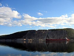
The strait is (200+ feet) deep, with two significant communities at Port Hawkesbury on the eastern side facing Mulgrave on the western side, both ports. The strait is crossed by the Canso Causeway for vehicular and rail traffic, opened in 1955. The Canso Canal allows ships to pass through the causeway, and this can accommodate any vessel capable of transiting the St. Lawrence Seaway.

An account of early settlement in the area is given in the letters of resident Henry Nicholas Paint (1830–1921), Member of Parliament for Richmond county and merchant, whose father Nicholas secured valuable land grants and settled in a stone-built house at Belle Vue in 1817. [4] Port Hawkesbury, at first known as Ship Harbour, emerged as a shipbuilding and boatbuilding port on the Strait in the 19th century with firms such as H.W. Embree and Sons producing distinctive fishing boats that came to be known as "Canso Boats" after the Strait.

Related Research Articles

<span class="mw-page-title-main">Cape Breton Island</span> Island in Nova Scotia, Canada

Cape Breton Island is a rugged and irregularly shaped island on the Atlantic coast of North America and part of the province of Nova Scotia, Canada.

<span class="mw-page-title-main">Bering Strait</span> Strait between Asia and North America

The Bering Strait is a strait between the Pacific and Arctic oceans, separating the Chukchi Peninsula of the Russian Far East from the Seward Peninsula of Alaska. The present Russia-United States maritime boundary is at 168° 58' 37" W longitude, slightly south of the Arctic Circle at about 65° 40' N latitude. The Strait is named after Vitus Bering, a Danish-born Russian explorer.

<span class="mw-page-title-main">Gulf of St. Lawrence</span> Outlet of the North American Great Lakes via the St. Lawrence River into the Atlantic Ocean

The Gulf of St. Lawrence fringes the shores of the provinces of Quebec, New Brunswick, Nova Scotia, Prince Edward Island, Newfoundland and Labrador, in Canada, plus the islands Saint-Pierre and Miquelon, possessions of France, in North America.

<span class="mw-page-title-main">Cabot Strait</span> Channel in Cape Breton Island, Nova Scotia & Newfoundland

Cabot Strait is in Atlantic Canada between Cape Ray, Newfoundland, and Cape North, Cape Breton Island. The strait, approximately 110 kilometres wide, is the widest of the three outlets for the Gulf of Saint Lawrence into the Atlantic Ocean, the others being the Strait of Belle Isle and Strait of Canso. It is named for the Italian explorer Giovanni Caboto.

<span class="mw-page-title-main">Canso Causeway</span> Causeway connecting Cape Breton Island with mainland Nova Scotia

The Canso Causeway is a 1,385 m (4,544 ft) rock-fill causeway crossing the Strait of Canso, provides access by road to the Atlantic Ocean, to the Gulf of St. Lawrence or Cape Breton Island to the Nova Scotia peninsula.

<span class="mw-page-title-main">Causeway</span> Route raised up on an embankment

A causeway is a track, road or railway on the upper point of an embankment across "a low, or wet place, or piece of water". It can be constructed of earth, masonry, wood, or concrete. One of the earliest known wooden causeways is the Sweet Track in the Somerset Levels, England, which dates from the Neolithic age. Timber causeways may also be described as both boardwalks and bridges.

<span class="mw-page-title-main">Cape Breton and Central Nova Scotia Railway</span> Canadian railway line

The Cape Breton and Central Nova Scotia Railway is a short line railway that operates in the Canadian province of Nova Scotia. CBNS operates of main line and associated spurs between Truro in the central part of the province to Point Tupper on Cape Breton Island.

<span class="mw-page-title-main">Canso Canal</span> Canal in Nova Scotia, Canada

The Canso Canal is a short canal located in Nova Scotia, Canada.

Highway 104 in Nova Scotia, Canada, runs from Fort Lawrence at the New Brunswick border near Amherst to River Tillard near St. Peter's. Except for the portion on Cape Breton Island between Port Hawkesbury and St. Peter's, it forms the main route of the Trans-Canada Highway across the province.

<span class="mw-page-title-main">Mulgrave, Nova Scotia</span> Town in Nova Scotia, Canada

Mulgrave is a town on the Strait of Canso in Guysborough County, Nova Scotia, Canada. Located along the Marine Drive, Route 344 traverses the community. The town's current name was adopted in 1859 to honour the colonial Lieutenant Governor, the Earl of Mulgrave. Lying opposite to the town of Port Hawkesbury, the community is located along the western shore of the Canso Strait. It was established as McNair's Cove in the early 19th century, and the name Port Mulgrave was adopted in 1859, later shortening to its current form. The early industry of the community relied on ferry service between the Nova Scotia mainland and Cape Breton Island. Ferry service began in the 1810s and rail service reached the area in the 1880s. The ferry services lasted until the opening of the Canso Causeway in 1955, dealing a major blow to the local economy. As of 2016, Mulgrave has a population of 722 and a population density of 40.5/km2 (104.9/sq mi), within an area of 17.83 km2 (6.88 sq mi).

<span class="mw-page-title-main">Inverness, Nova Scotia</span> Place in Nova Scotia, Canada

Inverness is a Canadian rural community in Inverness County, Nova Scotia. It is about an hour's drive north from the Canso Causeway and about an hour south from Cape Breton Highlands National Park. In 2021, its population was 1,228, down 1.6% from 2016.

The Marine Drive is a designated scenic route along Nova Scotia's Eastern Shore. It closely follows the coast of the Atlantic Ocean and the Strait of Canso from the Canso Causeway to the junction of Route 322 and Highway 111 in Dartmouth.

Point Tupper is a rural community in Richmond County, Nova Scotia, on the Strait of Canso, in western Cape Breton Island.

Port Hastings is an unincorporated settlement on Cape Breton Island, within the Municipality of the County of Inverness, Canada. The population in 2021 was 90.

<span class="mw-page-title-main">Henry Nicholas Paint</span> Canadian politician

Henry Nicholas Paint was a Canadian politician, shipowner and merchant.

<span class="mw-page-title-main">Aulds Cove</span> Human settlement in Nova Scotia, Canada

Aulds Cove is a community in the Canadian province of Nova Scotia, located in both Antigonish County and Guysborough County.

Chedabucto Bay is a large bay on the eastern coast of mainland Nova Scotia between the Atlantic Ocean and the Strait of Canso next to Guysborough County. At the entrance to Chedabucto Bay is the community of Canso at the head is the community of Guysborough and on the other end is the town of Mulgrave.

St. Georges Bay is a bay with shore on the Nova Scotia peninsula and Cape Breton Island, Canada, thus comprising a sub-basin of the Gulf of St. Lawrence.

<span class="mw-page-title-main">Lennox Passage (waterway)</span> Strait in Cape Breton Island, Nova Scotia

Lennox Passage is a navigable waterway between Cape Breton Island and Isle Madame in Nova Scotia, Canada. Small craft use the relatively protected Passage traveling to and from St. Peters Canal at the village of St. Peter's and the Strait of Canso to avoid sailing around the east coast of Cape Breton in the open Atlantic Ocean.

References

  1. 1 2 Gary L. Bugden; Brent A. Law; Edward P.W. Horne; Shawn E. Roach (2020). "Flow through the Canso Causeway" (PDF). Fischeries and Oceans Canada (in English and French). Canadian Technical Report of Fisheries and Aquatic Sciences. pp. 21 of 55. Retrieved 16 August 2024. Although blocked in the 1950s by the Canso Causeway, Canso Strait could potentially be a transport pathway for the spread of Malpeque Disease
  2. Strait of Canso Environment Committee (1975). "Water Resources" (PDF). p. 33. The Strait is relatively narrow, varying in width from 800 m to 2,000 m (2,600 to 6,600 ft.), although it is most commonly 1,600 m (1 mile) wide throughout the 27 km (17 mi.) length.
  3. "Canso Causeway - Road to the Isles". Canada's Digital collections. Retrieved 16 August 2024. The mile long eighty foot wide man-made causeway is known as the deepest in the world
  4. Mander, Nicholas (2005). Varnished Leaves: a biography of the Mander family of Wolverhampton. Owlpen: Owlpen Press. ISBN   0-9546056-0-8.

45°35′50″N61°22′38″W / 45.59722°N 61.37722°W / 45.59722; -61.37722